NYC Area Forecast: More rain likely tonight into Friday morning

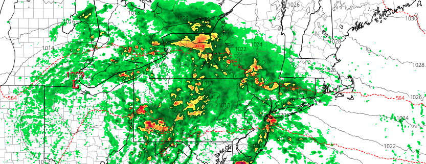
The Brief: Heavy rainfall is likely tonight into Friday. The NWS has issued a Flood Watch for a large majority of the Mid-Atlantic into New England. Localized flooding is a distinct possibility. The weather clears up for Friday and the weekend.

A forecast that once looked pleasant during the latter half of the week has turned unsettled, and you can thank the upper level jet stream (among other things) for that. Instead of cool, crisp air and sun, the end of the week will feature a period of heavy rainfall from late Thursday night into Friday as another low pressure system develops offshore and sends moisture surging up the coast.

Previously, forecast models had suggested that the rainfall would remain well offshore and that any impacts would be periodic and/or non-impactful. As recently as Tuesday, however, hints began to emerge that the forecast was changing. Forecast guidance was tweaking the orientation of the upper level jet stream, and the trends were a tip-off to the fact that the forecast late this week was about to take an ugly turn.

Read more

NYC Area Weekly Planner: Heavy Rain & Flooding Concerns to Start the Week

Good morning and Happy Monday! It’s a rough one out there this morning. Showers continue throughout the Northeast and Mid Atlantic, with temperatures in the 50’s and a very damp airmass in place. This weather is generally expected to persist today, but it will be particularly cool this morning. Bring a jacket and an umbrella along with you.

Read more

NYC Area Weekly Planner: Heat & Humidity Returns This Week

Happy Labor Day! We hope you have been enjoying the last holiday weekend of the summer. We saw a break from the heat and oppressive humidity over the last few days, but heat will return again early this week as another strong ridge builds over much of the Eastern US. Although the heat and humidity won’t be quite as oppressive, it will still be uncomfortable. For more details, read on!

Read more

PM Update: Heat continues, to be followed by more heat

Temperatures soared into the middle and upper 90’s today throughout the New York City area and, in fact, a large majority of the Northeast states. The heat was good for some records during the day (daily record at Islip, NY) and at night (many record warm overnight low temperatures were set). The temperature wasn’t even the real issue with the uncomfortable air – it was the dew point, which hovered in the low to middle 70’s.

Not much improvement is expected through the evening. Temperatures will remain very warm and dew points will remain very high, leading to another uncomfortably warm evening. Through tonight, a blend of weather models suggests the temperature will only fall into the upper 70’s or lower 80’s in and around the New York City metro area, which suggests record warm overnight low temperature records will be broken for the day again.

Read more