-2")
Significant Snowstorm Likely on Wednesday for Portions of the Northeast!
Good evening!
After a very significant Nor’Easter that impacted the Northeast this past weekend, it looks like we’ll have a shot at yet another system! However, we may have to deal with much more snow over the PHL-NYC corridor this time around.
Gradually making our way to the main system, today has been a rather calm, but cold day across the entire east coast as the area remains in a northerly flow coming in from Atlantic Canada. This is partly due in part to the large area of low pressure that impacted the east this past weekend with heavy rains, hurricane-force winds, and over 40″ of snow in some locations. After the moved off the coast, it was blocked from moving North and into the North Atlantic due to record-high blocking near Greenland. Regardless, this massive system has still had a large impact on our weather for the past three to four days now, but that will soon come to an end. Mid level ridging will increase just enough for a strong area of high pressure to attempt to build in over the Northeast this evening, allowing for calm and cold conditions to persist throughout the evening hours. Very dry mid to upper levels of the atmosphere in-between disturbances will ensure that clouds are kept at a minimum, and with clear skies and relatively light winds, we should see rather favorable conditions for radiational cooling to take place. This should allow lows this evening to drop into the middle to upper 20’s, with some locations off to the north and west seeing readings drop down into the lower 20’s.
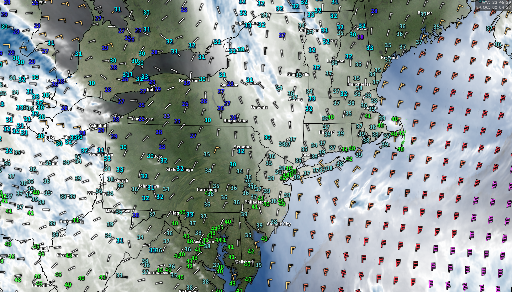
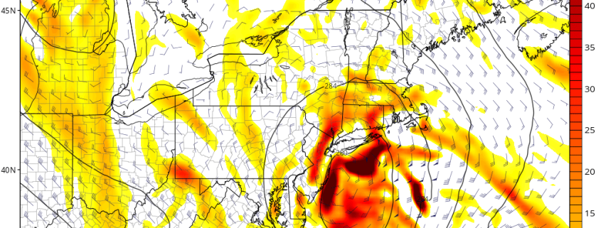
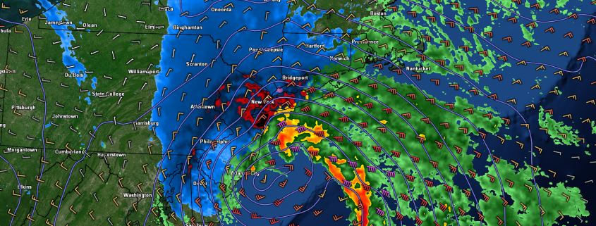
This evenings latest surface observations, surface winds, regional radar mosaic, and water vapor imagery
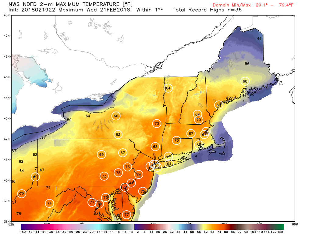
Significant Snowstorm Likely for Portions of the Northeast Wednesday
Tuesday morning will likely start off quite clear and cold as residual high pressure attempts to creep in ahead of our next system. Dry mid to upper levels of the atmosphere are expected to continue throughout most of the day, so expect sunny to partly cloudy skies for the vast majority of the day tomorrow. Winds will gradually become light and variable throughout the late afternoon hours as we await the arrival of the next system. With a cool mid level airmass in place, moderately sunny skies, and light winds, expect highs to only rise into the lower to middle 40’s tomorrow afternoon-with some locations further to the north and west likely staying in the upper 30’s.
Further west, we will be watching a large, and closed off piece of mid level energy that will be over Plains by tomorrow afternoon. This system has been producing heavy snow in the northern Plains, and some scattered strong thunderstorms in the south, but this will begin to change tomorrow afternoon as the surface low pressure begins to occlude and decay. As the surface low heads west and decays, a vigorous piece of energy over southern Canada will be forced south and into the Great Lakes region by tomorrow afternoon. This interaction will cause the nature of the trough in the eastern third of the country to become more negatively tilted, which is very important for the development of a secondary surface cyclone along the east coast. By tomorrow evening, we should see widespread showers extend from NY state and down into the Gulf of Mexico associated with the stalled out, and decaying front. As the night goes on, we should see a weak area of low pressure likely develop over, or just off the Mid Atlantic coast, which will be our main focus on Wednesday.
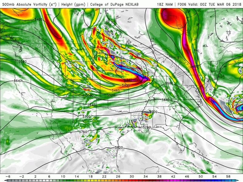
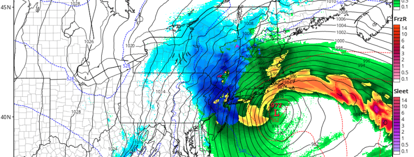
This evenings NAM model showing the mid level evolution leading up to our potentially significant snowstorm on Wednesday
Our mid level systems should be completely phased together by 8am Wednesday morning as the trough over the east goes fully negative. This will allow the weak area of low pressure near the Mid Atlantic to begin a period of rapid intensification thanks to an expanding upper level jet streak and an impressive amount of positive vorticity advection moving just off the Delmarva peninsula to promote heavy precip development. This systems precipitation shield should begin to rapidly expand once it begins to mature, with locations in Maryland, Southeast PA, Delaware, and southern New Jersey all receiving the first moderate to heavy bands of snow around 8-11am. These bands will gradually pivot and continue moving north/northeast as the day goes on, with some of the most intense banding likely holding off until the afternoon hours of Wednesday.
As the mid levels system matures, there are strong indications it should begin to close off at around 500mb. The quicker that this process occurs, the more the surface low will be able to tuck into the coast with intense banding spreading deeper into NJ/PA. As of this afternoon, the models keep the 500mb low from closing off until the mid-afternoon hours on Wednesday as the system is just off the NJ coast. As soon as this feature is able to close-off, we should see very strong vertical motion begin to develop over portions of NJ/NY, which is a strong signal for very heavy snow bands capable of producing snowfall rates in excess of 1-3″ per hours with pockets of thundersnow possible. While the intensity of the snow will be quite heavy, it is worth noting that this system is quite small in nature and moving quickly. This presents some problems for this forecast, as any subsequent deviations with the surface low can mean the axis of heaviest snowfall totals can change quite quickly/significantly. Additionally, this system could potentially bring in some warmer air on the backside of the low pressure, meaning places like coastal Long Island and Connecticut could see a changeover, or complete flip to rain during the afternoon hours on Wednesday. This would require a large reduction in overall snowfall totals, but for this forecast we have decided to leave it as is due to uncertainty.
Overall, we expect the heaviest snowfall to occur from SW to NE over SE PA, Central/Northern NJ, Southern NY, and possibly into portions of Connecticut. While this system will be moving quite quickly, the heaviest snows look to happen during the afternoon/early evening hours, with the evening commute possibly being heavily impacted. Snowfall rates may be too intense in some locations for road crews to keep up with, so please begin to come up with alternate plans if you will be traveling during the day on Wednesday. Otherwise, snow will begin to taper off during the early evening hours from south to north, with conditions clearing out by the overnight hours of Thursday. Accumulations should generally top off in the 9-12″ range, however there are some indications that locally higher amounts of up to 12-18″ could be possibly in the most intense banding. We will have another update tomorrow morning to address any changes that occurred overnight.
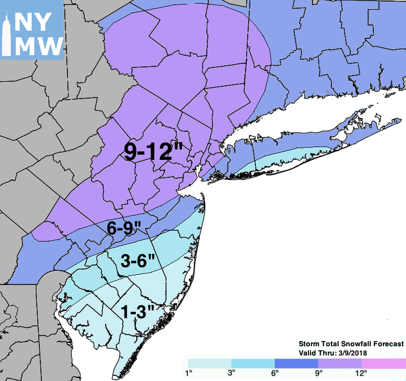
This evenings forecast storm total snowfall for Wednesday storm
Have a great evening!
Steven Copertino