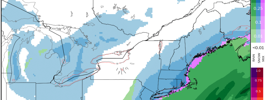
First Accumulating Snow of the Season Becoming Likely for the East Coast

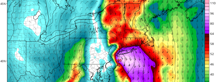
Good afternoon! In the world of weather, there has been a lot of model mayhem regarding a big shift in the data further northwest with a coastal storm, which is leading to the idea of accumulating snow across much of the Eastern US on Saturday. We believe that these ideas have a lot of merit, and in this article we are going to explain why, as well as overview some of our expectations.

In the macro sense, it’s not a complicated setup. We have a large ridge in the West, and a corresponding deep trough in the East, we have disturbances sliding down the ridge and entering the trough, and we also have a relatively stalled frontal boundary off the coast, providing a strong temperature gradient for a storm to ride, while also providing enough ridging in the Atlantic to keep the storm from sliding out to sea.

Read more

Significant storm system to impact Northeast states

A well discussed storm system is in the process of developing this Saturday evening and overnight, as a large and anomalous trough digs into the Mississippi River Valley. Meanwhile, Tropical Storm Phillippe continues to move swiftly through the Caribbean, shifting northeastward and eventually on track to interact with the aforementioned trough. While the two disturbances will not completely “phase”, they will interact – and the result will be the development of a powerful storm system by late Sunday.

Read more

La Nina is in the Atmosphere, but Changes are Possible

After some big warmth, we finally saw some Autumn chill arrive over the past couple of days, which signifies the change of seasons. We are now approaching crunch time when it comes to compiling a winter forecast. In our Winter Forecast Webinar, one of the main topics discussed was the evolution of the La Nina and the effects it is already having on the atmospheric pattern. With La Nina conditions already having been established with regards to feedback in the atmospheric circulation, and the fact that ENSO events tend to peak in November, it would seem to be a given that La Nina would be at least somewhat or even perhaps a major driver this coming winter. And to some extent, we believe that is true. However, there is conflicting evidence regarding the future of the La Nina, and part of this will be evidenced by a pattern change to a +PNA and a trough in the East later this month. These factors will be discussed in detail in this article.

Read more

Hurricane Maria’s Track May Depend on Jose

In what seems to be about day seven hundred in an endless cycle of Tropical news, we have plenty more to talk about. Hurricane Maria underwent rapid intensification last night, strengthening from a Category 1 to a Category 3 storm. It developed a very tight core with a rapid increase of lightning around the center — a classic foreboding of rapid intensification. This intensification has continued throughout the day, as it has now become a Category 4 hurricane with 130mph winds. This was evident because a classic pinhole eye opened up, reminiscent of some of the strongest hurricanes, such as Hurricane Gilbert. It is looking like Puerto Rico will take a direct hit from Maria, as perhaps a Category 4 or even 5 hurricane. Afterward, there is a lot of spread in potential outcomes, though the general pattern at large does signal a landfall somewhere along the East Coast. But a big variable will be how the remnants of Jose behave, something that will be very hard to forecast.

Read more