Meteorological winter is just one day away, and while snow lovers are beginning to get excited, much of the meteorological community is aware that the coming weeks are not likely to offer many wintry precipitation prospects. Our long range outlook will discuss the meteorological pattern for the upcoming 30 to 45 days. With an in depth look into meteorological patterns and the developing global circulations, we’ll explain the processes occuring that will drive our weather pattern through the month of December.
https://www.nymetroweather.com/wp-content/uploads/2015/11/longrange.png294868Miguel Pierrehttps://www.nymetroweather.com/wp-content/uploads/2024/02/Empire-2000-x-300-px-2.pngMiguel Pierre2015-11-30 11:04:132015-12-07 21:53:59Long Range Outlook: Active Pattern in December. But Will it Snow?
As we are currently in the midst of a January thaw, many people are looking ahead to find out when this thaw will end and when snow chances will begin. Some rumors had been spreading about a snowfall event on Wednesday/Thursday, and again around Saturday, but both of these threats appear unlikely to produce much in the way of snow. It is not until next week and beyond when we expect the pattern to become more favorable for snow.
Taking look at the threat, or lack-there-of, for Wednesday into Thursday, the main problems stem from a progressive pattern and one that is still in flux.
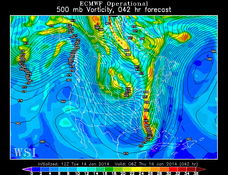
Today’s 12z European model shows an unfavorable look for a snowstorm on Wednesday night with a very progressive pattern. Image credit goes to the WSI Model Lab.
The above image is the 500mb pattern and vorticity that is forecast by the European model for Wednesday night. There is a large area of vorticity in the southeast states, but notice how it is very elongated and not consolidated. Also notice how there is another disturbance right on its heels in the Northern Plains and Midwest. This leads to shortwave ridging in the Ohio and Tennessee Valley, which penetrates the trough and forces it to be very narrow and progressive. Also working against the potential for a bigger system is the lack Atlantic blocking to help the pattern to buckle. Instead, the entire country has a NW to SE axis to the heights, instead of a more meridional north to south flow. Thus, there is no room for the trough to grow and amplify. So this disturbance slides out to sea, and does not impact the area. There may not be any precipitation at all in the Wednesday night into Thursday time period.
The same general theme holds true for the threat on Saturday.
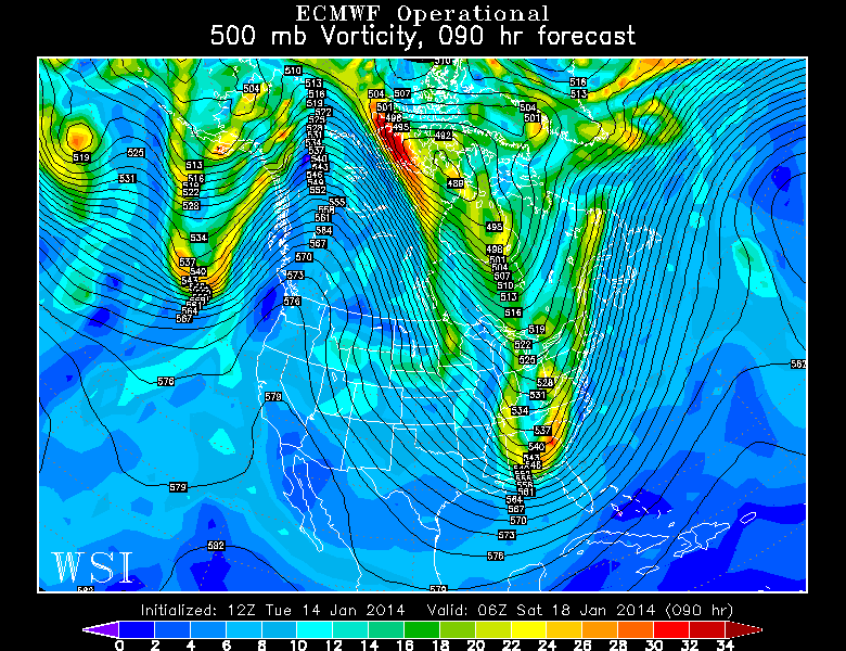
Today’s 12z European Model valid for Friday night shows a slightly improved pattern for snowfall, but still not one that ultimately supports a snow event. Image credit goes to the WSI Model Lab.
Moving forward to Friday night, we can notice a few important features. First of all, there is still a strong PNA ridge out west, which promotes a tough in the East, and could theoretically favor snowstorm chances. That being said, the Atlantic and Arctic blocking are still nowhere to be found, so the trough cannot buckle. It’s still a progressive pattern — one with a NW to SE height orientation throughout most of the country, which leaves no room for major trough amplification. We have a trough in the East, but once again, the vorticity is relatively disjointed and the trough is being pushed eastward. There is another disturbance right on its heels again in Minnesota, which forces weak shortwave ridging in Illinois, further preventing major amplification of any trough. By the time the trough is finally able to amplify and consolidate, it is already out to sea, with maybe a few passing snow showers. Eastern New England could potentially receive a couple of inches of snow, however.
https://www.nymetroweather.com/wp-content/uploads/2024/02/Empire-2000-x-300-px-2.png00Doug Simonianhttps://www.nymetroweather.com/wp-content/uploads/2024/02/Empire-2000-x-300-px-2.pngDoug Simonian2014-01-14 15:19:562014-01-14 21:06:01Chances for cold and snow are significantly increasing to close the month
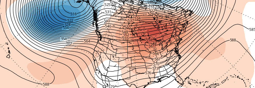
The pattern over recent weeks has proven to be an interesting one across the majority of the United States, as the record cold temperatures and plentiful snow has visited folks from the Mid-west, Great Lakes, and the Northeast. Our significant snowstorm last week was due in large part to the negative EPO / positive PNA regime in concert with a well-timed Greenland block, allowing short wave amplification to occur on the mid atlantic coast. Since that time, the Greenland block has dissipated, and the western ridge will collapse in a few days, not before a near record / record cold airmass arrives Monday night.
(Log in to view this post, or purchase it for $.99 !)
[s2Member-PayPal-Button sp=”1″ ids=”4153″ exp=”72″ desc=”View this Premium Long Range Post for only $.99!” ps=”paypal” lc=”” cc=”USD” dg=”0″ ns=”1″ custom=”www.nymetroweather.com” ra=”0.99″ image=”default” output=”button” /]
https://www.nymetroweather.com/wp-content/uploads/2024/02/Empire-2000-x-300-px-2.png00Tom Stavolahttps://www.nymetroweather.com/wp-content/uploads/2024/02/Empire-2000-x-300-px-2.pngTom Stavola2014-01-06 09:44:192014-01-06 09:47:07Mid January thaw a transient interruption in the pattern
Seasonal forecasting is one of the more tedious and intricate tasks for meteorologists. Not only is it difficult to predict by nature (no pun intended) — but forecast model accuracy skill is greatly reduced at that range. Often, meteorologists find themselves looking back towards past events, and analogs, for help with predicting the months ahead. In our case, interest was piqued when we noted what seemed to be higher than normal frequency of high latitude blocking this year. Hurricane Sandy, the nor’easter which immediately followed, and many events this winter featured patterns that were driven by blocking patterns over Canada, Greenland, and the higher latitudes towards the pole. The blocking pattern was not overly anomalous at least on a per-year basis, but it certainly seemed to be more frequent than the calendar year which preceded it.
As we look forward to May, forecast models are in agreement on the continuation of higher than normal height anomalies at 500mb over Central and Eastern Canada as well as farther north towards Greenland. The continuation of blocking in the higher latitudes, relative to our location, can offer some interesting insights into the summer temperature forecast as we move forward. Is there a common theme amongst the historically warm and historically cool summers in the NYC Area — and can we relate it to Springtime blocking patterns? The answer, may surprisingly to some, is yes. For the sake of example, take the summer of 2009 and the summer of 2010. Both of these years featured wildly different patterns, with 2009 remaining very cool throughout the summer while 2010 was warm. In 2009, there was very little blocking observed from March through May. 2010, on the other hand, featured periodic blocking in the high latitudes from February through May. Interested yet?
https://www.nymetroweather.com/wp-content/uploads/2013/04/gfs.png340720John Homenukhttps://www.nymetroweather.com/wp-content/uploads/2024/02/Empire-2000-x-300-px-2.pngJohn Homenuk2013-04-30 18:20:102013-05-01 23:27:15Does blocking in May hint at summer weather?
Hi friends! Our website uses cookies to provide an optimal browsing experience for you. New "Cookie Consent" laws mandate us to inform you of this. As long as you're cool with it, just hit OK. You'll only see this message once.
We may request cookies to be set on your device. We use cookies to let us know when you visit our websites, how you interact with us, to enrich your user experience, and to customize your relationship with our website.
Click on the different category headings to find out more. You can also change some of your preferences. Note that blocking some types of cookies may impact your experience on our websites and the services we are able to offer.
Essential Website Cookies
These cookies are strictly necessary to provide you with services available through our website and to use some of its features.
Because these cookies are strictly necessary to deliver the website, refusing them will have impact how our site functions. You always can block or delete cookies by changing your browser settings and force blocking all cookies on this website. But this will always prompt you to accept/refuse cookies when revisiting our site.
We fully respect if you want to refuse cookies but to avoid asking you again and again kindly allow us to store a cookie for that. You are free to opt out any time or opt in for other cookies to get a better experience. If you refuse cookies we will remove all set cookies in our domain.
We provide you with a list of stored cookies on your computer in our domain so you can check what we stored. Due to security reasons we are not able to show or modify cookies from other domains. You can check these in your browser security settings.
Other external services
We also use different external services like Google Webfonts, Google Maps, and external Video providers. Since these providers may collect personal data like your IP address we allow you to block them here. Please be aware that this might heavily reduce the functionality and appearance of our site. Changes will take effect once you reload the page.
-2")