November 2015 Outlook: Above Average Temperatures Likely

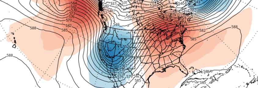
It’s that time of Autumn again, where weather enthusiasts start looking into the longer range forecasts for  telleconnections, pattern changes, and the first chance of snowfall; while everyone else who dreads winter will start shopping for new coats, boots and shovels. For now, it’s snow haters rejoice: It appears there will be very little wintry weather through most, if not all, of November.

Read more

PM Update: Cooler behind front, pleasant Halloween

Warm and moist air, which settled into the region on Wednesday Night, has been scoured out thanks to a cold frontal passage on Thursday afternoon. Sunny and warm conditions prevailed, thanks to lingering warm air near the surface, but temperatures in both the mid and low levels of the atmosphere will cool further overnight. Westerly winds took over for the southerly winds which had dominated beforehand, and will help to usher in the cooler airmass.

This trend will continue through Friday, with cooler air arriving throughout the Northeast United States. Highs will be several degrees colder than they were on Thursday. The air will feel crisp and, well, Autumn-like, with high temperatures topping out in the mid to upper 50’s with a westerly wind component.

Read more

Military blimp detaches from tether, drifts over PA

A military aerostat (being commonly referred to as a blimp) tethered at a military facility in Maryland broke loose on Wednesday. The aircraft then floated over Pennsylvania, and was last spotted near Bloomsburg.

The craft detached from its moorings at Aberdeen Proving Ground around noon on Wednesday afternoon, and was immediately being tracked by authorities. But the blimp then started to drift north/northeastward into Pennsylvania. Authorities warned that “anyone who sees the aerostat is advised to contact 911 immediately”.

Read more

Heavy rain, gusty winds likely on Wednesday

The interaction between tropical moisture — remnants of Hurricane Patricia — and a strong mid level atmospheric disturbance over the North Central US will aid in the development of steady rain on Wednesday. As forcing for precipitation increases during the morning hours, steady rains will develop from southwest to northeast throughout the area. Atmospheric moisture content will increase throughout the day, as a psuedo-warm front moves through New Jersey and New York.

Precipitable water values between 200 and 300 percent above average are a testament to the tropical moisture involved in Wednesday’s rains. During the late morning and afternoon, a low level jet stream is expected to strengthen, further aiding in the potential for heavy rains. While heavy rain isn’t expected to be constant, sporadic heavy rains could cause localized flooding, despite the moderate drought conditions in much of Northern New Jersey, New York and Connecticut.

Read more