Pleasant, seasonable weather will return this week

After a tumultuous series of events last week, including the potential for Hurricane Joaquin to significantly impact our area, this week is sure to feel extra-relaxing, especially for meteorologists. While the impacts of Joaquin remained mostly here-say, the intricacies of how close the storm really was to impacting the East Coast has left meteorologists breathing a sigh of relief.

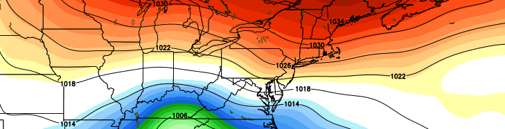
Luckily, the week looks likely to feature much more pleasant and quiet weather. Although we didn’t totally escape impacts from the anomalous pattern (See: Dangerous coastal and tidal flooding over the past several days), the upcoming one will be much quieter as a whole. High pressure will build in, with seasonable temperatures continuing. Precipitation is expected to stay out of the forecast until the latter half of the week.

Read more

Prolonged onshore winds, tidal flooding on area shores

While the main story of the past several days has obviously been Hurricane Joaquin, the synoptic pattern results in several weather hazards regardless of the storms path. As mentioned a few days ago, the path of Joaquin was a concern, but hazardous weather was likely to occur whether the storm tracked toward our area or not.

As a large high pressure system builds from our north toward Southeast Canada and New England, the lowering pressures to our south and east will aid in a continually tightening pressure gradient. At the surface, east/northeasterly winds will continue to surge toward the area coasts — specifically the New Jersey coast — resulting in increased wave heights. With rising tides and seas, coastal flooding is likely to occur through the weekend.

Read more

Joaquin strengthens, models shift dramatically seaward with track

As it moved through the very warm ocean waters near the Bahamas on Thursday, Hurricane Joaquin strengthened further, reaching Category 4 status on Thursday afternoon. Maximum sustained winds reached 130 miles per hour. The National Hurricane Center suggests additional strengthening is possible, with maximum sustained winds approaching 140 miles per hour.

Computer models have continued their immense struggles with the track and intensity of Joaquin. A storm which was modeled by only a select few to become a major hurricane just days ago, has strengthened far beyond additional expectations. One of the major reasons for this is a farther south track — into warmer waters — which also was not anticipated by modeling until 36-48 hours ago when the ECMWF was the first to suggest a southward jog.

Read more