Weekly Overview: Transitional weather, interior winter storm possible late week

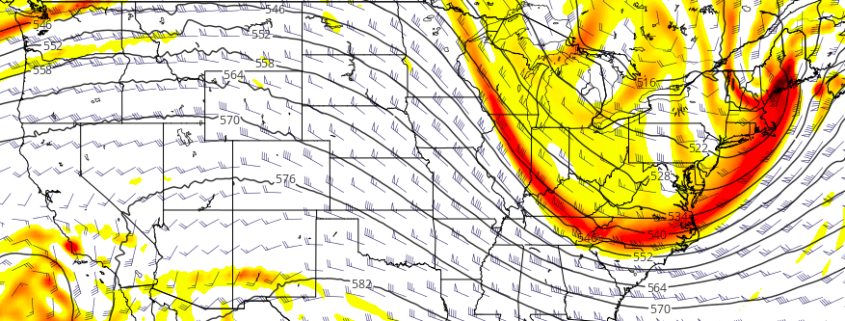
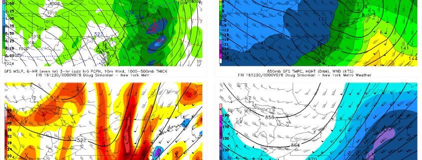
It was dreary today with lots of cloud cover and spotty light rain and drizzle in some areas. High pressure is now moving out into the Atlantic, while low pressure from the Midwest tracks into Southeast Canada.  This will allow for a warm front to lift further northward through the Northeast states this evening, with winds turning more southwest overnight. Cloud cover will remain in place most of the night with some light rain or drizzle still possible.

Temperatures will gradually rise through the 40s into the 50s later tonight and Tuesday, especially closer to the coast.  These temperatures will be mild for late December. A cold front moves through the Northeast states with more showers possible Tuesday morning and early afternoon.  A mid-level shortwave and upper-level jet streak drifting through may aid in more lift, but moisture appears somewhat limited with this front based on this evenings guidance. So heavy rain is not anticipated.

Read more

Late week winter storm possible in interior New England

Amid a changing hemispheric pattern and active jet stream pattern, forecast models have begun to hone in on the potential for a late-week winter storm across New England, particularly interior locations. Despite the presence of a warm antecedent airmass and a relatively progressive-natured pattern (both of which will be discussed as mitigating factors below), the potential does exist for a winter storm that would impact interior locations of New England as an energetic disturbance drives southeastwards into the Northeast US late week.

Forecast models have responded to the development and energy of this disturbance as a reaction to a storm system in East Asia — yes , East Asia. We speak often about how weather patterns in the Pacific Ocean affect our area as well, and this time is no different. A deep storm in East Asia has built ridging into Alaska, which has shunted this disturbance southeast more quickly and with more energy.

Read more

High latitude ridging, and the return of a colder pattern

Just a week ago, we spent time in our Public Threat Analysis speaking of about the return of a Southeast Ridge towards the end of December. Just 7 days later, we’ll be discussing the return of a colder, more active weather pattern as we move forward through the next 10 days and into early and middle January.

Far away from the Northeast United States, a strong storm system in Eastern Asia is set to kick off a chain of events — a wave breaking event — in the Pacific Ocean, which will help change an otherwise stagnant pattern there. Ridging is forecast to develop over the Northeast Pacific from the Aleutian Islands into Alaska and become quite anomalous by this upcoming weekend.

This may not initially seem overly significant, but it is. Large, anomalous ridges that develop from the Aleutian Islands towards Alaska and build northward work effectively to both dislodge cold air further south, and amplify the weather pattern across the Lower 48 of the United States. The pattern being advertised is much different than the one we have been experiencing over the last week.

Read more

The return of cold and unreliability of forecast models

So far this month, Central Park is running two degrees below average as a result of an impressive North Pacific wave-breaking event that shifted the cold from Siberia into North America and the US. The cold has since generally retreated northward as a result of an expanding Pacific Jet that collapsed the ridge in Alaska and brought a Pacific airmass into the US. Additionally, the stratospheric Polar Vortex strengthened again, which further bottles cold air northward. However, these Pacific wave-breaking events tend to repeat themselves, especially when it’s already been established that there is a wave-train of ridges and troughs in the Pacific rather than a purely zonal flow. And while the cold air is bottled northward, it is still on our side of the globe, so any shift back to cold can theoretically occur quicker.

Starting around late next week, we’ll see the first in a series of wave-breaking ridges enter the North Pacific as the Pacific Jet retracts and slows down. This will allow the “train” to come to a halt and thus allow this ridge to build somewhat poleward, while the wave train to the west continues. However, there is still not enough to necessarily sustain this ridge, especially considering the extremely low heights from the Polar Vortex. This is when we will need more atmospheric “help” via a jolt to the Polar Vortex from both Scandinavia and another wave-breaking event in the Pacific on the heels of the first one. This should occur in early January and help to sustain -EPO ridging. The video below explains this process.

Read more