Whew! It has been an active few weeks around here. The weather pattern, which largely has been progressive and transient over the past several months, was quite active since the beginning of February. Multiple storm systems affected the area just within the past week, and wintry weather was fairly widespread, particularly in the interior and throughout New England. A strong coastal storm in the Gulf of Maine today is beginning its move east/northeastwards, and that move will loosen a pressure gradient over the area tonight.
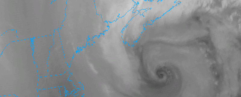
An area of low pressure which passed to our north on Sunday and provided our northern sections with some wintry precipitation is now located just to the east of the Gulf of Maine this afternoon. This area of low pressure has rapidly deepened into an impressive blizzard for parts of Maine bringing well over a foot of snow to some locations and can be seen clearly on today’s visible satellite imagery. This area of low pressure, in conjunction with a high pressure located over the Ohio Valley are producing a tight pressure gradient between the two systems which causes the air between them to accelerate rapidly and occasionally work their way down to the surface.
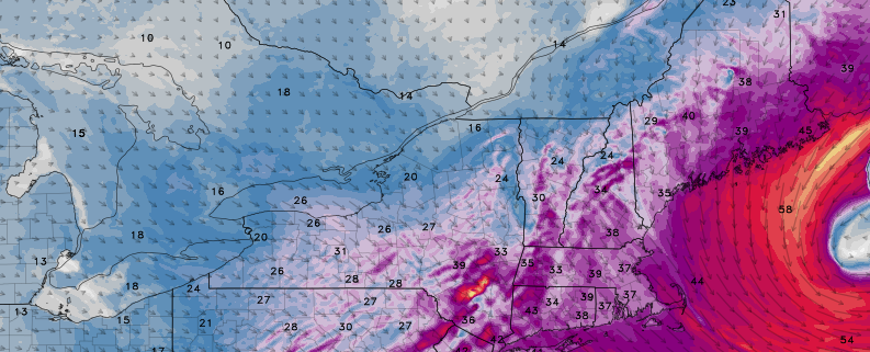
As of 1pm, the highest gusts in the immediate New York City area were White Plains, NY 72 MPH, LaGuardia 61 MPH, Stamford, CT 55 MPH, Glen Cove, NY 56 MPH, Central Park 44 MPH. These gusts should continue throughout much of the afternoon as instability increases and allows the winds above the surface to mix down from about 4,000-5000 feet above the surface. Winds of this magnitude will be able to easily blow garbage cans around, displace lawn decorations, break medium-large tree limbs, and possibly even cause localized power outages. These high winds have also prompted significant delays at local airports, with Newark experiencing over two and a half hour delays at this time. Accordingly, the National Weather Service has already issued wind advisories and high wind warnings through throughout the area.
Today will have a mixture of sunshine and clouds, with temperatures remaining mostly in the 30s. But a storm that brought a wintry mix to parts of the region on Sunday, is currently intensifying rapidly east of New England. A tight pressure gradient behind this low has caused winds to gust between 40mph to 50mph already, in some locations early this morning. Strong northwest winds will likely continue through at least early this afternoon, instability and mixing increases. These winds continue to be sustained between 20 to 30 mph with frequent wind gusts between 40mph to 50mph, through early this afternoon.
https://www.nymetroweather.com/wp-content/uploads/2017/02/Visibleimage.png600800Miguel Pierrehttps://www.nymetroweather.com/wp-content/uploads/2024/02/Empire-2000-x-300-px-2.pngMiguel Pierre2017-02-13 09:19:432017-02-13 09:19:43AM All Zones Update: High Winds Today, More Tranquil Weather Tuesday
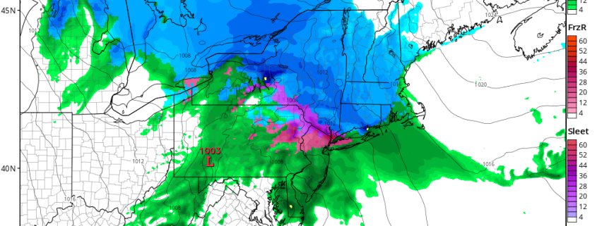
Low pressure currently over Western Pennsylvania will weaken, and as secondary low develops over Southern NJ/Delmarva. This storm system will try to push a warm front through the region. But it will likely stall south and west of NYC, as high pressure positioned over New Brunswick supports more cold-air damming with east-northeast winds over the region.
https://www.nymetroweather.com/wp-content/uploads/2017/02/nam4km_ref_frzn_neus_6.png7721024Miguel Pierrehttps://www.nymetroweather.com/wp-content/uploads/2024/02/Empire-2000-x-300-px-2.pngMiguel Pierre2017-02-12 11:14:052017-02-12 11:14:05Late AM All Zones Update: Snow & Ice Continues For Some Areas This Afternoon
Hi friends! Our website uses cookies to provide an optimal browsing experience for you. New "Cookie Consent" laws mandate us to inform you of this. As long as you're cool with it, just hit OK. You'll only see this message once.
We may request cookies to be set on your device. We use cookies to let us know when you visit our websites, how you interact with us, to enrich your user experience, and to customize your relationship with our website.
Click on the different category headings to find out more. You can also change some of your preferences. Note that blocking some types of cookies may impact your experience on our websites and the services we are able to offer.
Essential Website Cookies
These cookies are strictly necessary to provide you with services available through our website and to use some of its features.
Because these cookies are strictly necessary to deliver the website, refusing them will have impact how our site functions. You always can block or delete cookies by changing your browser settings and force blocking all cookies on this website. But this will always prompt you to accept/refuse cookies when revisiting our site.
We fully respect if you want to refuse cookies but to avoid asking you again and again kindly allow us to store a cookie for that. You are free to opt out any time or opt in for other cookies to get a better experience. If you refuse cookies we will remove all set cookies in our domain.
We provide you with a list of stored cookies on your computer in our domain so you can check what we stored. Due to security reasons we are not able to show or modify cookies from other domains. You can check these in your browser security settings.
Other external services
We also use different external services like Google Webfonts, Google Maps, and external Video providers. Since these providers may collect personal data like your IP address we allow you to block them here. Please be aware that this might heavily reduce the functionality and appearance of our site. Changes will take effect once you reload the page.
-2")