4/04 All Zones AM Update: Strong T-Storms Possible This Afternoon, Larger Storm Likely Thursday

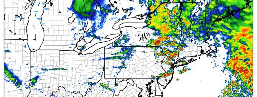
Happy Tuesday! Heavy rains from overnight have moved out most of the region quickly this morning, as best forcing with a strong low-level has shifted northeast into New England. Thus flood watches for New Jersey and Lower Hudson Valley have been cancelled, with more significant flooding no longer anticipated for today. It will remain mostly cloudy with some showers, drizzle or patchy fog the rest of morning, as a the warm front remains to the south.

Read more

PM Zones Update: Heavy Rain and Embedded Thunderstorms on Tuesday

We hope you all enjoyed this lovely Monday! This nice weather will be very short-lived as a strong storm system is approaching and clouds will rapidly increase this evening, if they had not done so already. Heavy rain with this storm is likely after midnight tonight and into Tuesday morning, with perhaps a lull in the action followed by scattered thunderstorms in the afternoon.

This is the same storm that has brought tornadoes to the Southeast US and it has an extremely impressive moisture feed from the Gulf of Mexico and Caribbean. The core of the storm will be moving into the Central US and into the Great Lakes, but our placement well out ahead of the storm considering its expansive moisture feed actually places us in the area for heaviest rainfall. This is because the east side of these systems have the strongest wind fields; and in this case the strongest low-level jet for further moisture transport. Additionally, lift will be fueled by a warm front that will be pushing into our region ahead of the storm as well.

Read more

Active pattern continues, impactful late week storm

Happy Monday! Amongst other things, Monday means it’s time for our public post, in which we detail the upcoming weather pattern throughout the country and how we expect it to evolve. The past few public posts have honed in on the development of a very active weather pattern throughout the country, and this will be no different. Multiple storm systems are traversing the United States this week and will each produce their fair share of impactful weather.

The first is already occurring, as severe weather and unsettled conditions spread from the South/Central United States into the Southeast states today. This very same storm system will spread unsettled weather into the Eastern United States and Northeast on Tuesday, bringing periods of rain with it – and the outside potential for thunder in some areas as well.

Read more

4/03 All Zones AM Update: Heavy Rain, T-Storm, Flooding Potential Late Tonight and Tuesday

Happy Monday! Pleasant weather continues today as high pressure slides offshore this afternoon. Some mid and high level clouds will make their presence known as the day goes on, but sunshine will filter through the clouds until at least the late afternoon hours. This will help temperatures rise into the lower and middle 60s over much of NJ, NYC and even parts of the interior.  A light southeast wind may keep high temperatures in the mid and upper 50s closer to the shores, including Long Island.

Read more