-2")
Southeast Ridge Builds, But Not For Long…
Good evening!
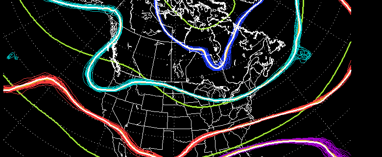
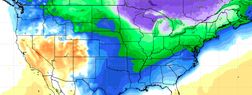
Today was another relatively mild day with some decent mid-upper level cloud cover that faded throughout the day as a weak disturbance to our south quickly moved eastward. High pressure over central and eastern Canada remains in control of the weather over much of the northern tier of the United States and has prevented the northward progression of the weak disturbance over the southeast US. This same high pressure system has also ushered in a colder airmass into the mid levels of the atmosphere, with the surface temperatures lagging behind. This lag-time between the surface and mid levels has allowed highs today to reach into the lower to middle 40’s across much of the New York metro area, with some locations in southern NJ reaching into the upper 40’s. As the evening goes on, we should see clouds continue to decrease in earnest, with only a few high cirrus clouds sticking around through the night as dry air continues to sink into the Northeast. With the relatively clear conditions expected, a renewed source for cold air, and light winds, conditions this evening will become quite favorable for radiational cooling to occur over the entire Northeast. We should see lows drop a good 15-20 degrees, with readings getting into the middle to upper 20’s across most of the metro area. Low 20’s and possibly teens will also be acheiveable to the north and west of the city due to excellent radiational cooling conditions in the valleys of NY state.
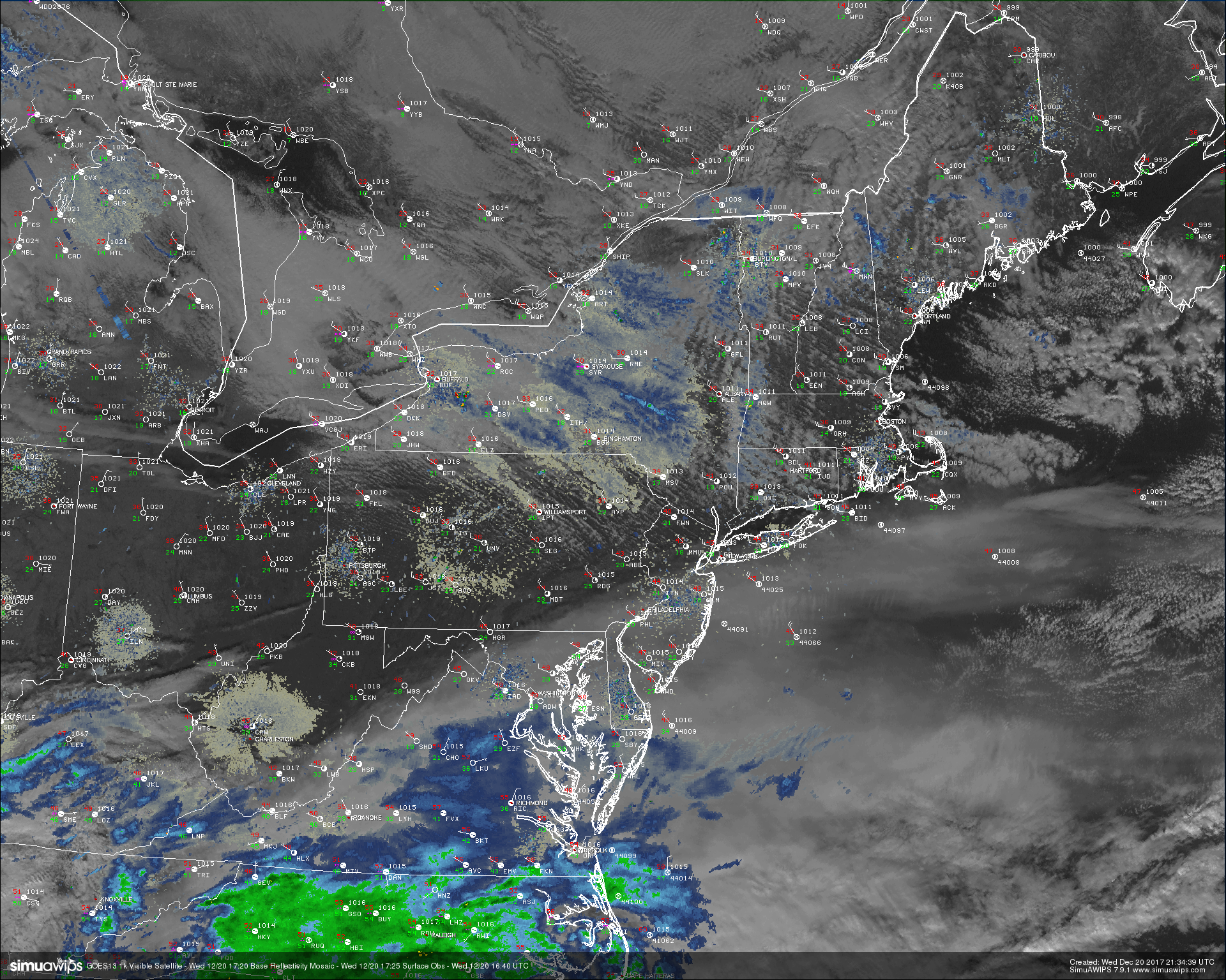
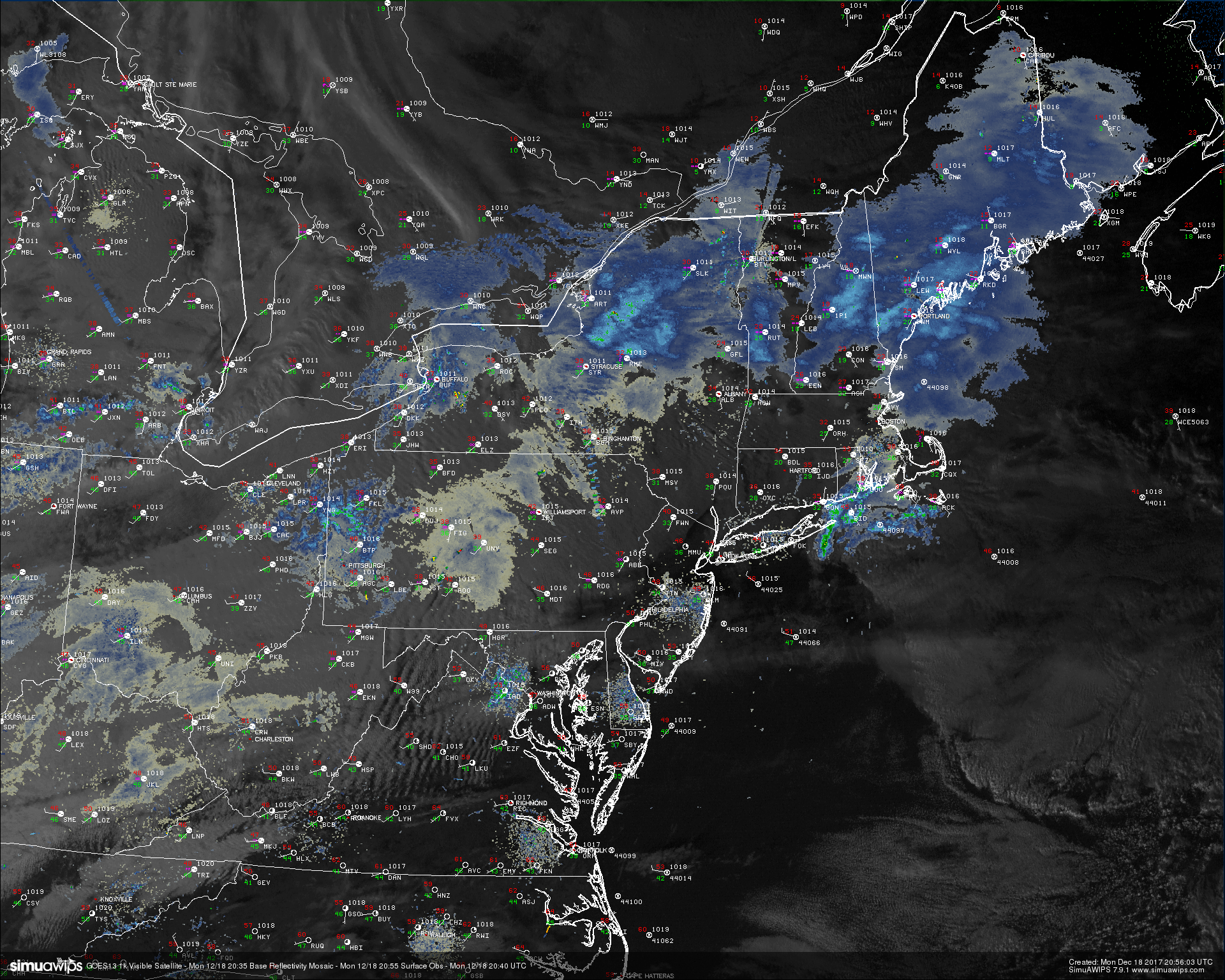
Snapshot of todays weather across the Northeast with regional radar mosiac, surface observations, and 500-meter high-resolution visible satellite data from GOES 16. Note the sharp cutoff of cirrus clouds just to the south of NYC
Thursday Into the Holiday Weekend
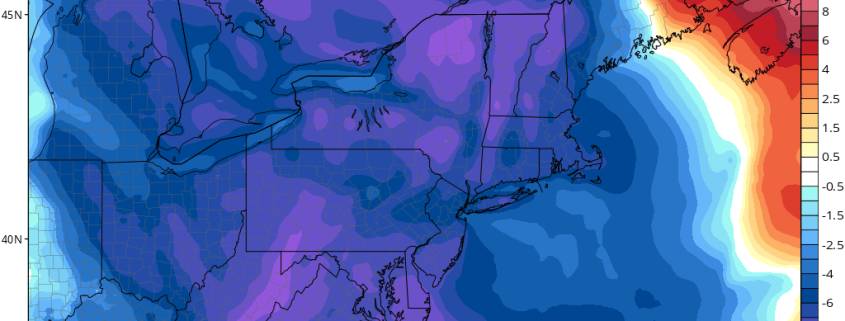
Thursday looks to start off rather cold and clear as high pressure to our north remains in control of the weather. Temperatures during the morning commute will likely start off in the middle to upper 20’s, but as the day goes on tomorrow we should see clear skies and light northerly winds result in highs heading into the lower to middle 30’s, with upper 30’s to lower 40’s possible across southern New Jersey. Downsloping winds will cause of good amount of subsidence over the region tomorrow, so expect generally dry and clear conditions for the vast majority of the day. As we head into the evening hours tomorrow, ridging ahead of a growing system out in the plains will cause heights to rise over the East, which should bring an increase in mid level moisture. Clouds should gradually increase as darkness falls tomorrow, likely becoming mostly cloudy as the night progresses. With the increase mid level heights will come a more stout southwesterly flow over the region, which will work to increase mid level temperatures. Despite a marked increase of about 5-10 degrees in the mid levels, the high pressure to our north will continue to pump colder surface air into the Northeast. This more-dense cold air should win out against any potential warm air intrusions Thursday night, so look for lows to range in the middle to upper 20’s once again, with warmer lows in the 30’s expected to the south and west.
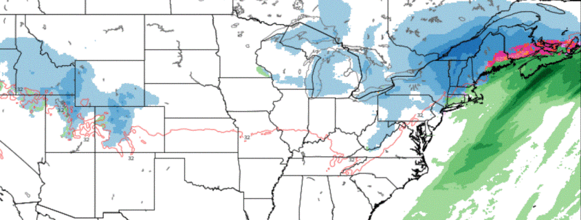
By Friday morning, we should see a significant amount of energy in the desert southwest that should help to pump the much-talked-about “southeast ridge” over the southeast. Moisture will begin to stream in over the ridge on Friday and pool ahead of a slow-moving cold front over the Tennessee valley. Southwest flow will increase throughout the day on Friday, leading to increasing temperatures and a threat for showers during the day. It is important to note that some of the precipitation at the onset of this system may actually be in the form of sleet/freezing rain/snow across locations to the north and west of the city due to stubborn low level cold air trying to hold on. Depending on how much this cold holds on, we could see a period of a light wintry mix into the early afternoon which may cause for slippery travel conditions. Regardless, expect much of the day to be unsettled with cloudy conditions and a chance at showers. Highs will be slightly warmer over the area on Friday, with temperatures in the 40’s expected for much of the Northeast.
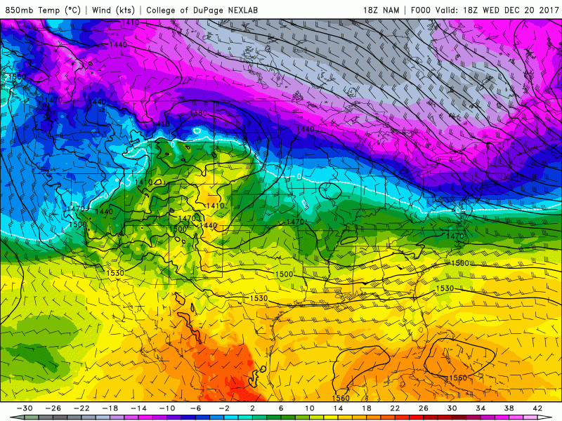
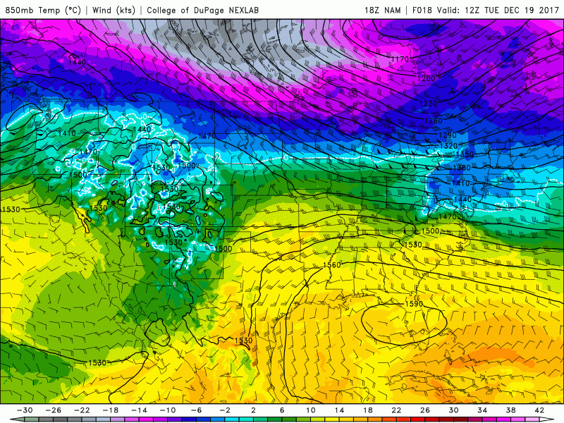
This afternoons NAM model showing the building mid level ridge over the central part of the country, followed by a large supply of Polar air developing over southern Canada.
Holiday Weekend Outlook and Beyond!
More rain steady rain is likely for Saturday and into Sunday before things clear out on Sunday morning. A large piece of Pacific energy will be carving out a trough in the central United States that will work to pick apart the southeast ridge. A polar airmass will then flow into the back end of this trough, which should create a tight gradient between the warmer SE ridge and the cold over the Plains. The models begin to differ late on Christmas eve when a low pressure may develop over the Tennessee valley. This afternoons European model has trended colder and more to the south and east with this low, and would bring a rather significant snowfall on Christmas day as the low rides the temperature gradient, then quickly strengthens. Some of the other model guidance places this initial temperature boundary a little farther south, which causes the bulk of the system to ride out to sea with little fanfare for the Northeast. While the details still need to be worked out quite a bit, condition’s on Christmas are looking to be colder than originally forecast with the potential of a wintry day across the Northeast. This will be looked at much closer on Friday when most of the model guidance will be in their more-reliable range.
By Tuesday, we should see the polar cold begin to bleed into the Northeast as a large high pressure system takes over much of the eastern US. This cold will be setting the stage for a potentially wintry end to 2017 as the medium range models are beginning to sniff out a potential system arriving on the west coast by next Wednesday. There will be the potential for another Polar airmass to invade the country, with a massive high pressure system over much of southern Canada. This high pressure system over Canada would then lead to any potential system developing in the Plains states to ride generally east. This kind of track would allow precipitation to break out over a large portion of the country as moisture streams northward from the Gulf of Mexico. With Continental Polar air filtering into the Northeast, there would be a heightened threat for snow as we draw closer to the 12/27-12/31 time frame. We will also be keeping a very close eye on this period over the next couple of day and provide updates when they’re available.
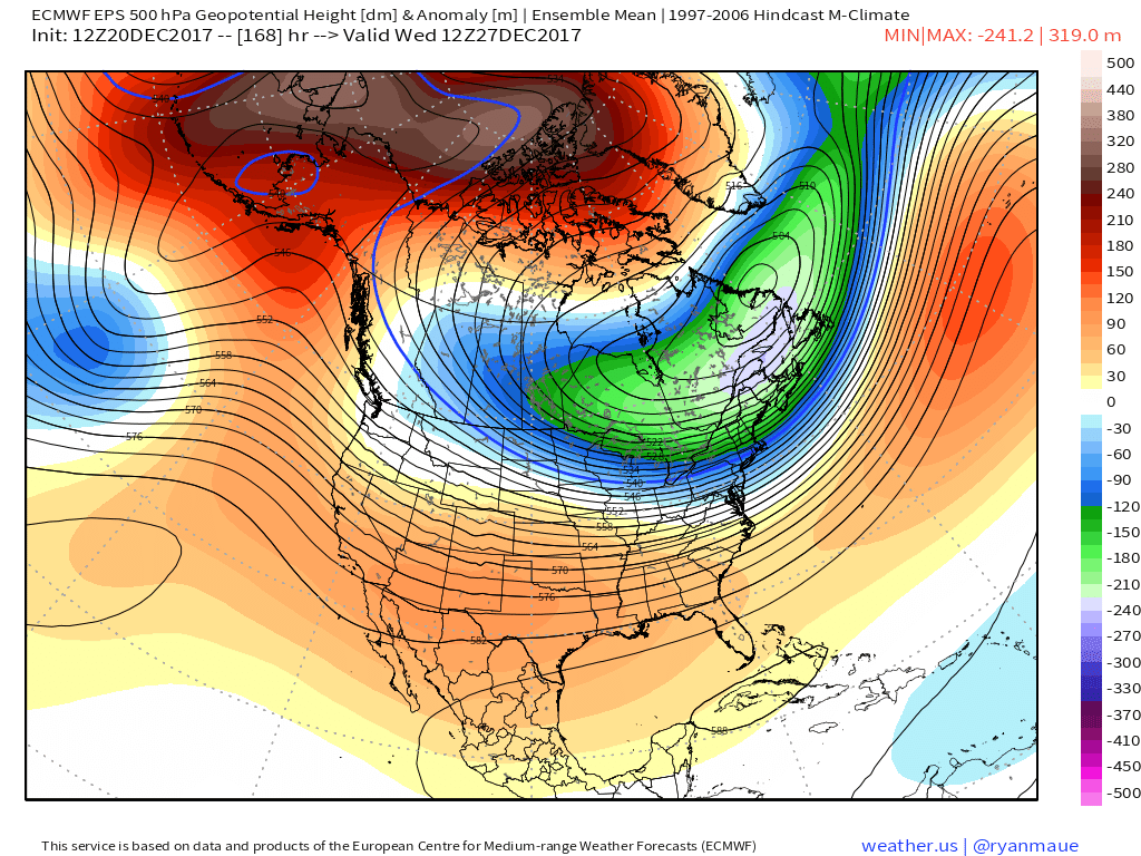
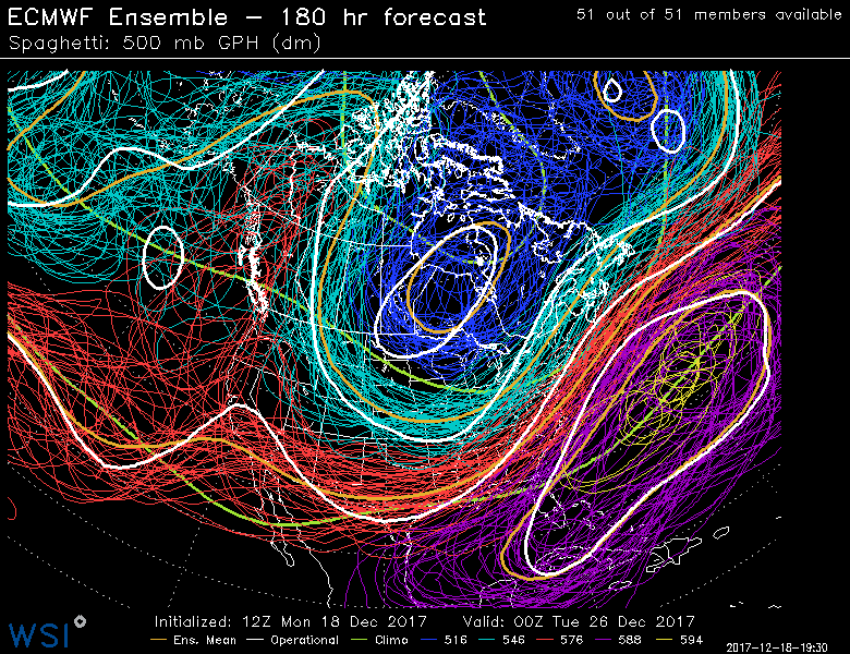
This afternoons European Ensembles showing a potentially cold and active period coming in the next 10-15 days as mid level ridging increased over the Arctic regions.
Stay tuned for further public updates! . Also join us at 33andrain forums for free discussion on everything weather-related.
Have a great night!