First Widespread Snowfall of the Season Likely Saturday!

Good Evening Folks! 

Well the close-call we warned you about on Monday has trended much closer to the coast over the past 48 hours, and looks to deliver the first light to moderate snowfall for many locations long the I-95 corridor! The setup for this storm has been a cold one, as a weak area of high pressure attempted to build over the Mid Atlantic states this afternoon. This area of high pressure has brought a more substantive portion of the Arctic airmass that lies just to our north, and this could certainly be felt today as the air had more of a “bite” to it. This Arctic air is also noticeably more dry than the previous stale airmass that has been in place, and will play a role in the snowfall forecast for tomorrow. Regardless, today’s highs were a bit colder than the past few days due to the reinforcement of the colder air and some mid to high level clouds streaming in overhead. The vast majority of the Northeast saw highs in the lower to middle 30’s, with middle to upper 30’s closer to New York and Philadelphia. This is just below normal for this time of year, and should be the norm for the next couple of days.

As we head into the evening hours, skies should remain mostly cloudy as more mid to low level moisture streams in thanks to a stout mid level jet transporting rich tropical moisture northward. As I mentioned earlier, there is a good amount of dry air in the mid to lower levels of the atmosphere, this should hold off the snow until the very early morning hours of Saturday. Locations farther south in portions of New Jersey may see an earlier start time due to more available moisture. In fact, Cape May New Jersey is currently seeing moderate snow, but this may be due to a moist marine airmass in that area. Overall, expect the mostly cloudy conditions to continue overnight, with lows likely dropping into the upper 20’s and lower 30”s across much of the New York city area. There is the possibility that the dry air will not be able to hold on for as long as the models expect, and portions of New Jersey, Maryland, Delaware and Pennsylvania could see some light snow before sunrise. Only light accumulations around a trace to two inches would be expected if this were to occur.
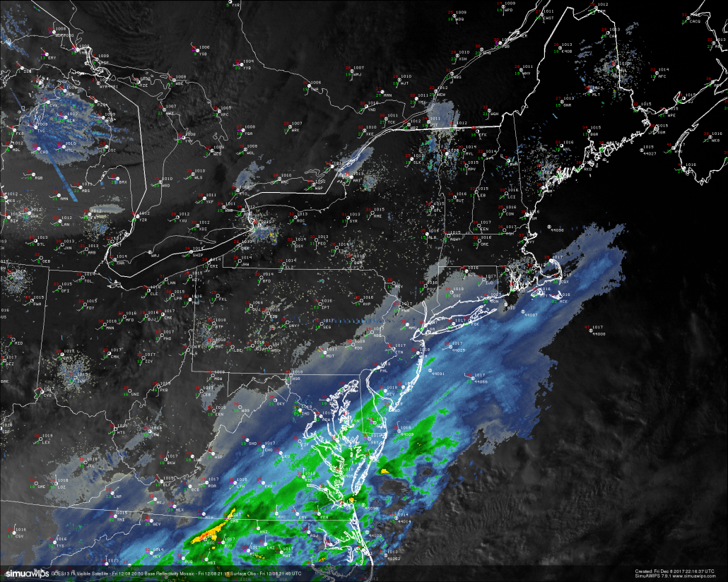
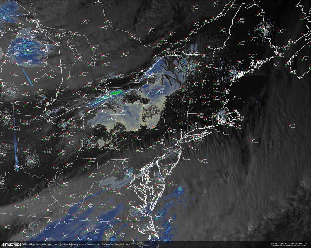
This evenings last-light visible satellite imagery, surface observations, and regional radar showing precipitation starting to work north into the Northeast.

This evenings last-light visible satellite imagery, surface observations, and regional radar showing precipitation starting to work north into the Northeast.

 Moderate Snowstorm Likely Saturday

The massive area of tropical moisture that we talked about back on Wednesday has certainly left its impact across the south over the past 36 hours, with snow being reported in all of the Gulf Coast states except for Florida. This system is being aided by a very strong and anomalous upper level jet streak overhead, which is working to promote the development of intense precipitation over the southeastern states. This system is not the only player for our storm tomorrow, as we have also been tracking an energetic piece of energy diving down from the far northern regions of Canada. As this system continues to move south and into the Great Lakes region, it will begin to interact with the system over the southeast and begin to create a favorable environment for the development of a coastal low to form just off the southeast coast. As this low continues to take shape and the two systems begin to interact further, we should see the bulk of the precipitation begin to move north and expand quite a bit over the Northeast by the early tomorrow morning. This expansion of the precipitation was something that was not well-handled by the models a couple days ago, and is likely to due to the very strong upper level jet streak aiding to the development of precipitation over the area. Snow should start from south to north tomorrow morning, and eventually making its way into the NYC area by 11am or so.
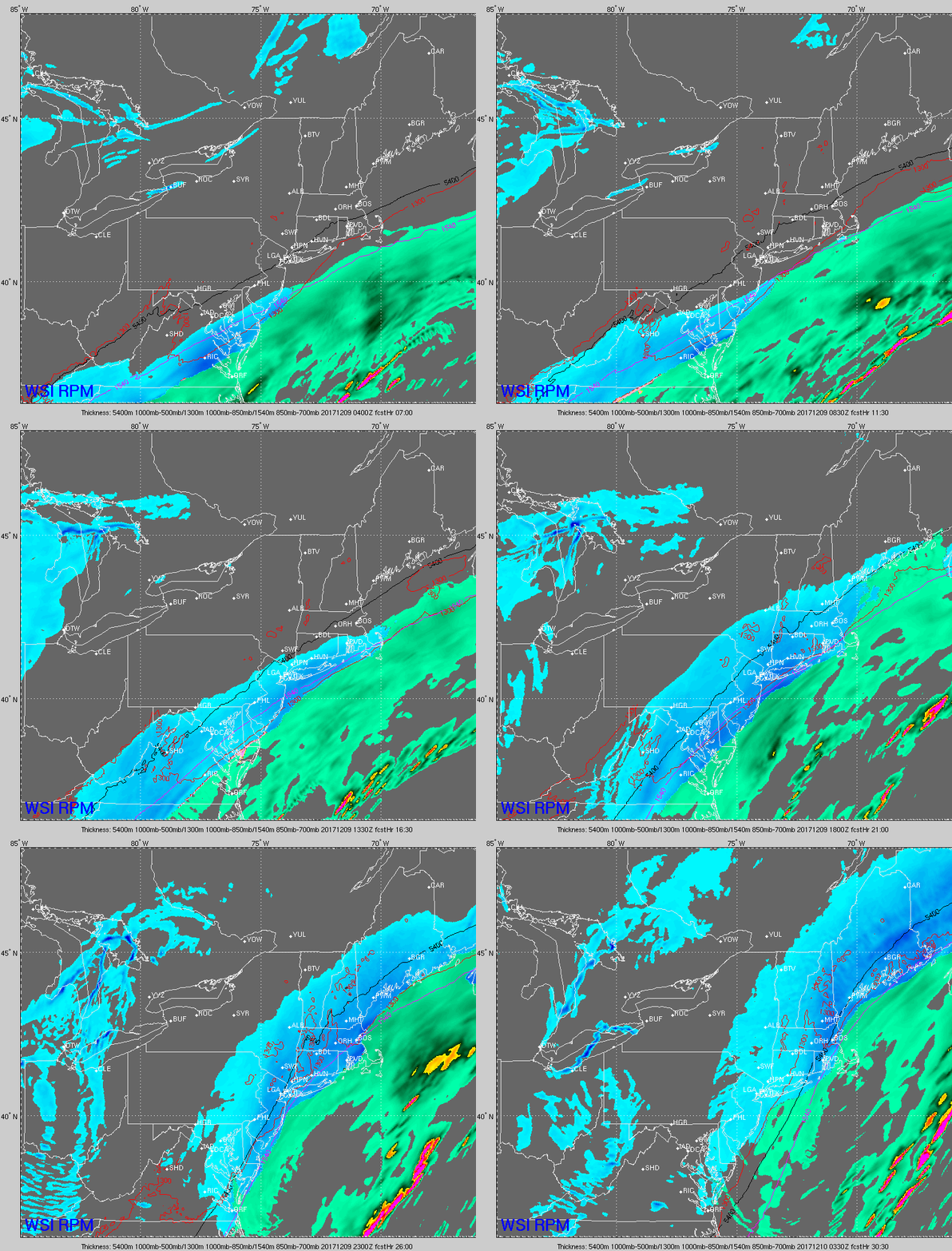
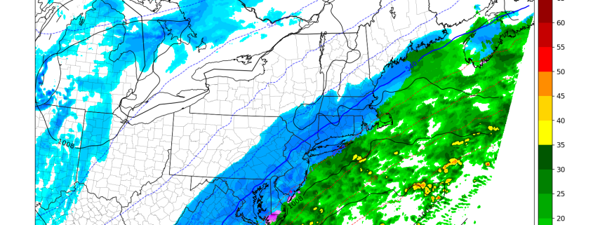
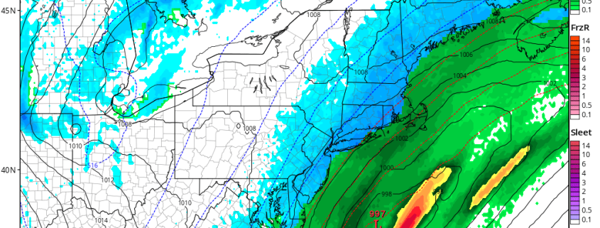
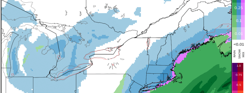
This evenings latest RPM model showing the potential evolution of tomorrows snowstorm across the Mid Atlantic and Northeastern states

This evenings latest RPM model showing the potential evolution of tomorrows snowstorm across the Mid Atlantic and Northeastern states

We may see a period tomorrow morning where the radar looks to have snow over certain locations, but nothing is actually falling at the surface. This is due to the dry air in the mid to low levels of the atmosphere that  causes snow to evaporate before it reaches the ground, but the radar beam still detects it when its far above the ground. This dry air will likely give way once the coastal low begins to intensify off of the Carolinas late tomorrow morning and into the afternoon hours. Expect the snow to start off rather light during the onset, but transition to a more steady rate for the duration of the storm. Portions of eastern New Jersey, southern New York, Long Island and Connecticut may see a few hours of heavy snow, with rates possibly nearing .5″-1″ an hour. Snow should continue through the late afternoon hours and into the evening, before tapering off from southwest to northeast during the early morning hours on Sunday.

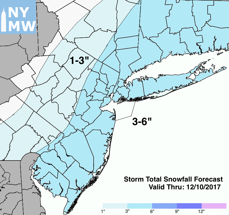
As of right now, we are expecting a large swath of accumulating snow totals around the 3-6″ range from southeastern Pennsylvania, through most of New Jersey, and into New England. There may be localized amounts greater than six inches, but this may be confined to southern and eastern portions of the area where heavier snow bands may set up. Road conditions will likely be quite messy tomorrow as the snow is likely to create slippery conditions as it begins to ramp up in intensity. Travel may become hazardous during the afternoon hours during the peak of the storm, so it may be a good day to stay inside and get some work done and stay off the roads unless necessary. We will have updates on this storm after this evenings model runs come in as well as throughout the day tomorrow!

Storm total snowfall forecast

Storm Total Snowfall Forecast Map

Stay tuned for further public updates!. Sign up for our Enterprise Forecasts for more frequent or tailored updates, technical analysis, videos and long range discussion. Also join us at 33andrain forums for free discussion on everything weather-related.

Have a great evening!

-Steve Copertino 

First snowfall of the season for the Northeast this weekend

About two weeks ago, it became clear that the weather pattern was set to undergo a significant shift. After many weeks of warmth, a reshuffle was underway in the Pacific Ocean, and the downstream effects of this would lead to colder air with a more wintry pattern in the North-Central and Northeast United States. Two weeks and many forecasts later, here we are. The first snowfall of the winter is set to fall in the Northeast states this weekend, including the metropolitan areas of Philadelphia, New York City, Hartford and Boston.

Forecast models, for all of their benefits, were not keen to signal the potential for snow this weekend until about 24 hours ago. Forecasters had been monitoring this potential quite closely, but a snowfall of any significance always seemed like a long shot in the Northeast States. On Thursday morning, however, it became clear that a significant trend was underway, and forecast model guidance quickly began changing the evolution of the storm system during the weekend ahead.

Read more

First Accumulating Snow of the Season Becoming Likely for the East Coast

Good afternoon! In the world of weather, there has been a lot of model mayhem regarding a big shift in the data further northwest with a coastal storm, which is leading to the idea of accumulating snow across much of the Eastern US on Saturday. We believe that these ideas have a lot of merit, and in this article we are going to explain why, as well as overview some of our expectations.

In the macro sense, it’s not a complicated setup. We have a large ridge in the West, and a corresponding deep trough in the East, we have disturbances sliding down the ridge and entering the trough, and we also have a relatively stalled frontal boundary off the coast, providing a strong temperature gradient for a storm to ride, while also providing enough ridging in the Atlantic to keep the storm from sliding out to sea.

Read more

Changes Blowing Through the East, Active Pattern Looming Next Week

Good Evening! 

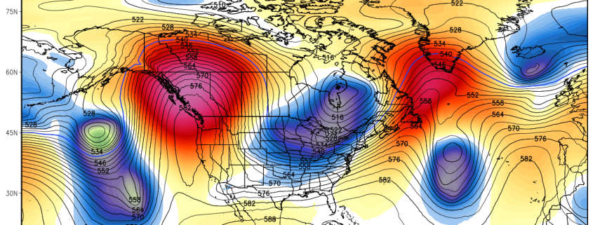
Well, we have been talking about the pattern change for around two weeks now, and things have transpired according to plan across much of the Northern Hemisphere. We have a massive area of ridging set up over the West Coast that has caused record high temperatures as well as wildfires across California. Our second area of ridging has taken shape over Greenland and both of these features have led to a deep trough digging into the central US and east, which we’ll discuss in further detail in just a bit. Today was a cooler and calmer day across the entire Northeast after the passage of a rather large cold front that moved through yesterday evening. While the immediate temperature change didn’t occur for hours, the front did bring in a new Arctic source region for our airmass for the duration of the week. This new Arctic airmass has been modified somewhat was leftover Pacific air, but partly cloud skies and cooler temperatures aloft allowed highs to only get into the upper 30’s and lower 40’s this afternoon, with some slightly warmer readings closer to the coast. The main story behind this front was the dramatically decreasing dewpoints across the entire Northeast, signalling the arrival of a dry continental polar airmass. Additionally, winds were a bit gusty this afternoon, on the order of 15-20 miles per hour, which certainly added to the winter chill in the air. Calm conditions should continue throughout the evening, with light winds from the southwest taking over. Despite the southwesterly winds, cold air advection is expected over much of the area, with decent conditions for radiational cooling to take place. Overall, expect a rather chilly night with lows in the upper 20’s and lower 30’s near the New York City metro, and lower to middle 20’s further to the north and west.

Last light GOES13 visible satellite imagery, regional radar mosaic, and surface observations, showing calmer and cooler conditions taking over the Northeast. Some high to mid level clouds are possible later this evening (Credit Simuawips)

Last light GOES13 visible satellite imagery, regional radar mosaic, and surface observations, showing calmer and cooler conditions taking over the Northeast. Some high to mid level clouds are possible later this evening (Credit Simuawips)

Thursday and a Close-Call On Friday 

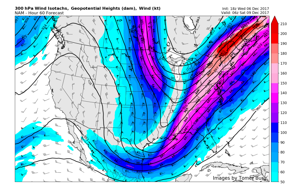
The large area of trofiness will continue to dig into the central and eastern portions of the US tomorrow morning, allowing a massive and intense upper level jet streak to work in over the Northeast. This jet streak may provide some high level clouds tomorrow, but the majority of the active weather will likely stay over portions of the deep south and Gulf of Mexico throughout the day. Conditions should be mostly sunny tomorrow with light subsiding winds, so expect near-normal temperatures across the area, with highs likely reaching into the upper 30’s and lower 40’s. This should be right around normal for this time of year. These calm conditions will likely remain throughout the day as a secondary jet streak to our north creates large-scale sinking air over the Northeast. Temperatures Thursday night should be able to fall a little steeper this time around, with lows likely dipping into the middle to lower 20’s across much of the Northeast, with locations farther north and west likely seeing upper teens and lower 20’s for lows, which will be a good bit below-average.

As mentioned, things become a bit more interesting on Friday as the same upper level jet-streak begins to intensify as energy from the deep-south begins to quickly head north as the trough over the eastern third of the country begins to tilt. This tilting will cause the jet streak over the east coast to retrograde , or head westward throughout the day on Friday. Some more high level cirrus clouds are expected during the day, with another shot of cold air in the lower levels also likely. This should allow highs over the region to remain in the middle to upper 30’s, with locations closer to the coast likely hitting the 40-degree mark. The aforementioned strong upper level jet streak will work with copious amounts of energy just off the east coast to produce widespread precipitation along a frontal boundary.

This evenings NAM model showing a very impressive and intense jet streak over the Northeast, promoting the development of precipitation near the east coast (Credit: Tomer Burg)

This evenings NAM model showing a very impressive and intense jet streak over the Northeast, promoting the development of precipitation near the east coast (Credit: Tomer Burg)

This frontal boundary could have a wave of low pressure develop along it that may allow precipitation to affect portions of the coast, and possibly into the NYC area. Model guidance has been going back and forth with this frontal system, showing light to moderate precipitation over the area on one run, just to show virtually of the precip off the coast on the next. At this time, we think that there is a decent chance that far eastern locations near the coast (especially Long Island) may see some light snow out of this frontal system. Depending on how things transpire over the next day or so, there is a rather low risk of accumulating snowfall west of central Long Island, but I wouldn’t be surprised to see some snow falling across the lower Hudson valley on Friday night, as many of these weak frontal systems with strong jet-stream energy tend to tick north and west in the last 24 hours. We will certainly be monitoring this system over the next two days and will provide updates when necessary!

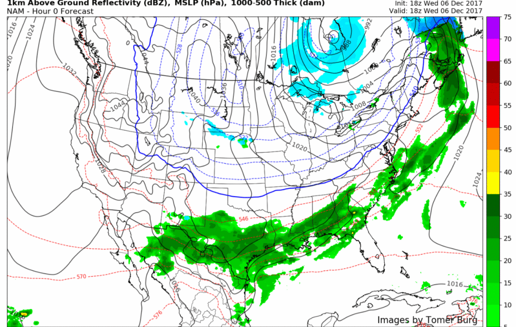
NAM simulated radar imagery showing the potential evolution of the system on Friday/Saturday

NAM simulated radar imagery showing the potential evolution of the system on Friday/Saturday

Potentially Active Period Next Week

With the massive ridging over the west, deep trough in the central/eastern US, and limited blocking over Greenland, we could be looking at the potential for a few light snow events over the next week. The first would be possible on Sunday as the upper level low from the storm system on Friday begins to rotate over the region. Only snow showers would be possible with this system, but we should lake effect snow increase quite substantially from this system as cold low level air moves over the still-warm lakes. The next chance for something of substance would be on Tuesday as a large amount of energy dives down from Canada and into the base of the trough over the east. The models have been extremely inconsistent with the handling of this piece of energy, but it seems that this system may try to phase with a very strong upper level low over the Great Lakes region, which would promote a storm developing just to our south or over our region. At this time, there is no support for a sizable storm, but with a setup like this and a good deal of energy involved, its always good to watch these systems as they come down from Canada. Lastly, we look at late next week and into the weekend when more energy begins to dive down from Canada. This energy may have a better shot at successfully phasing with that same strong upper level low over the Great Lakes, but it will be a couple of days before this potential system comes into the reliable range of the computer model guidance. With an active period shaping up for the rest of December, remember to check back for updates as they come out!

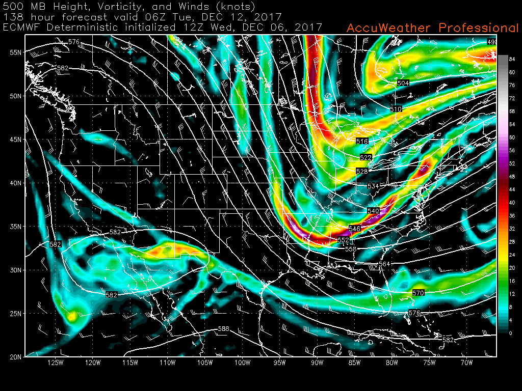
This afternoons European model showing a good amount of energy diving into the base of the trough located over the east. This setup needs to be watched for a late-developing storm near our area next week

This afternoons European model showing a good amount of energy diving into the base of the trough located over the east. This setup needs to be watched for a late-developing storm near our area next week

Stay tuned for public updates later this week. Sign up for our Enterprise Forecasts for more frequent or tailored updates, technical analysis, videos and long range discussion. Also join us at 33andrain forums for free discussion on everything weather-related.

Have a great evening!

-Steve Copertino