Not just scud: It was a wall cloud over Nassau county Tuesday

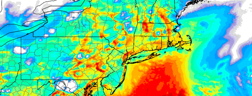
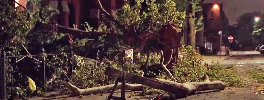
Tuesday evening, strong to severe thunderstorms moved through Eastern New Jersey and towards New York City. In fairly typical fashion, they also proceeded eastward toward Western Long Island before emerging into the Atlantic waters and weakening. The storms were particularly intense in terms of lightning, and even produced some strong wind gusts throughout the New York City Area. Unfortunately, three people were struck by lightning in the 5-Boros. We are awaiting further information on their status, but all three have been hospitalized.

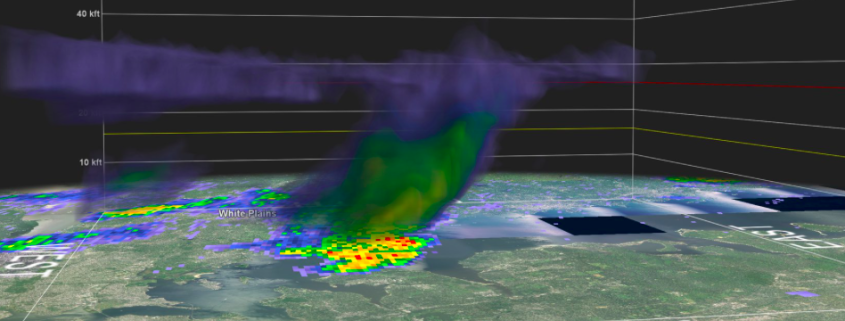
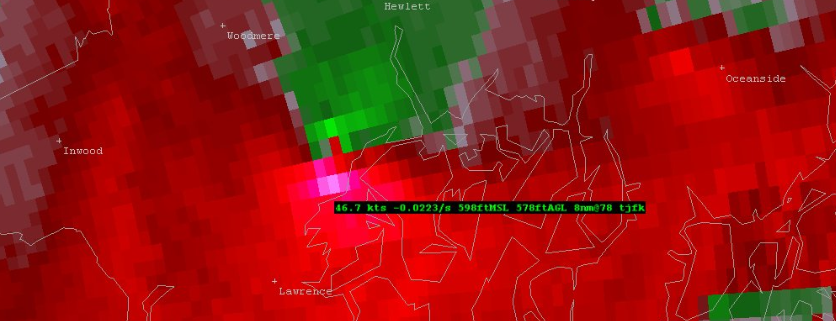
Also notable was a brief area of rotation in one of the stronger storms over Queens and Nassau counties. If you weren’t paying close attention, you may have missed it. In fact, even using Doppler radar out of Upton, NY (KOKX) or Mount Holly, NJ  (KDIX) wouldn’t necessarily have keyed you in to the rotation. But a zoom into Terminal Doppler Radar Data (TDWR) out of JFK Airport revealed something more interesting.

Read more

NYC Area Forecast: Additional strong storms possible later today

Strong and severe thunderstorms moved through parts of the Northeast states on Tuesday evening, producing frequent and dangerous lightning as well as strong, gusty winds and torrential rain. There was even a wall cloud spotted in Queens and Nassau counties, as an area of distinct rotation appeared on terminal doppler radar out of Kennedy Airport. This was the third instance of rotating thunderstorms in the NYC area in just over a week.

The threat for strong thunderstorms will continue today as a frontal boundary slowly sinks towards the region. Instability is expected to build once again by this afternoon across the Northern Mid-Atlantic States with ample heating and a continued source of moisture (you may have noticed that it is very humid outside). As better forcing for storm development approaches later today, thunderstorms are expected to increase in coverage once again.

Read more

NWS confirms tornado in Queens

The National Weather Service has confirmed an EF0 tornado in Queens on Thursday evening, with winds of 85mph and a path of 0.7 miles.

A Tornado Warning was issued last night at 10:18pm by the National Weather Service, a few moments after strong rotation appeared on the Terminal Doppler Radar out of Kennedy Airport in Southern Queens.

Read more

NWS to investigate possible tornado in Queens last night

A Tornado Warning was issued for Queens on Thursday evening shortly after 10:00pm, and the National Weather Service will head there this afternoon to investigate the possibility of tornado damage. Local terminal doppler radar showed the presence of a notable couplet, or signal for rotation, moving through College Point around 10:15pm.

Read more