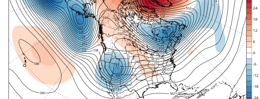
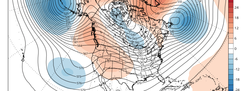
Since the breakdown of stratospheric polar vortex more high-latitude blocking has become common the last few weeks. Model and ensemble guidance are again showing blocking returning again for next week. But will it give pattern change featuring just below average temperatures? Or will a parade of systems coming out the Pacific, cause the Southeast ridge to build more?
https://www.nymetroweather.com/wp-content/uploads/2016/04/ecmwf-ens_z500a_namer_7.png6381024Miguel Pierrehttps://www.nymetroweather.com/wp-content/uploads/2024/02/Empire-2000-x-300-px-2.pngMiguel Pierre2016-04-20 20:36:572016-04-20 20:34:44(Premium) Will High-Latitude Blocking Bring Chilly Temperatures and More Rain Next Week?
After much warmer than normal temperatures during March, April has averaged cooler than normal so far, with some unseasonable cold weather for some days. This weather might seem bit ironic since we’re moving further into the Spring season. Some major league baseball games have to been postponed due to more unseasonably cold weather and even wintry precipitation in Northern parts of the nation. There are signs of a warming trend going into this weekend and early next week. But there are signs that this may be interrupted again due largely to high-latitude blocking.
Later this week, a large, deep cut-off low over the Rockies will cause a strong ridge to build over the Great Lakes and Ohio Valley regions. Another cut-off low will form on the downstream side of the ridge, off the East Coast. Initially, model guidance showed this cut-off low backing towards the region and affecting our weather this weekend. But high-latitude blocking weakening this week allows this low to remain farther offshore.
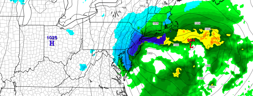
While the calendar has pointed to Spring for several days, the weather pattern has not cooperated. This weekend will be no exception. Forecast models have come into better agreement over the past few days regarding the eventual development of a low pressure system off the Mid Atlantic coast, which will form as a result of a powerful mid level atmospheric disturbance dropping southward from Canada into the Great Lakes and Northeast.
A low pressure system is likely to develop from the Ohio Valley into the Mid Atlantic and off the coast of New Jersey. Precipitation is likely to develop on the northern end of the storm system, as moisture pushes northward from the low pressure area. This will allow for bands of precipitation to develop towards our area, likely falling as rain. The antecedent airmass is quite warm, and likely supports rain over any frozen precipitation, with melting of snowflakes occurring in the lower levels of the atmosphere. However, there is one main caveat in the setup: The potential for intense banding and dynamic cooling, producing heavy snow over some areas.
https://www.nymetroweather.com/wp-content/uploads/2016/04/Screen-Shot-2016-04-08-at-10.52.52-AM.png363876John Homenukhttps://www.nymetroweather.com/wp-content/uploads/2024/02/Empire-2000-x-300-px-2.pngJohn Homenuk2016-04-08 14:03:432016-04-09 01:21:02(Premium) Dynamic cooling may bring snow to some on Saturday
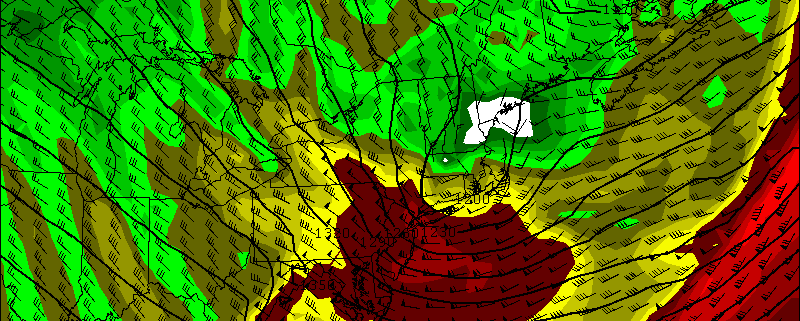
Over the past few days, we’ve been discussing on ournew hazards dashboard the possibility for high winds for late Saturday night and Sunday. As we’ve gotten closer, model guidance continues to be consistent on this event. Therefore the National Weather Service has issued a High Wind Watch for the entire region late Saturday and Sunday morning. Details are still coming into focus, but confidence is growing that this could be a very strong if not damaging wind event for parts the area.
A vigorous mid-level shortwave will amplify and cause a surface low pressure coming east out the Great Lakes Saturday night to deepen rapidly over Southern New England Sunday morning. This will create extremely low mid-level heights and thus a frigid cold pool aloft — aiding in instability and dynamics, especially when combined with the off-the-charts vorticity being shown. An Arctic front accompanying this low will also move across the region late Saturday night with some rain showers, then perhaps a change to snow showers, during late Saturday night. Steep low-level and mid-level lapse rates and total totals in 50s show enough instability for snow squalls with gusty winds and possibly even thunder.
Hi friends! Our website uses cookies to provide an optimal browsing experience for you. New "Cookie Consent" laws mandate us to inform you of this. As long as you're cool with it, just hit OK. You'll only see this message once.
We may request cookies to be set on your device. We use cookies to let us know when you visit our websites, how you interact with us, to enrich your user experience, and to customize your relationship with our website.
Click on the different category headings to find out more. You can also change some of your preferences. Note that blocking some types of cookies may impact your experience on our websites and the services we are able to offer.
Essential Website Cookies
These cookies are strictly necessary to provide you with services available through our website and to use some of its features.
Because these cookies are strictly necessary to deliver the website, refusing them will have impact how our site functions. You always can block or delete cookies by changing your browser settings and force blocking all cookies on this website. But this will always prompt you to accept/refuse cookies when revisiting our site.
We fully respect if you want to refuse cookies but to avoid asking you again and again kindly allow us to store a cookie for that. You are free to opt out any time or opt in for other cookies to get a better experience. If you refuse cookies we will remove all set cookies in our domain.
We provide you with a list of stored cookies on your computer in our domain so you can check what we stored. Due to security reasons we are not able to show or modify cookies from other domains. You can check these in your browser security settings.
Other external services
We also use different external services like Google Webfonts, Google Maps, and external Video providers. Since these providers may collect personal data like your IP address we allow you to block them here. Please be aware that this might heavily reduce the functionality and appearance of our site. Changes will take effect once you reload the page.
-2")