Long Range: Winter is Coming…January Pattern Change Details

So far this winter has been mild here with historic warmth. We released a previous premium article stating the reasons why. This is still in much dismay of snow-lovers, while a blessing to many others. But we’ve been discussing a pattern change here for January for a while, and now it appears that some parts of that pattern change are coming together a little sooner than we thought. Some of the climate patterns we discussed are going through major changes.

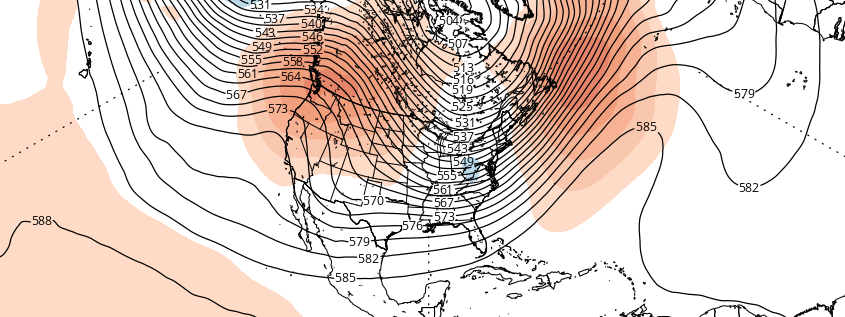
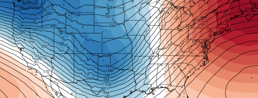
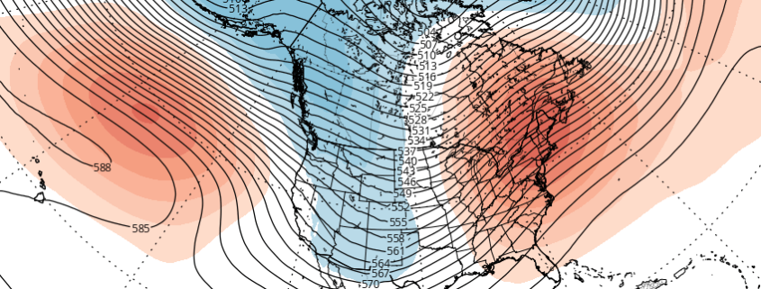
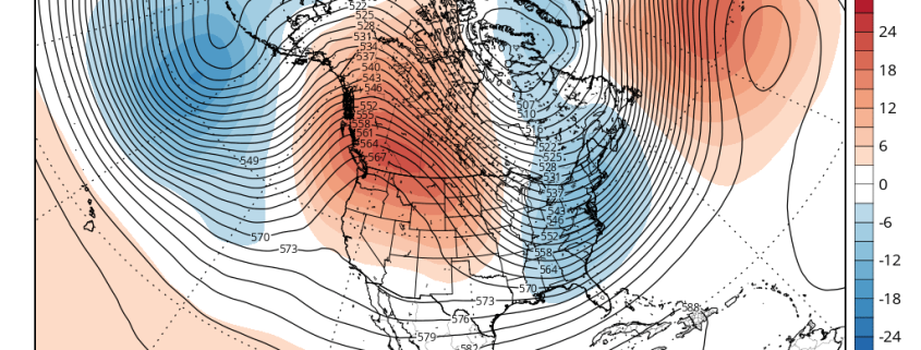
The pattern change will begin with the development of a large ridge over Scandinavia next week. This ridge builds into a very strong, anomalous ridge over the Barents/Kara Sea next weekend. Meanwhile a deep low/trough near the Aleutians causes another large ridge develop over Western Canada. Both ridges cause the polar vortex over the high-latitudes to begin elongating or splitting, from northwest to southeast. These changes will cause the AO to fall into the negative phase and the PNA to rise into the positive phase. This process results in a large trough with seasonably cold temperatures over the Eastern US shortly after New Year’s Day.

Read more

Increasing signals for a January pattern change

Meteorological winter began about three weeks ago. Over the next 10 days, it appears the pattern will be un-supportive of winter weather — and may further support record breaking warmth. But some changes maybe underway for the New Year. Our long range outlook will discuss the meteorological pattern for the upcoming 30 to 45 days. With an in depth look into meteorological patterns and the developing global circulations, we’ll explain the processes occurring that will drive our weather pattern for late this month and January.

Read more

Record breaking warmth will return Christmas week

I’m dreaming of a…Green Christmas? While there will certainly be no shortage of “White Christmas” puns in the weather headlines over the next week, the real story will be in the meteorological pattern evolving. The warmth we experienced over the past few days was impressive, and the warmth being advertised on medium range forecast models for the period around Christmas is arguably more impressive. Owing to a large trough in the West and Southwest United States, a large ridge is expected to build over the East Coast, pumping in much warmer than normal air once again next week.

Without any cold air source, or high latitude blocking, mild Pacific air can enter the region unabated. This is the same reason that record high temperatures were broken during the tail end of last week and this past weekend — southerly winds brought in mid and low level atmospheric temperatures that were highly anomalous. And it is likely the same reason that records will be broken in the period of time around Christmas.

Here’s how the pattern will shake down, and why:

Read more

Long Range: Warmth continues, when will the pattern change?

Meteorological winter began two weeks ago — but winter itself still seems to be on a hiatus. Over the next few weeks, it appears the pattern will continue to be unsupportive of winter weather — and may further support record breaking warmth. Our long range outlook will discuss the meteorological pattern for the upcoming 30 to 45 days. With an in depth look into meteorological patterns and the developing global circulations, we’ll explain the processes occurring that will drive our weather pattern for late this month and January.

Read more