2m T anomalies

Mild conditions likely next week

Good evening and happy Friday!

Today has been a much-improved, but still rather cold day across much of the Northeast. The western lobe of the troposperhic polar vortex continues to depart well off to our northeast, which has allowed the airmass in place to moderate. High pressure has been building in over much of the East Coast during the past 24 hours, which has all but eliminated any remaining windy conditions. Highs today managed to limp back into the lower to middle 20’s across much of the immediate NYC metro area, with teens being reported over elevated portions of NW NJ. Despite the continued cold, there are strong indications that conditions turn much more mild next week!

Read more

The worst of the cold is over (for now)

The periphery of a piece of the polar vortex (an important distinction) made its presence felt in the New York City area on Wednesday and Thursday, with intense snow squalls and bitter cold temperatures. The low temperature in New York City dropped to 2 F on Thursday morning, the coldest of the season thus far and the coldest since February of 2016.

The airmass will remain bitterly cold over the next 24-36 hours, as arctic air remains overhead. It will begin to shift out of the region by the weekend, however, and the airmass will feel downright tropical by the time we approach Saturday. High temperatures will swing back towards normal by that time, a far cry from the 30 or more degrees below normal which we’ve been basking in.

Read more

Surface Temps

Major cold arrives, but how long will it last?

Good Evening!

The line of heavy snow squalls that we talked about back on Monday blasted their way through portions of the Northeast earlier this afternoon. These squalls produced a quick burst of very heavy snow and strong, gusty winds that created significantly reduced visibility to just a few feet in some locations. Numerous accidents were reported across Pennsylvania, New Jersey, and New York, with a large incident involving over 40 cars in Berks County, Pennsylvania. The squalls have since moved over the far eastern portions of Long Island and will continue to head quickly to the east before moving offshore.

The main story for this entire forecast period remains to be the long-awaited Arctic front associated with the tropospheric Polar Vortex . This front will move through the New York City metro area later this evening and into the overnight hours, causing temperatures to rapidly fall. Readings will fall into the teens for the entire area this evening before falling once more into the single digits overnight-with locations off to the north and west likely getting below zero! Winds will also be quite strong behind this Arctic front, with sustained winds of around 20 mph and gusts up to 45 mph. The combination of extremely cold low temperatures and strong winds will make for some dangerous wind chills tonight. Wind chill values of -10 to -15 will be quite common for the entire forecast area, with values as low as -20 to -25 for elevated locations of NW NJ!

Surface Temps

NWS forecasted lows valid 7 AM Thursday. The circles show the potential for records to possibly be broken (WxBell)

Frigid, but calm conditions to end the week

Thursday morning will likely start off as the coldest day of the season, with temperatures in the single digits for the AM commute. High temperatures will gradually crawl back into the teens for most of the area with clear skies overhead, but wind chills will continue to make things feel more like -5F to -15F. High pressure will be building to our south during the afternoon hours tomorrow, allowing winds to gradually ease-off as we go deeper into the day. Deep northwesterly flow will continue to bring in a very dry, stable airmass over much of the Northeast leading to persistently clear skies into the evening hours. The deep “vortex” located off to our north will be gradually moving well to our north and east throughout the day tomorrow, leaving a very cold, but slightly modified airmass in place for tomorrow night. Lows will once again drop into the low teens to single digits across much of the area, which will still be well-below normal for this time of year.

Cold, calm, and clear conditions will extend into Friday as high pressure builds over the East. We may have to watch a very weak shortwave trough near the Great Lakes that will be rapidly moving to the south and east during the day. An area of light snow may break out over portions of the Mid-Atlantic on Friday afternoon, but this is expected to stay to the south of the NYC metro area-with only some increased clouds expected for our area. Highs on Friday won’t be as brutal as Thursday, with lower to middle 20’s expected for the NYC metro, and teens likely off to the north and west. Lows will fall back into the teens to single digits once again on Friday night, making for a rather cold end to the week.

Surface temperatures

Loop of the high resolution NAM model showing the progression of dangerously cold temperatures through Thursday

Much warmer conditions take hold next week

A significant warm-up seems to be in the cards as early as Monday/Tuesday as another storm system off to our west cuts into the Northern Plains. Like the numerous storm systems that have done so this winter, this system will cause deep southwesterly flow to overspread the area. This will bring a return to highs in the lower to middle 40’s as early as Monday, with highs possibly getting into the 50’s by Tuesday!

The “warmer” pattern will be in place at least through the middle of next week as yet another strong Pacific disturbance carves out a trough in the West, leading to a large area of mid level ridging over the East Coast. At this time it appears that the threat of any major precipitation events are quite low, but there are some indications that conditions will turn wet by Wednesday/Thursday with another system cutting well off to our north and west.

500mb Anomalies

This afternoon’s ECMWF run showing a deep trough located over the west and building ridge over the East. Such a pattern would favor a return to above average temperatures in the East

We’ll have an update on Friday taking a look at this weekend!

Have a great night

-Steve Copertino


Light snow likely Tuesday, frigid conditions arrive Thursday

Good evening!

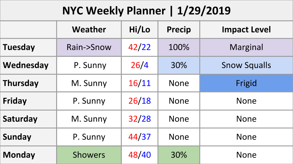
Today has been a rather calm and seasonably cold day across much of the Northeast as a weak area of high pressure located to our north remains in control of our sensible weather. Spotty upper level clouds associated with a quick-moving shortwave trough moved through the southern portions of the area earlier this morning and into the afternoon hours, but quickly gave way to mostly sunny skies. Mostly clear skies and residual northwesterly flow aloft allowed highs this afternoon to stay in the upper 20’s to lower 30’s-with the vast majority of the region staying below freezing. High pressure to our north is expected to quickly move to the east through this evening and into the overnight hours. Surface flow will gradually begin to shift from the north/west, to a more southerly/southeasterly component during the overnight hours, which will help to increase cloudiness over the area. Overnight temperatures will likely be able to fall a few degrees, with readings likely staying in the lower to middle 20’s for the majority of the immediate NYC area.

Weekly Planner

~Updated Weekly Planner~

Light Snow Likely North and West of NYC Tuesday

Our attention shifts to the Great Lakes region by tomorrow morning as an area of mixed precipitation along a cold front will be moving quickly to the east towards our area. The overall setup has become much less impressive since our last update, with only light snow accumulations expected well to the north and west of the immediate NYC area. Surface winds tomorrow morning will be out of the south and east, which will help to warm temperatures into the lower to middle 30’s all the way into NE NJ and SE CT. While precipitation may start off as a mix of light rain and snow for most of the area, a quick transition to a cold rain is expected for all locations outside of elevated portions of Northern New Jersey and the Lower Hudson Valley.

Precipitation will remain predominately light to occasionally moderate in nature into the evening hours before the front begins to move across the area. We may see an increase in precipitation rates as warmer air coming in from the coast interacts with the cold/dense incoming Arctic airmass off to our west. This could create a narrow band moderate snow that moves from west to east over the area, possibly producing a quick coating to an inch all the way down to the coast as temperatures quickly fall below freezing. Precipitation will quickly end from west to east during the very early morning hours of Wednesday with the main impacts from this system primarily being felt well off to the north and west of the NYC area.

Conditions behind the cold front will be quite blustery on Tuesday night, with wind gusts potentially getting into the 30-40 mph range as temperatures drop into the lower 20’s and upper teens. The rapidly falling temperatures and gusty winds will create the potential for any residual standing water to quickly freeze on untreated surfaces-possibly creating some hazardous travel conditions.

Impact Map

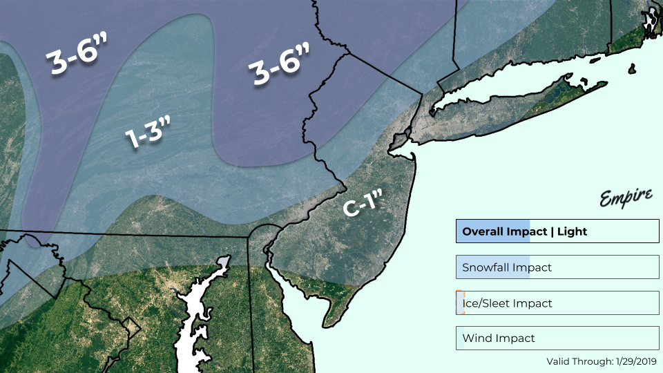
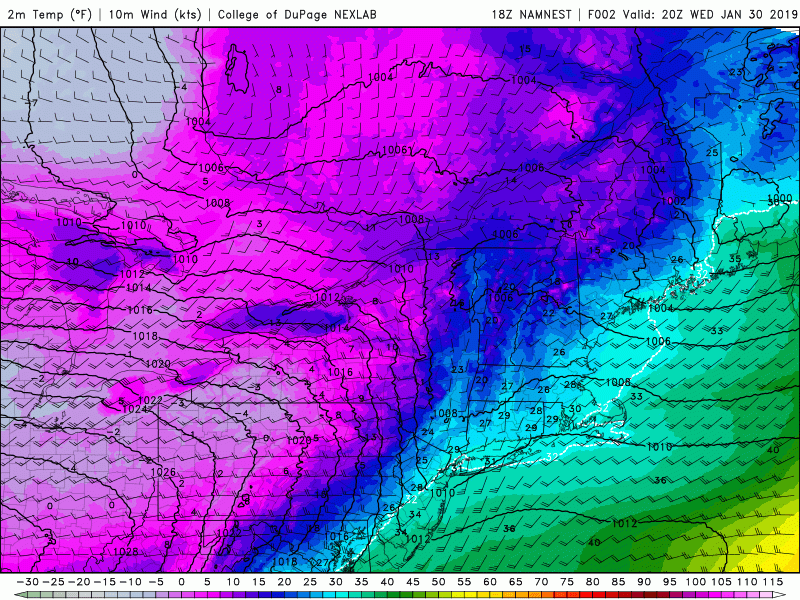
Our latest impact map for the light mix event tomorrow. The main impacts from this system will primarily be felt well off to the north and west of the city

Frigid Arctic Air Arrives Thursday

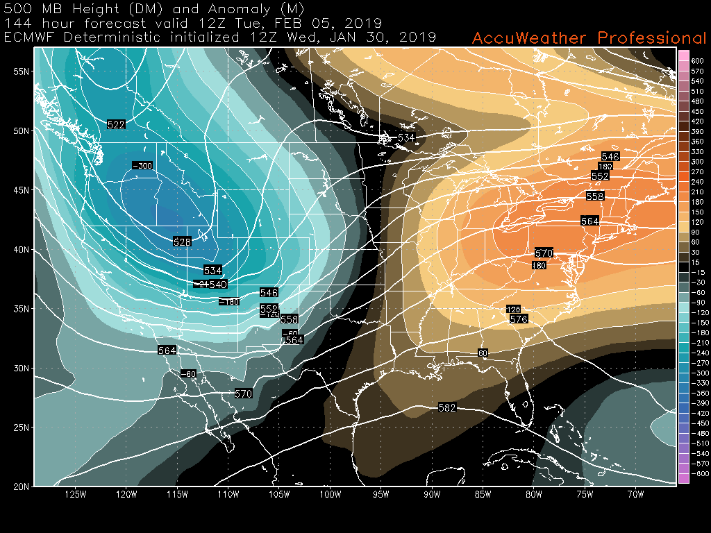
The long-awaited “polar vortex” will be located just to the north of the Great Lakes by Wednesday morning, with very deep westerly flow overspreading the Northeast. The cold front associated with the weak surface low to our north will be exiting off the coast Wednesday morning just in time for the AM commute, allowing for gradually clearing skies. While the airmass behind this first front will be quite cold, the main Arctic front will wait until the afternoon hours of Wednesday to work its way into the NYC area. Southerly flow at the surface will overspread the NYC area ahead of the main Arctic cold front, allowing for temperatures to rise into the lower to middle 20’s Wednesday afternoon.

The aforementioned deep westerly flow directly associated with the strong tropospheric vortex to our west will cause mid level temperatures to plummet over the Northeast before surface temperatures have a chance to respond. This will create impressive “lapse rates” (change in temperature with height) Wednesday afternoon over the majority of our area. Furthermore, some weak mid level energy will be edging into portions of the Mid-Atlantic and Northeast during Wednesday afternoon. This setup will create the potential for some snow squalls to develop and quickly move from west to east around 12pm -4pm on Wednesday. Some of these squalls could be quite heavy in nature, producing very low visibilities at times and potentially dropping a quick coating to an inch for some locations. The Arctic front will finally blast through the NYC area during the late afternoon and early evening  hours of Wednesday. Winds will quickly increase to around 20-30 mph, with gusts up to 40 mph as overnight low temperatures rapidly fall into the single digits across the entire forecast area–with temperatures likely falling below zero for elevated locations off to the north and west.

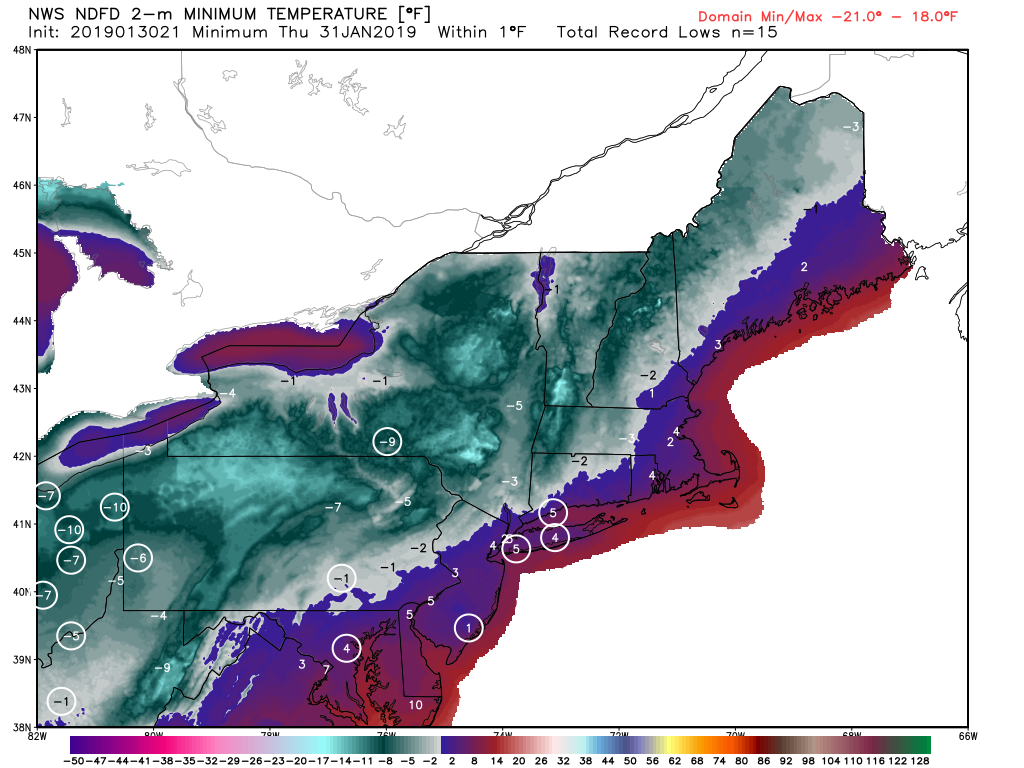
Thursday will be one of the coldest days of this winter season as highs struggle to make it out of the lower to middle teens for virtually the entire Northeast. Highs will be anywhere from 20-35 degrees below normal across the Northeast Thursday afternoon-which may wind up breaking a few records across the region. Wind chills will also be extremely cold, with readings likely anywhere from 10-20 degrees below zero by Thursday morning. Frigid and calm conditions will continue into the evening/overnight hours of Thursday, with lows in the single digits over the entire area.

Temperatures will moderate a bit on Friday, with highs likely getting back into the lower to middle 20’s, before a more significant warm up takes place later on this weekend.

2m Temp Anomaly

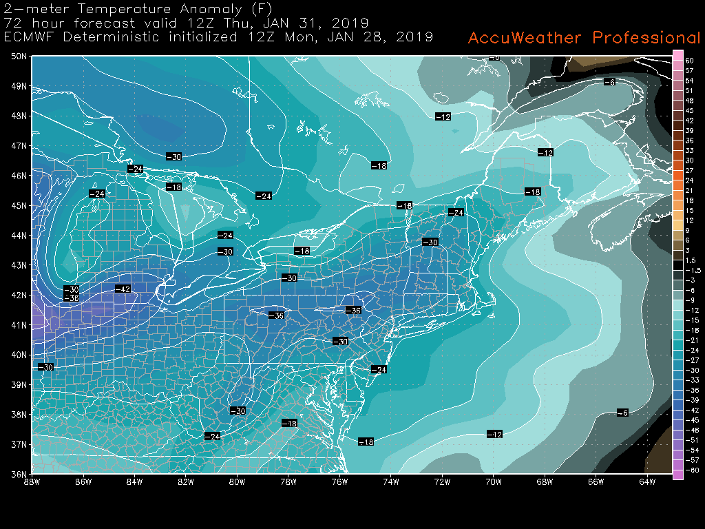
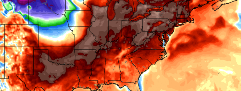
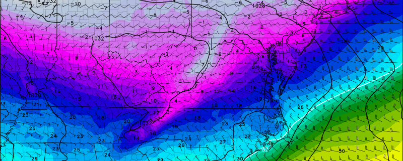
ECMWF model showing surface temperatures anywhere from 24-36 degrees below normal on Thursday morning (AccuWx)

We’ll have an update on this Arctic airmass as well as a look at this weekend’s weather on Wednesday!

Have a great night!

-Steve Copertino