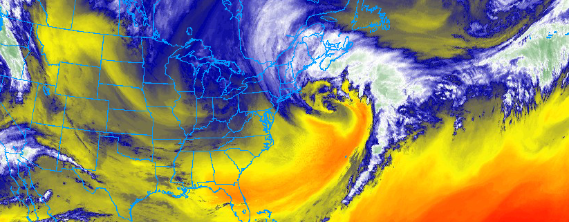
Three weeks removed from a large-scale pattern change which featured the development of a classic Greenland Block, we have experienced three Nor’Easters, all of which have been impactful in the Northeast states. As we move towards midweek, much of the Northeast states will finally catch a break. The departing Nor’Easter will leave blustery conditions with a few snow showers and squalls expected, but overall conditions will improve as high pressure builds in.
Temperatures will remain well below normal, and that will be the theme of the next several days – Cold. Much of this can be attributed to the re-development of another Greenland Block during the next few days, as forecast models suggest the pattern will begin to reload. Greenland Block’s are, in their nature, ridges of high pressure over Greenland and the higher latitudes of the Arctic that dislodge cold air further south into Canada and the Northeast States.
https://www.nymetroweather.com/wp-content/uploads/2018/03/Screen-Shot-2018-03-13-at-5.52.27-PM.png334823John Homenukhttps://www.nymetroweather.com/wp-content/uploads/2024/02/Empire-2000-x-300-px-2.pngJohn Homenuk2018-03-13 17:53:462018-05-01 12:45:14NYC Area Forecast: Improving conditions lead us to midweek
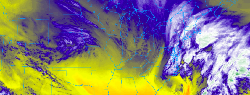
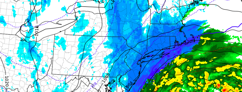
Another significant Nor’Easter is set to impact the Northeast states on Tuesday – this time with the worst of the storm passing well east of NYC and impacting Eastern New England.
The third Nor’Easter in as many weeks (well, technically just over two weeks) is set to impact the Northeast states on Tuesday, bringing widespread impacts from just east of New York City into Long Island and all of New England. This storm’s formation was well underway this morning and it is expected to continue to strengthen through Tuesday morning and afternoon across the Northeast States.
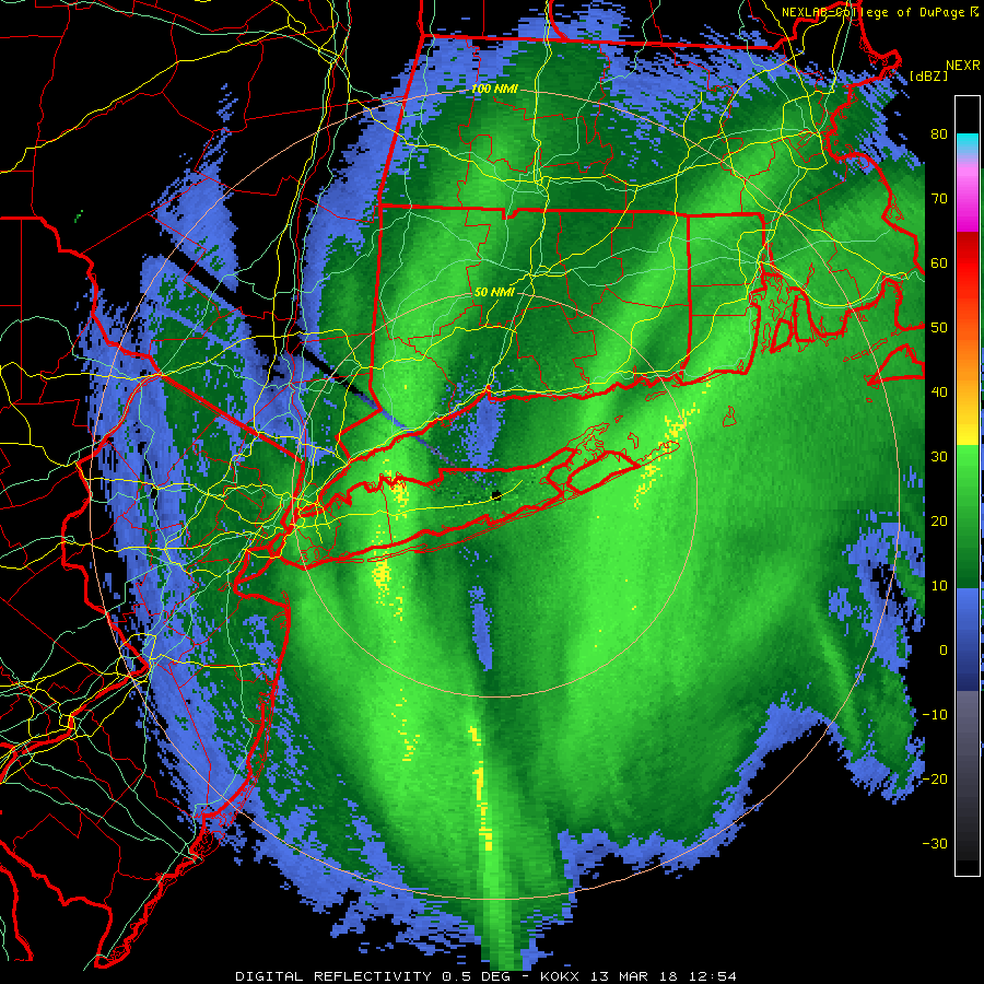
Heavy snowfall rates of 1″ to 2″ per hour and perhaps even higher with reduced visibilities may for hazardous driving over next few hours. Snowfall totals over parts of Long Island and CT have been 2″ to 5″. These totals will likely double later this morning, especially over Suffolk County and New London County in CT. Although roads may not receive as much accumulation with surface temperatures between 32 to 34 F.
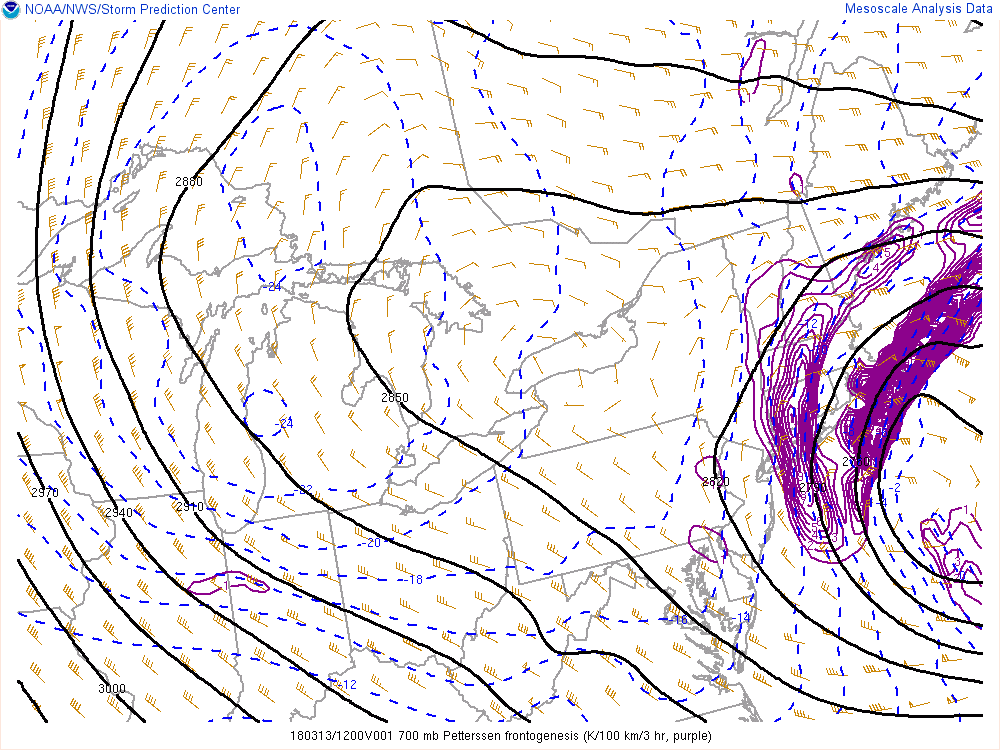
Current SPC mesoscale analysis , showing strong 700mb frontogenesis over Long Island and Connecticut.
Elsewhere, over most of New Jersey and the Lower Hudson Valley and Eastern PA snow appears to be winding down. A small moderate band has build back over NYC and extending into the ocean. This should shift east during the next hour. Snow will taper off to snow showers everywhere by around noon. Snowfall totals will likely wind up between 2″ to 5″. Although many paved surfaces, including roads, especially in NYC will likely receive less accumulation, with temperatures now in the mid 30s.
-Miguel Pierre
7:00am Tuesday Update:Snow is spreading throughout New Jersey and New York this morning, with light accumulations in many suburbs. Snow is much less likely to stick in New York City proper with warmer ground and pavement temperatures. This light snow will continue for the next few hours before beginning to pull back toward the east, with heavier bands developing towards Long Island and Connecticut.
The difference between this storm system and the past few will largely be the area it will impact. It otherwise parallels the other two storms very closely; it is powerful, rapidly intensifying, extremely dynamic, and will bring a myriad of impacts to the area it affects. The area most strongly affected with this one, however, will be Eastern New England and Long Island, where heavy snowfall and strong winds are likely.
https://www.nymetroweather.com/wp-content/uploads/2018/03/Screen-Shot-2018-03-12-at-8.47.29-PM.png386940John Homenukhttps://www.nymetroweather.com/wp-content/uploads/2024/02/Empire-2000-x-300-px-2.pngJohn Homenuk2018-03-12 20:48:032018-05-01 12:45:44Nor’Easter set to impact the area today, worst east of NYC
Good morning! Our latest video elaborates on the evolution of our snowstorm for tonight into Tuesday. It will become quite a powerful Nor’Easter and bring a blizzard for Southern New England, but most of the heavy snow will ultimately not affect our area. We explain why that is the case, but also why there is enough volatility to this setup such that small, and still possible short term changes with the evolution of the storm could have a vast impact on the track of the storm.
We also take a look at current observations to check how it compares to some of the models. We can automatically give more credence to a model that appears to be simulating the current atmosphere correctly, but any vastly snowier outlier that already has the pattern in the 5:00am – 8:00am timeframe wrong will only have that error compounded with time, and thus needs to be discarded. But again, given the volatility, there is still a chance that a model that initialized correctly can still output a snowier solution.
Regardless, however, the partial interaction between a polar shortwave and a potent southern shortwave will allow some light to moderate snow in our area, perhaps bringing quite the slick Tuesday AM commute.
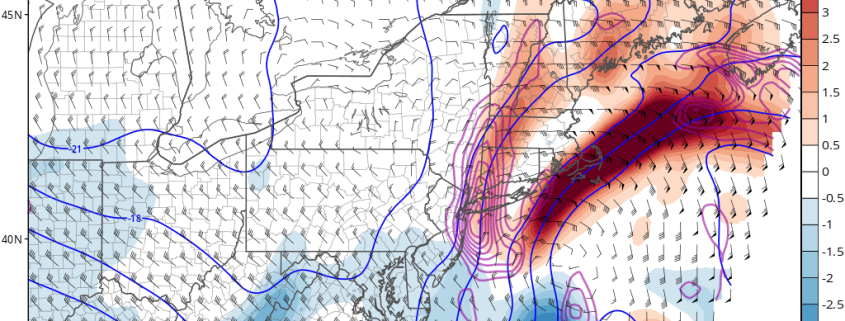
https://www.nymetroweather.com/wp-content/uploads/2018/03/nam3km_temp_adv_fgen_700_neus_31.png7721024Doug Simonianhttps://www.nymetroweather.com/wp-content/uploads/2024/02/Empire-2000-x-300-px-2.pngDoug Simonian2018-03-12 06:51:542018-05-01 12:46:17VIDEO Analysis: Light to Moderate Snow Likely, Some Changes Still Possible
Good morning, we hope you had a great weekend!You can listen to our audio weather briefing from Sunday evening above.
Sunday was the winner of the weekend weather, with limited clouds and plenty of sunshine underneath a calm and cold high pressure. Despite the cold air overhead, you probably noticed the warm sun – which is becoming increasingly apparent this time of year. We are quickly approaching Spring, after all. The overall weather pattern simply isn’t cooperating just yet.
After two huge Nor’Easters over the past two weeks, we’re expecting our third on Monday and Tuesday. Another powerful cyclone will develop off the coast (beautiful satellite imagery is coming your way!) and bring widespread impacts, this time focused on New England. New York City proper looks to escape the worst impacts of the storm system, as we have been detailing for several days now. But parts of Long Island, Connecticut and Southern New England are likely to experience impacts of more significance.
Hi friends! Our website uses cookies to provide an optimal browsing experience for you. New "Cookie Consent" laws mandate us to inform you of this. As long as you're cool with it, just hit OK. You'll only see this message once.
We may request cookies to be set on your device. We use cookies to let us know when you visit our websites, how you interact with us, to enrich your user experience, and to customize your relationship with our website.
Click on the different category headings to find out more. You can also change some of your preferences. Note that blocking some types of cookies may impact your experience on our websites and the services we are able to offer.
Essential Website Cookies
These cookies are strictly necessary to provide you with services available through our website and to use some of its features.
Because these cookies are strictly necessary to deliver the website, refusing them will have impact how our site functions. You always can block or delete cookies by changing your browser settings and force blocking all cookies on this website. But this will always prompt you to accept/refuse cookies when revisiting our site.
We fully respect if you want to refuse cookies but to avoid asking you again and again kindly allow us to store a cookie for that. You are free to opt out any time or opt in for other cookies to get a better experience. If you refuse cookies we will remove all set cookies in our domain.
We provide you with a list of stored cookies on your computer in our domain so you can check what we stored. Due to security reasons we are not able to show or modify cookies from other domains. You can check these in your browser security settings.
Other external services
We also use different external services like Google Webfonts, Google Maps, and external Video providers. Since these providers may collect personal data like your IP address we allow you to block them here. Please be aware that this might heavily reduce the functionality and appearance of our site. Changes will take effect once you reload the page.
-2")