Another beautiful weekend, slow warmth but no big heat next week

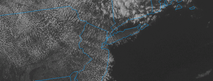
Another delightful weekend is on the way, as a ridge of high pressure has settled in behind a cold front. The ridging extends throughout much of the atmosphere, which is preventing clouds from forming — thus the crystal clear blue sky day we have had this afternoon.

place-holder

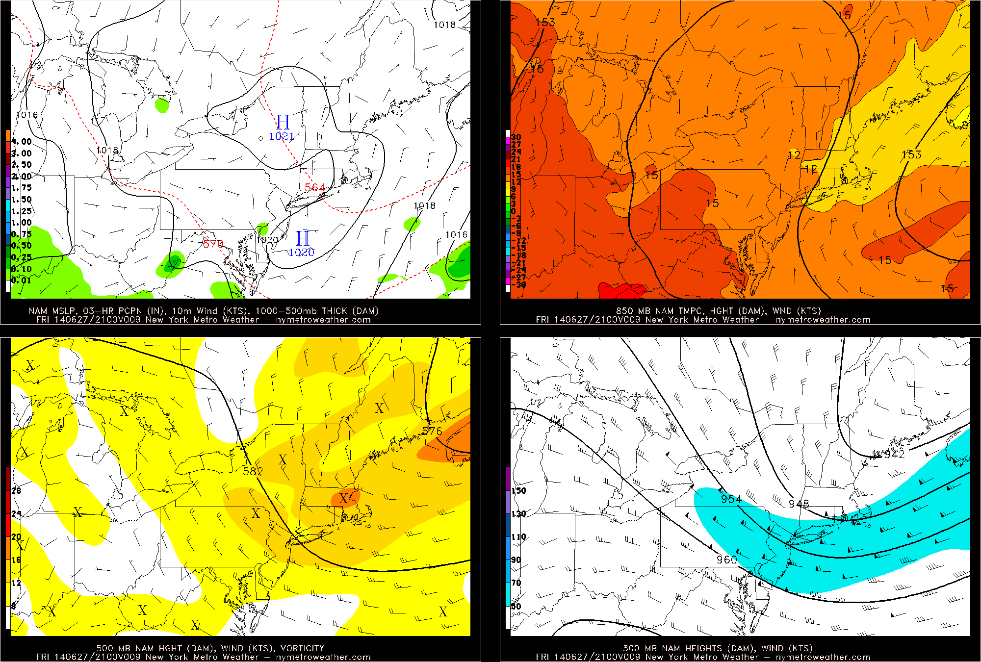
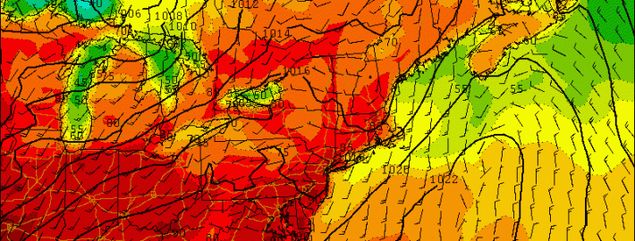
Today’s NAM valid for 5:00pm this afternoon shows an ideal combination of weather features throughout the entire atmosphere for sunny and tranquil conditions.

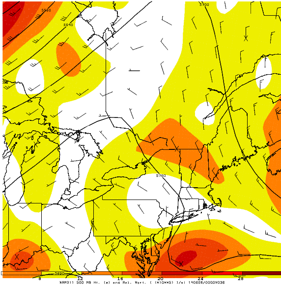
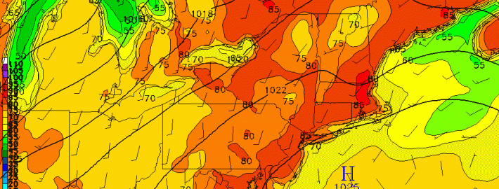
The above is a 4-panel chart from the NAM model valid for 5:00pm this afternoon. On the top left, we can see a well-defined area of surface high pressure — on the top right, we can see a nice ridge in our 850mb heights, as well as 850mb temperatures between 12 and 15C, which under sunny skies, yield high temperatures around 80 degrees. We also see that we are on the downstream side of the ridging at 500mb and 300mb, which further yields downward vertical motion associated with higher surface pressures — thus a lack of clouds. This general weather pattern will persist through the entire weekend, leading to sunny skies, low humidity, and temperatures in the low-to-mid 80s.

Read more

Heat builds, severe thunderstorm risk increases

As a mid level ridge builds throughout the eastern half of the nation today, temperatures in the mid and low levels of the atmosphere will increase. South of a warm front, which is organizing and becoming more well defined to our north, west-southwesterly winds will begin to usher in the warmer airmass. Mid level temperatures (at 850mb) will warm over 17 C, and with sunshine expected during the afternoon hours on Tuesday, temperatures will warm into the upper 80’s to lower 90’s. When coupled with increasing humidity, it will feel hot and quite muggy.

Back to our west-northwest, a mid level disturbance will be riding along the northern periphery of the building ridge axis. As it does so, it will help to trigger the development of thunderstorms — some of which could be strong to severe. These storms will initially form well to our north and west, but are expected to slide east-southeastward through the Northeast States as the disturbance shifts accordingly. Subsequently, the Storm Prediction Center has placed much of the area in a Slight Risk for severe thunderstorms.

Read more

Heat and humidity on the rise, severe thunderstorms possible Wednesday

As another beautiful weekend comes to a close, the weather will begin to change during the upcoming work-week. The airmass as a whole will become much warmer and more humid, which will lead to a true summer-like feel on Tuesday and Wednesday. Today will be a transition day.

One of the great indicators of the type of atmosphere we have is the amount of precipitable water in it. Precipitable water essentially tells us how much water would result at the surface if the entire atmosphere were to be squeezed out — like a wet towel. Thus, it is a good indicator of how much moisture is in the entire atmopshere, and not just at the surface. Large-scale changes in precipitable water is often a good indicator that the airmass is changing.

Over the past couple of weeks, we have been developing some of our own computer model forecast images. The main ones we will be using in this article overlay precipitable water, CAPE (Convective Available Potential Energy), CIN (Convective Inhibition), and 1000mb-500mb wind shear (essentially the wind shear [change in wind speed and direction] from the surface up to around half way up the atmosphere).

Today looks to be a transition day.

Notice the dry colors for precipitable water on Monday afternoon, still indicating a dry airmass. Image was produced by Doug Simonian using GEMPAK from the Rutgers synoptic server.

Notice the dry colors for precipitable water on Monday afternoon, still indicating a dry airmass. This image and all future images in this article were produced by Doug Simonian using GEMPAK from the Rutgers synoptic server.

The forecast for this afternoon shows precipitable water values still well under an inch — indicating a dry atmosphere. Thus, today for the most part should feel similar to how today felt, but perhaps a touch more humid. Skies will be sunny, but high clouds will be on the increase, and highs will be in the low 80s, with little wind.

Notice how the much more moist values are just off to our west.

Read more

Wonderful weekend, muggy with showers and thunderstorms early next week

The recent trend of an unsettled work-week, but great weekend will continue, as an area of high pressure has settled into the region, and the previous frontal boundary has finally cleared. This leads to northwest winds, which are much drier in nature, thus the lack of precipitation. However, the trough that caused yesterday’s rainfall is still not too far to our northeast. This leads to cold temperatures in the middle and upper parts of the atmosphere. Once the sun heats the ground, the warm ground combined with the colder temperatures above lead to an unstable atmosphere, causing lift for cumulus clouds. This is why the sun will be peaking in and out of clouds for the rest of this afternoon. The cumulus clouds are well-evidenced by the current satellite. The stronger ones with potential showers are staying to our northeast.

Regardless, the dry atmosphere and high pressures will preclude any precipitation from forming. As high pressure continues to build in and the air gets drier, the cumulus clouds will taper off during the evening. The leftover diminishing clouds combined with temperatures in the mid 70s at the shore should lead to a great evening to view the sunset. Be careful of rip currents, however.

Tonight and Saturday: The decreasing clouds combined with a dry atmosphere will lead to ideal radiational cooling conditions. Some of you may even want a light jacket or sweatshirt tonight, as low temperatures may fall into the low to mid 50s for much of the area, though slightly warmer in the city itself. For tomorrow, the ridge will build in more strongly, leading to fewer clouds and warmer temperatures than we had today. Temperatures should rise into the mid 80s with low humidity and plenty of sunshine, with light winds. At the shore, temperatures will initially climb around 80, but the light winds and warm temperatures will not be able to stop a sea breeze, so winds may get gusty at times, but otherwise a beautiful beach day. Potentially more importantly, the weather will be great as California Chrome goes for his Triple Crown!

Today's 12z NAM at 500mb valid for tomorrow evening shows a large ridge building into the region. This will lead to a beautiful Saturday and Sunday. Image produced via GEMPAK computer program.

Today’s 12z NAM at 500mb valid for tomorrow evening shows a large ridge building into the region. This will lead to a beautiful Saturday and Sunday. Image produced via GEMPAK computer program.

Read more