Light snow tapers off this morning…more light snow possible Saturday

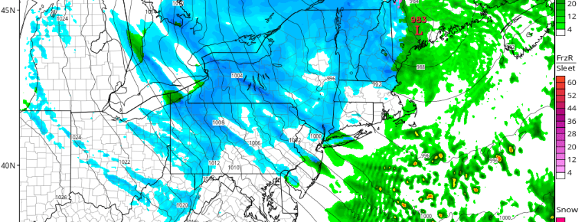
Snow has begun tapering off and ending southwest to northeast across all zones early this morning. This occurs as low pressure tracks east-northeast off the North Carolina coast and more lift with an associated upper-level jet streak start to move the northeast of the region. Most snowfall reports so far have been between 1” – 3″, as expected.  Some additional light accumulation is possible over the next few hours over Eastern parts of Long Island and Connecticut that could bring snowfall totals to near 4”. Otherwise, take more precaution driving out roadways, as some slick spots will likely remain for another into the mid-morning hours.

Read more

Multiple Wave-Breaking Events Support an early January Snowstorm

While the coast is experiencing yet another rain event to end 2016, there are many changes currently ongoing to the pattern that could open the door for a widespread snow event in the beginning of 2017. How long the pattern change lasts for is a different discussion and will be talked about in our long range update tomorrow, but for now we will be focusing on the changes over the next week.

We first place our eyes on the Pacific. A couple of days ago, there was a strong Pacific Jet and the flow was somewhat zonal in the Pacific, and to some extent that is still currently true. But looking closely, there was an active wave train of ridges and troughs, despite the relatively flat flow. It wasn’t just one straight buzz-saw — there were ripples to this pattern that could easily lead to more amplification in a short period of time. While this isn’t the sole cause of the eventual wave-break, we have a cut-off low in the Southwest that retrogrades, and that began to slow the pattern down upstream in the Pacific. And when there are already ridges and troughs in-place, sometimes it just takes one slow-down to truly shake things up.

Read more

Weekly Overview: Transitional weather, interior winter storm possible late week

It was dreary today with lots of cloud cover and spotty light rain and drizzle in some areas. High pressure is now moving out into the Atlantic, while low pressure from the Midwest tracks into Southeast Canada.  This will allow for a warm front to lift further northward through the Northeast states this evening, with winds turning more southwest overnight. Cloud cover will remain in place most of the night with some light rain or drizzle still possible.

Temperatures will gradually rise through the 40s into the 50s later tonight and Tuesday, especially closer to the coast.  These temperatures will be mild for late December. A cold front moves through the Northeast states with more showers possible Tuesday morning and early afternoon.  A mid-level shortwave and upper-level jet streak drifting through may aid in more lift, but moisture appears somewhat limited with this front based on this evenings guidance. So heavy rain is not anticipated.

Read more

Premium: Snow Squalls Possible on Sunday

Although we have generally been basked in a sea of warmth, we are getting to the time of year where snow becomes a more realistic possibility. A large storm system traversed the central part of the US, bringing blizzard conditions to the upper Plains and upper Midwest. While the pattern across most of North America has been pretty warm thanks to a raging Pacific Jet, this storm is powerful enough to tap into some cold air up north — while that air is not as cold as it “should” be this time of year, that air is still cold enough that if tapped into, could yield snow, if there is precipitation, of course.

Ahead of this storm, more warmth has moved into the Northeast, with high temperatures in the upper 60s today. A little bit more in the way of onshore flow is expected on Saturday, which may keep temperatures a tad cooler, but they still will be overall quite warm for this time of year — into the low to mid 60s. But part of this warmth stems from being ahead of a cold front, and once this cold front crosses, cold air advection will be taking place, but it will also be aided by a deepening secondary low pressure system, funneling in cold air from Canada and tapping into the aforementioned cold air.

Read more