-2")
Unsettled and Cooler Conditions Dive In, Irma Becomes a Category 4 Hurricane
Good Evening and Happy Labor Day!
Today was a rather big improvement from the dreary and cool conditions that we experienced this weekend over much of the northeast, with mainly sunny skies and light winds throughout the day. A weak area of mid level ridging over the east provided adequate southwesterly flow, which ushered in highs ranging from the upper 70’s to middle 80’s across the area. This pleasant weather should last into the evening as a weak surface high pressure system associated with the mid level ridge begins to move off the Atlantic coast and into the West Atlantic. This will allow for winds from the south to persist into the evening, but conditions will be supportive for some radiational cooling to take place. Expect temperatures to drop into the lower 60’s to middle 50’s across the area, with locations well removed from the coast a good 5 degrees cooler.
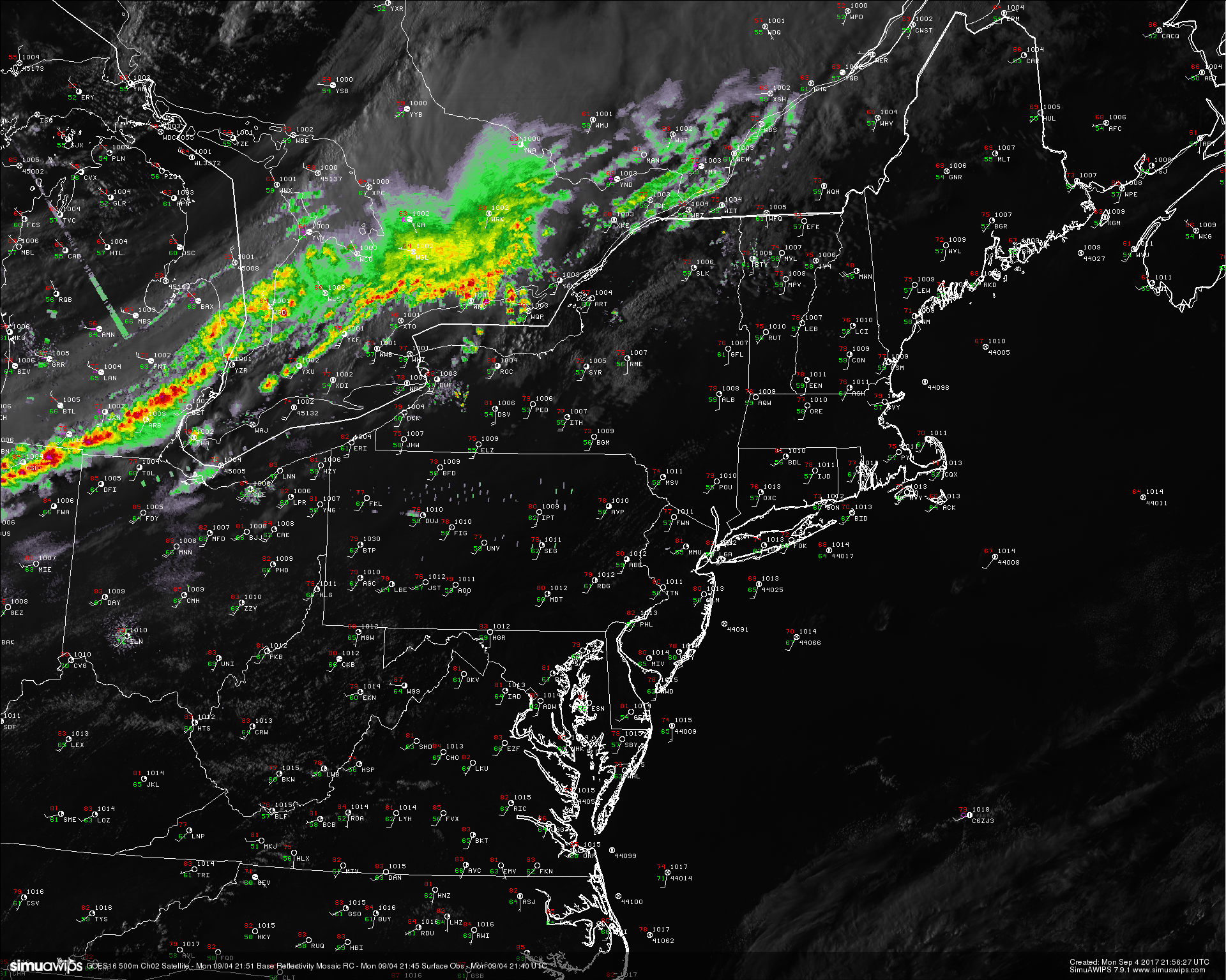
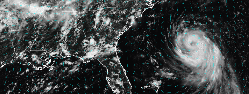
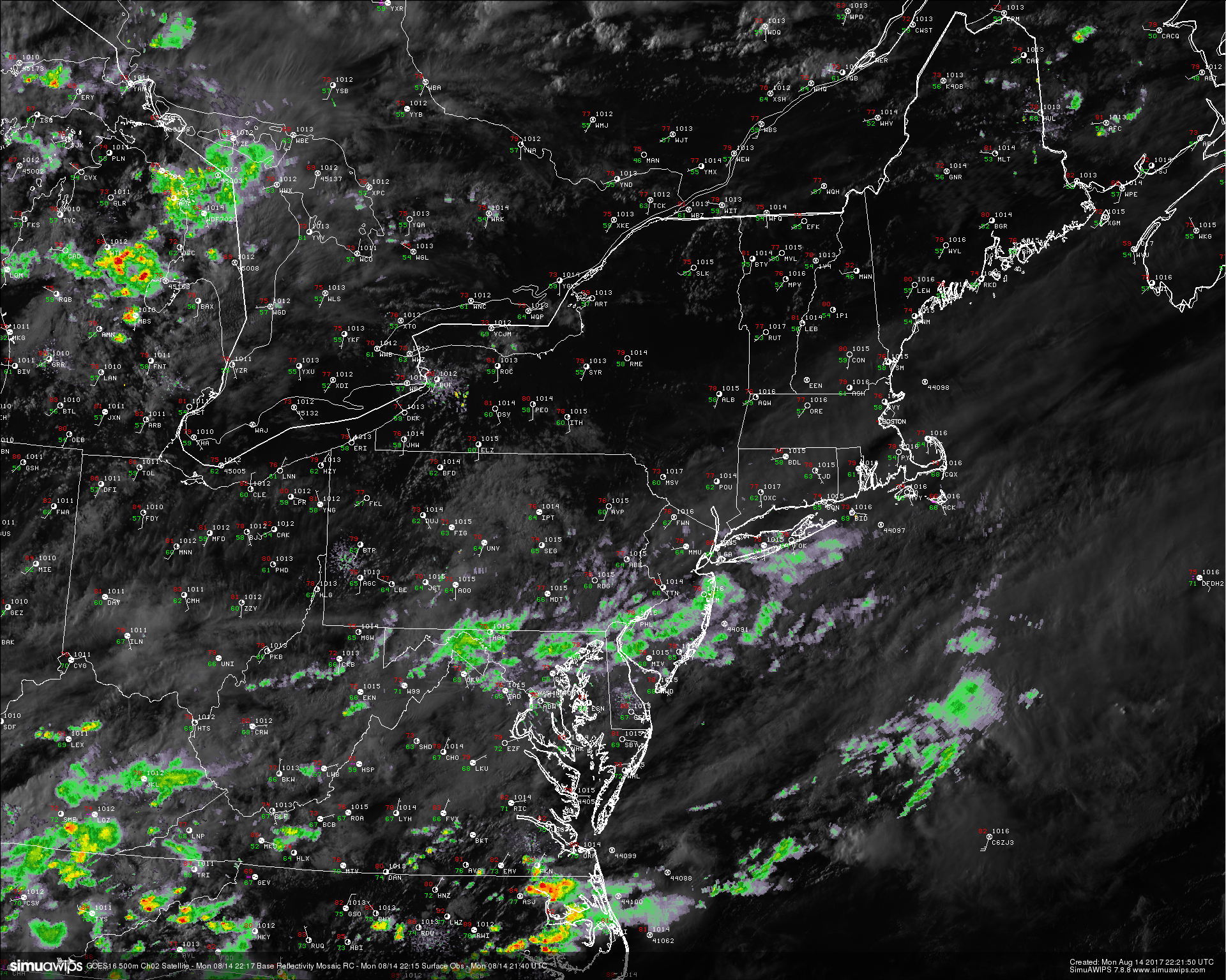
This evenings latest high resolution GOES-16 visible satellite imagery, regional radar mosaic, and surface observations showing a rather tranquil and pleasant Labor Day (Courtney of Simuawips)
Tuesday into Wednesday
Tomorrow should start off rather calm for much of the area, with partly cloudy conditions likely taking over by mid morning. A large upper level trough will be moving down from Canada and into the northern portions of the Northeast. This cold front will likely spark some showers and thunderstorms over portions of the Northeast during the afternoon hours, however this feature will likely take a while to reach the area. Otherwise, more strong south-westerly flow just ahead of the impressive trough will overspread the area. This will once again lead to warm mid level temperatures, which should be able to support highs into the middle to upper 80’s by late tomorrow afternoon. As with many high mid level temperatures/questionable cloud cover days, the areas that see more sunshine during peak heating will likely wind up a few degrees warmer than the areas that stay mostly cloudy. Precipitable water values and dewpoints will also begin to steadily increase during the day, and this will make for a more “muggy” feel to the day tomorrow with heat indices possibly reaching into the lower 90’s.
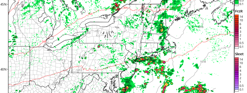
As we move later into the day, the cold front will begin to move to the east with time-likely setting off numerous showers and thunderstorms over Pennsylvania and New York. PWATS will be quite high just ahead of the front, and a very impressive upper level jetstreak will promote expansive upper level divergence, which will work to enhance convergence at the surface. Additionally, the upper level trough moving in will be quite large and powerful for this time of year, and will have some decent wind shear associated with it. When all these ingredients come together later in the day on Tuesday, very heavy rainfall will be possible with any showers or thunderstorms that develop west of the immediate NYC metro area. If a less-cloudy solution works out tomorrow, we could see instability rise over the area, which would be supportive for more strong-severe thunderstorms with strong winds, frequent lightning, small hail, and torrential downpours all possible.
These showers and thunderstorms should gradually work their way towards the NYC metro area by the mid to late evening hours tomorrow. The activity will likely be on the downswing due to a loss of daytime, so they will likely be below severe limits, even though gusty winds, frequent lightning and heavy rains will still be possible. There is a minor concern for flash flooding as the north to south orientation of the trough will allow for the showers to train over the same locations as the night goes on. The one positive thing about this scenario will be that the increased shear values will allow for the showers and storms to move rather quickly. This should limit the overall flood threat to roads and poor drainage areas.
By Wednesday morning, the cold front should be along the Mid Atlantic coast, but beginning to slow down significantly as it starts to bump into the west Atlantic ridge. The overall upper level trough will also begin to nudge up against the ridge and this should cause the associated upper level jet to expand and intensify as well. This will set the stage for a much cooler and unsettled day across the area as a Canadian airmass overspreads the area, and the lift from the impressive upper level jet provides support for showers and isolated thunderstorm development. Gusty winds will be possible with any of the stronger showers and thunderstorms, as they may be able to mix down stronger winds from high up in the atmosphere. Overall, expect temperatures to be limited to the middle 60’s across the area, which is a good deal below normal for this time of year.
There will likely be some residual rain on Thursday, with the core of the trough passing nearby. We will have more on this and this weekends conditions on Wednesday!
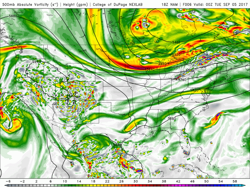
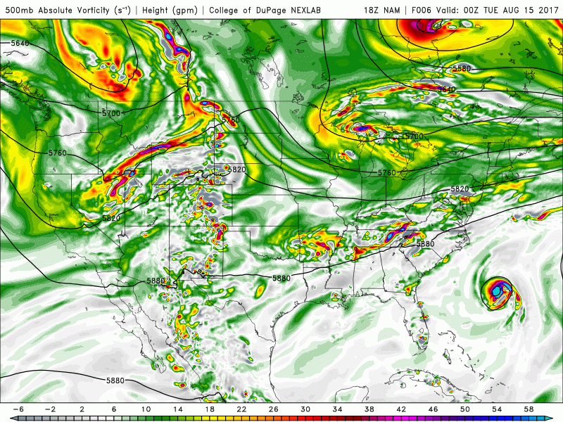
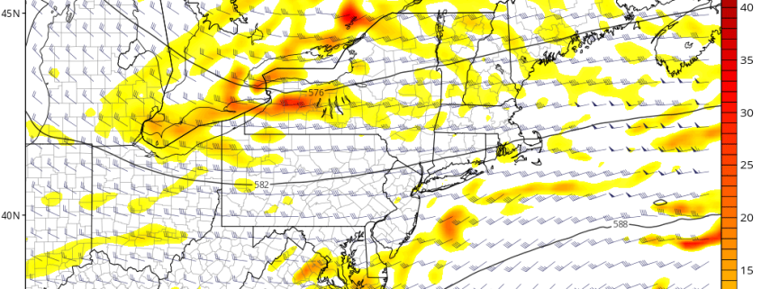
This afternoons NAM model showing the expansive full-latitude trough moving in and over much of the East.
Hurricane Irma Update
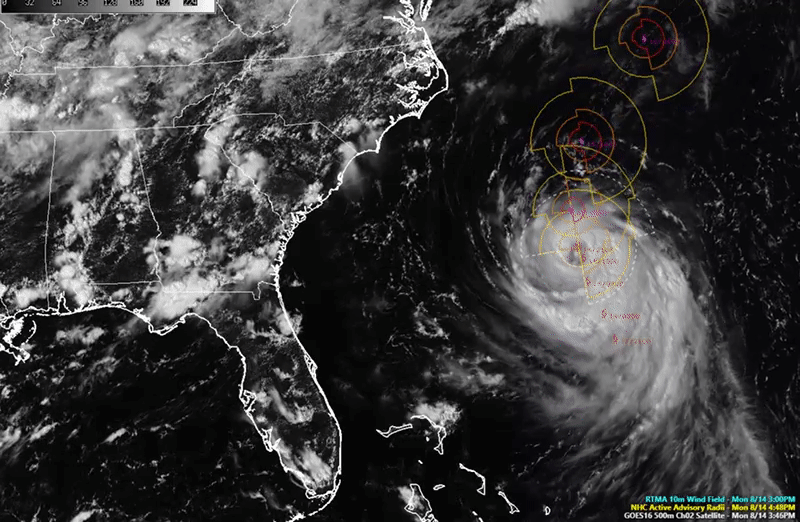
Hurricane Irma has intensified this afternoon after a Hurricane Hunter flight investigating the storm found winds up to Category 4 strength (130mph). The storm appears quite healthy on this afternoon/evenings satellite imagery , with very deep convection firing within the eyewall of the storm and upper level outflow expanding outward from the hurricane. The presence of upper level cirrus clouds has even increased in the northern half of the system, which has been lacking over the past two days due to a cutoff low pressure system imposing some northerly winds onto the system. Regardless, the system appears to be in a conducive environment for further strengthening over the next few days , characterized by low shear, very warm sea surface temperatures, and little to no dry air in the vicinity.
Irma will be moving towards the northern Leeward islands, with tropical storm conditions possibly affecting the area as early as tomorrow night. Irma will likely be a strengthening Category 4 hurricane by that time, and conditions are likely to rapidly deteriorate as it moves closer. The models have converged on the idea that the center of Irma will be over the US Virgin Islands during the day on Wednesday, and will likely bring extremely strong sustained winds, torrential downpours, life-threatening mud slides, as well as very dangerous waves/surge. With 36 hours left until direct impacts are felt, those in this area should rush preparations to completion as soon as possible! A Hurricane Warning has been issued for most of the northern islands, with a Hurricane Watch in effect for Puerto Rico.
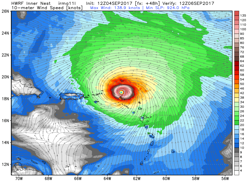
12z HWRF showing a very dangerous Hurricane Irma over the northern Leeward Islands (Valid 8am Wednesday)
Irma will likely move to the north of Puerto Rico late Wednesday, likely bringing tropical storm, to even hurricane conditions to the island. The hurricane will likely remain an extremely dangerous storm through this time, much of the same hazards-if not all apply. Irma should begin to move away by early Thursday morning and will likely continue heading west-northwest, just north of Hispaniola. This is around the point that some models begin to diverge on the exact track of Irma, with some keeping the storm moving towards the west and into the southern Bahamas, and others showing a stronger mid level ridge over the system attempting turn the hurricane a little south of due west and into Cuba. This will have to be monitored over the next few days, due to the fact that Irma would likely weaken a good deal if it were to interact with the mountains of eastern Cuba (which would have some impact on the eventual track). Interestingly enough, the later part of the forecast seems to be much clearer than it originally was, with multiple models and their ensembles showing Irma lifting north once its near the Cuban coast by this weekend. The main question will be just how far west does the storm get before its begins to move north? With near-continuous observation by NOAA and USAF planes, special soundings, and the activation of Critical Weather Days, we will be getting a massive amount of data ingested into the models that should help with the forecast of the next week or so.
Regardless, it can be said that there is an increasing hurricane threat for portions of south Florida, and residents in that area should closely monitor the progress of Irma over the next few days and begin to review their hurricane plans.
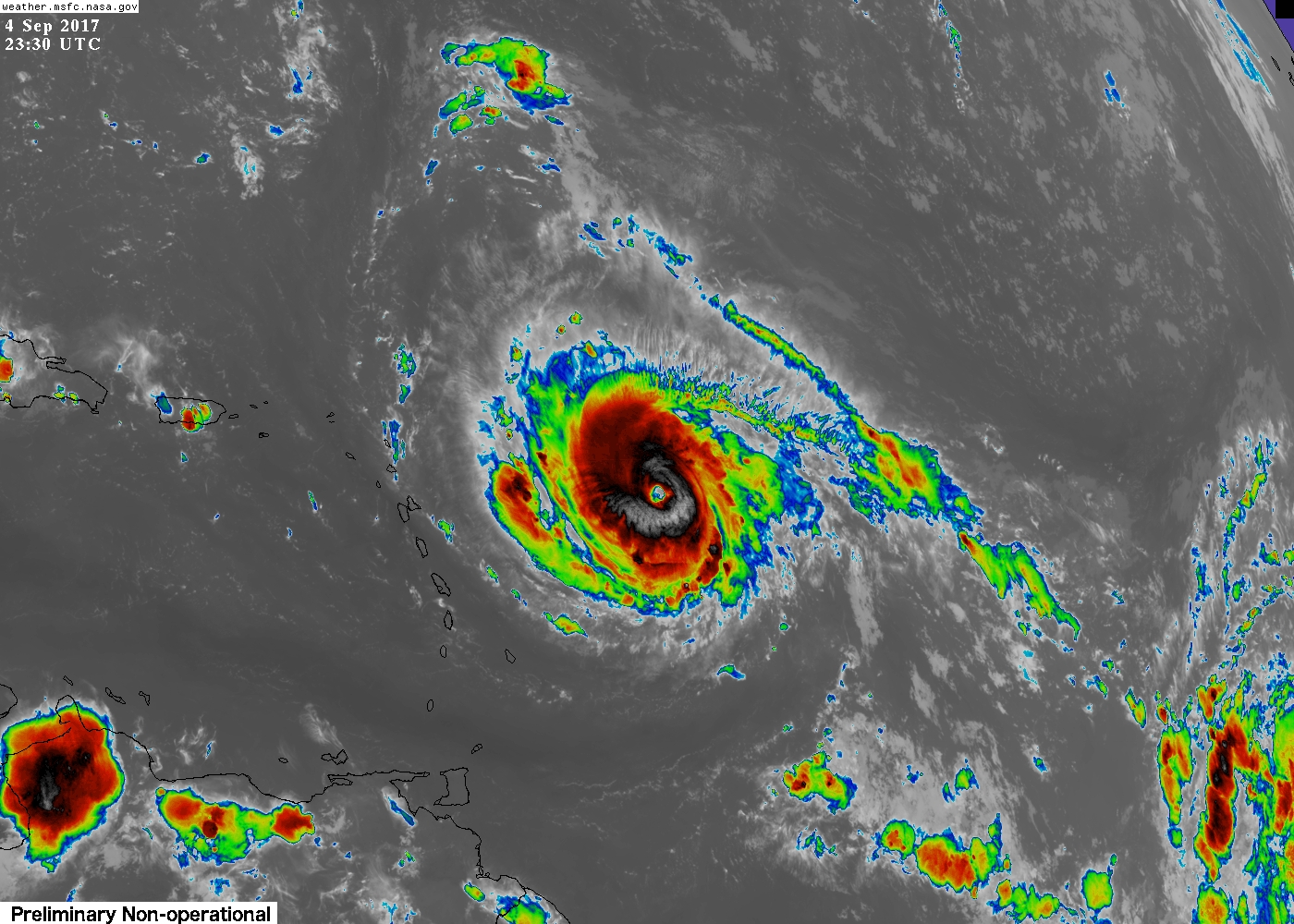
Category 4 Hurricane Irma over the Central Atlantic this evening as seen by GOES 16.
We will have more on Hurricane Irma on Wednesday!
For more information and posts like this one, make sure you sign up for Premium Forecasts — where multiple detailed articles, videos, and interactives are posted each day. Also, come interact with our staff and many other weather enthusiasts at 33andrain.com!
Have a great evening!
Steve Copertino