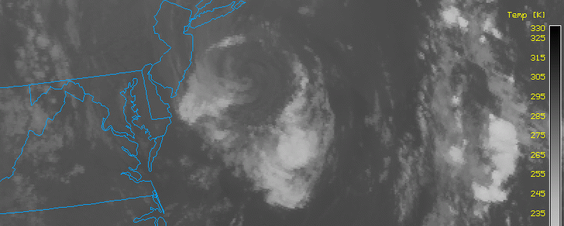
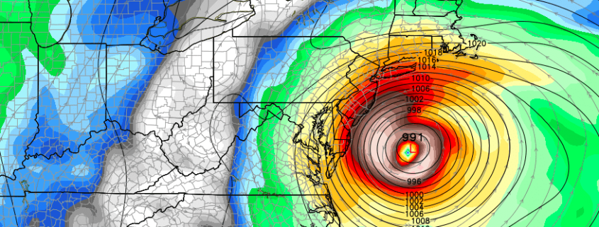
ENSO state in limbo as La Nina struggles

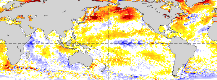
Much fuss has been made over the past several months in regards to the development of La Nina this year, coming on the heels of one of the strongest El Nino’s on record. There is a propensity for these things to occur, after all, and a significant cooling of Nino-region pacific temperatures led many to believe that a La Nina was not only on its way — but could be moderate or strong by the time cold season arrived in the Northern Hemisphere. Those ideas will not come to fruition.

The lack of La Nina development has, instead, been notable — with a significant lack of depth to any cooler sea surface temperature anomalies. Trade winds aren’t cooperating (we’ll get into that more later) and tropical forcing seems to favor this pattern continuing through the next few months. It appears likely, now, that La Nina will never truly get off the ground. Forecast models have responded, with monthly and seasonal data now pointing to a Neutral (La Nada) pattern through at least the first half of North America’s calendar Winter.

Read more

Wednesday Overview: Hermine still hanging around

You may have noticed some periods of squally, windy showers last night. Yes, that was actually from Hermine (or the remnants of it, anyway) — the system that we all just want to go away keeps finding a way to hang around. A blocking pattern captured the storm and allowed it to come back towards the area, fortunately  in a much-weakened state. But the weakening and transition to extra tropical in nature allowed some rain bands to expand away from the center of the storm, and back in to our area from the east.

The same general theme will continue on Wednesday, though with the storm continuing to weaken, the rain bands will be lessening in coverage. Some day-time heating may still try to enhance a few rain bands, but they will continue to be isolated to scattered in coverage and there may not be much at all west of I-95. We may see breaks of sun again — particularly for inland areas — as a large ridge builds into the area. This large ridge would be giving our area a heatwave had it not been for Hermine.

Read more

Heat returns to East, but active pattern awaits

The remnants of Hermine are still hanging around, off the coast of New Jersey and south of Long Island this afternoon. The system, in fact, has drifted farther south today than it has been all week — much to the ire of meteorologists and forecasters up and down the East Coast. Nevertheless, the storm will begin to have a lessening impact on our areas weather as the days of this week go on. The system is vertically stacked, at all levels of the atmosphere, meaning it’s cut off from moisture and lift sources.

Accordingly, the storm will fade out slowly over the next 24 to 48 hours, with only momentum carrying its circulation. As it does so, a large mid level ridge will build across the East Coast and Western Atlantic, as we have seen several times already this summer. This pattern looks to remain in place through the weekend, when temperatures will again approach the 90’s in many areas.

Read more

TS Hermine expected to impact NJ, NY Shores

Tropical Storm Hermine, is reemerging over the open waters off the Mid Atlantic coast today. The storm is expected to re-strengthen before turning more north and west, closer to the coasts of New Jersey and New York. A prolonged period of onshore winds and heavy rain is expected resulting in the potential for coastal flooding, beach erosion, and localized damage from wind.

Read more