PM Zone 4/5 (Southeast NJ) Update: Light snow tonight

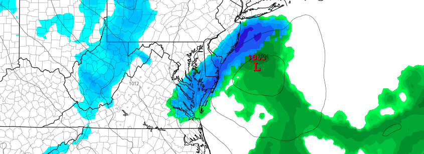
A weak low pressure system is developing this evening across the Mid Atlantic states, and will continue to move east/northeastwards to a  position off the New Jersey coast from later tonight into Sunday Morning. The low pressure area is associated with a deep, but progressive mid and upper level trough which is moving through the Northeast states as we speak. This trough is of polar origin, emanating from Canada.

The “clipper” system will develop through the evening, as lift in the atmosphere strengthens and expands. Additional moisture will also be drawn into the system as the low pressure center develops tonight. The two will coincide over Southeast parts of New Jersey from late Sunday Night into Monday morning.

Read more

1/29 AM Zone 4/5 (Coastal NJ): Clipper snows scrape the shore

A weak low pressure system, developing as a result of mid and upper level energy int he atmosphere surging southeastward from Canada, will develop off the coast of New Jersey on Monday morning. Forecast models have struggled with the exact track, intensity and location of the low pressure as it develops, leading to considerable forecast uncertainty over the next 12 to 24 hours. However, better agreement recently has increased confidence in impacts.

The low pressure system is developing from what is called a “clipper” system, or a piece of fast moving energy that drives southeastwards from Canada and then quickly moves out to sea or back northwards towards its origin. These storms can sometimes develop more rapidly and deepen if the energy is slower or more intense — but that is not the case here. However, a low pressure system will still develop offshore, and the juxtaposition of moisture and lift in the atmosphere will lead to the potential for bands of snow in the region on Monday morning.

Read more

1/27 PM Zone Update: Gusty, return to seasonable conditions this weekend

Today has been yet another cooler departure from the previous few days as much of the region is currently experiencing mostly cloudy conditions with some disorganized snow showers moving through the eastern areas of Pennsylvania and southern New York. These disorganized squalls have made some progress into central and southern New Jersey, but ultimately will have a limited impacts for the New York metro this afternoon and evening. Downslope flow and drier air work to keep these squalls on the lighter side and confined mainly to the north and western regions. However it is important to note that some of these bands could work their way down later this afternoon and produce reduced visibility as well as slippery roads for some folks in the area, so it is important to remain alert during the afternoon commute.

Otherwise, the main focus for the rest of today will be the gusty winds of around 20-30 mph affecting most of our area which can be attributed to a large low pressure system over eastern Canada. The locally higher areas of winds can be seen in the latest visible satellite imagery as ripples in the overall cloud pattern. As temperatures once again drop down this afternoon to the upper 30’s, we should begin to see the winds diminish and gradually die off once we head into the evening hours. Any remaining squalls and the mostly cloudy conditions should also depart this evening as temperatures fall into the middle to low 30’s for most of the area, with upper 20’s possible in the outlying regions.

Read more

1/27/17 AM All Zones: More Seasonably Cold Weather Returns

A mixture of clouds and sunshine is expected to dominate the weather today, as some instability and moisture will be around to keep some cloud cover over the region. But it will be mainly dry, with westerly downsloping winds. Temperatures will likely hold steady or slowly rise into the lower to middle 40s for most of the region, as another cold front moves through this afternoon. Winds could be gusty again behind this front, but they shouldn’t be quite as high as yesterday.

Read more