Dreary and complex weekend ahead

Good evening!

After the very light rain/snow mix yesterday, we’re now firmly entrenched within a much more mild and moist airmass thanks to the large upper-level system over the Southeastern US that we have been talking about since last week. This system has been quite challenging to nail down over the past few days, as key features that will determine the overall impacts from this system are constantly changing.

So what exactly has changed?

Well, the first major change that we’ve seen is that the system as a whole is quite a bit more disorganized than what the models originally projected, and this has led to the precipitation over the Southeast to also become quite disorganized and lackluster in nature. Another major change that we’ve seen is that a shortwave trough currently over eastern Canada has trended stronger and further south over the past couple of days, which is keeping the overall storm much further south than previously expected. Now if this sounds familiar to you, this is generally the same thing that happened with last weekends snowstorm that stayed well to the south of the Northeast but still managed to significantly impact portions of the Mid-Atlantic and Southeastern states.

With these two significant changes in mind, this means that the strong low-level jet that was supposed to overspread the Northeast will now be less impressive and much more suppressed to our south this evening and throughout the day on Saturday.

With the main mechanism for heavy rain potential now located our south, this evening and the majority of Saturday should really only be capable of light to locally moderate rain showers for much of the New York Metro area, with more steady rain likely over southern portions of New Jersey. Regardless, with warm air advection from the south increasing overnight and cloudy conditions remaining in place during the entire day on Saturday, we should see highs in the middle to upper 40’s over the entire area, with lower 50’s possible closer to the coast, making for quite the dreary day.

These temperatures will be running anywhere from 5-10 degrees above-average for this time of year, which is quite the change considering we were 10-15 degrees below-average earlier this week.

Dreary conditions likely this

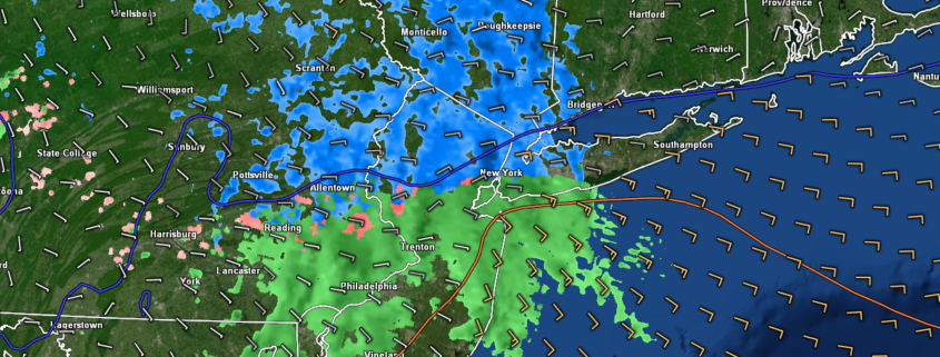
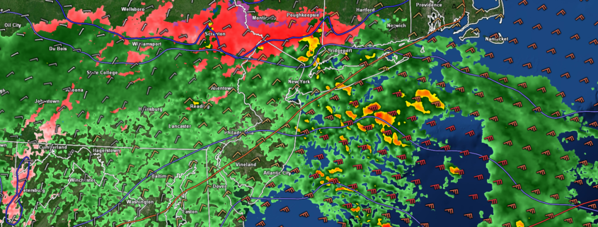
This afternoons high resolution NAM model showing the vast majority of the heavy rain staying to the south of the NYC area Fri/Sat

Unsettled conditions remain through Sunday night

As we head into the evening and overnight hours on Saturday, we should begin to see the upper-level low slowly begin to move into portions of the southern Mid-Atlantic states. As this systems pushes to our south late Saturday night and during the early morning hours of Sunday, the positioning of the upper-level system will allow for stronger areas of lift to develop from north to south, which should finally result in a batch of moderate to heavy rainfall pushing through the Mid-Atlantic and Northeastern states.

The complex part of this forecast really begins on Sunday afternoon when another shortwave trough will be quickly moving over southern Canada. Recent model trends have shown that this Canadian shortwave trough will have the potential to interact with the upper level low located to our south, which could help to spawn an area of low pressure off the New Jersey coast. While southerly flow and very marginal surface temperatures should keep precipitation limited to a dreary and cool rain throughout our area, we could see some colder temperatures begin to bleed in over the Northeast later Sunday afternoon. This will have some very important implications for locations well to the north and west of the New York city area as we head into the evening hours on Sunday when the surface low pressure system begins to strengthen off the New Jersey coast. With the colder air bleeding in from the north and the upper-level low to the south of Long Island providing sufficient lift for continued precipitation over PA/NY/NJ, there is the possibility that we could see rain gradually change to a wet snow/rain mix for locations over NE PA, SNY, and elevated portions of NW NJ. Again, temperature profiles are very mild and the best chance for a light mix of precipitation will come from “dynamic cooling” within heavier areas of precip to the NW of the city.

NYC Weekly Planner

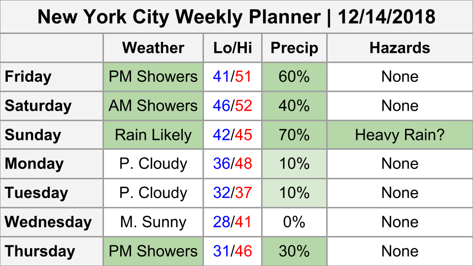
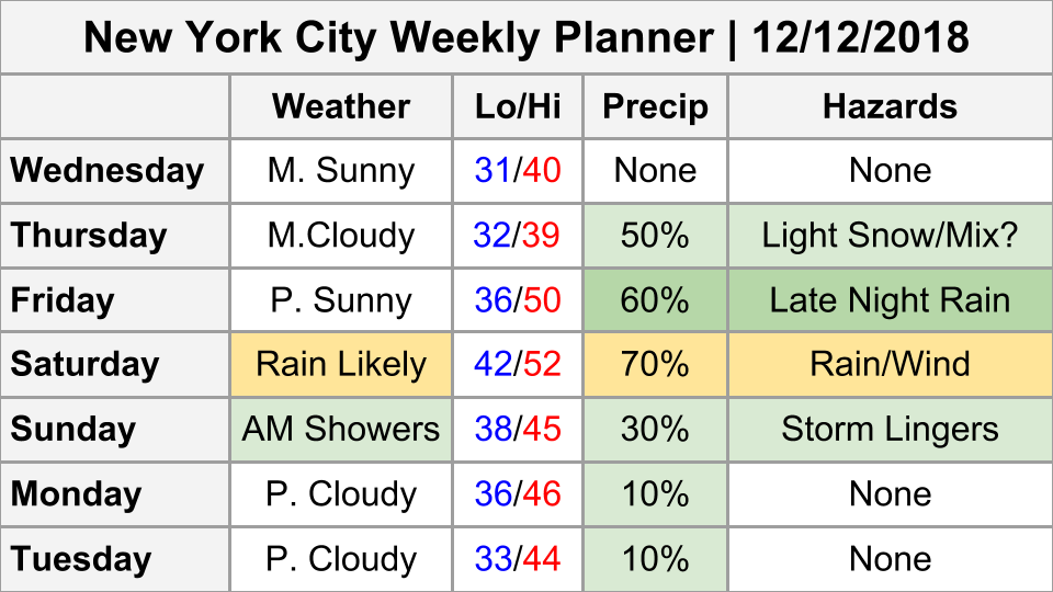
~Updated NYC Weekly Planner ~

Clear and cooler start to the work week 

As the shortwave trough moving through Canada gradually digs into the Northeast overnight on Sunday and into Monday morning, we should see the mild and dreary conditions gradually fade from northwest to southeast. A much cooler mid-level airmass will be moving into the area during the afternoon hours on Monday, which should also eliminate most of the residual clouds from this weekends storm system in addition to bringing high temps across the area back into the middle to lower 40’s. Relatively clear and calm conditions should persists through the middle of the week as an upper-level ridge and associated area of high pressure gradually builds in over the East. Highs will likely be limited to the upper 30’s to middle 40’s Tuesday to Thursday before our next potential storm system begins to build to our west. Unfortunately, it appears that we could be looking at yet another dreary weekend next weekend over much of the East as an area of low pressure develops well to our west, dragging mild/moist conditions  along the coast.

ECMWF 700mb RH and Winds

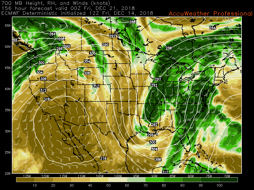
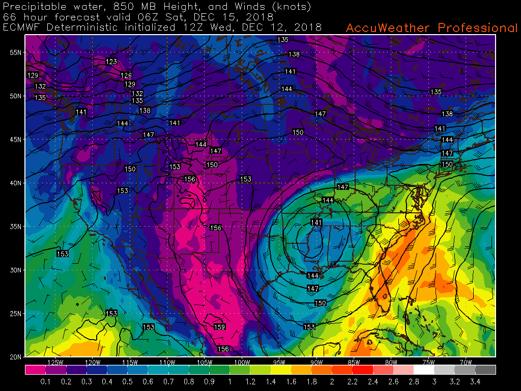
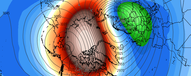
This afternoons ECMWF model showing much of the same late next week as another area of low pressure brings the potential for rain in the East

We’ll have updates on Sunday’s  wintry mix potential likely during the day tomorrow, so stay tuned for updates!

Have a great weekend! 

Steven Copertino

NYC Area Forecast: Weekend rain looks likely

Weekend Forecast Rating: Rain is increasingly likely this weekend, both on Saturday and Sunday, with dreary and damp conditions expected. 2/10

Light snow fell throughout the area today, and most of it has ended this afternoon. Some areas of light snow may continue through the evening hours residual moisture and lift in the atmosphere meander over the area. Near the coast, this will fall mostly as a mix of rain and snow/ice pellets. Accumulations aren’t expected in most areas, and even in the interior we are only anticipating a coating on some colder surfaces.

By Friday, the atmosphere will be transitioning as warm air advection increases in intensity. A departing high pressure in New England will allow the warmer air to move in to the area unabated, with some drizzle and showers possible throughout the area during the morning hours ahead of a larger and complex storm system.

Read more

Light wintry mix possible tomorrow, dreary weekend ahead

Good afternoon!

The cool and quiet conditions that have been with us for the past week or so continue over the Northeast this afternoon, with the only real changes being that cloudiness has increased in earnest and highs today are only slightly warmer than the previous couple of days. Despite temperatures running a few degrees above what they have been, we’re still seeing highs across the New York metro area in the upper 30’s to lower 40’s, with lower to middle 40’s over portions of Southern New Jersey. Conditions should stay rather cloudy this evening and overnight as a shortwave trough over portions of the Great Lakes continues to head to the east, dragging up warmer mid-level air from the south. Temperatures this evening should remain cool, but not nearly as cold as the past few nights thanks to the increased low/mid-level clouds limiting any potential for radiational cooling. Expect lows to generally stay in the upper 20’s to lower 30’s for most of the New York City area-with middle to upper 20’s well to the NW and middle to upper 30’s over portions of SNJ.

7-day Weekly Planner

Weekly Planner for the next 7-days

Light wintry mix possible tomorrow morning/afternoon

During our previous update we introduced the possibility of a period of light snow/rain moving through the Northeast on Thursday, and since that time we have seen models become a bit more bullish on this event. The same shortwave moving through the Great Lakes this afternoon/evening will be over portions of PA/NY by early tomorrow morning, with light snow likely breaking out over Central Pennsylvania.

Though this shortwave is rather dry, it will be given small boost of moisture from relatively warm and moist air advecting into the Northeast. This should allow the small area of snow to sustain itself during its journey through Pennsylvania tomorrow morning, possibly reaching New Jersey by 7-9am. Once we get to around 10-11am, we should see precipitation expand into New York City and portions of Long Island. Given the limited dynamics/moisture available with this system in addition to very marginal surface temperatures, this system will not be an areawide snow producer. As of right now, it looks like locations mainly to the north of Trenton, New Jersey to NYC should begin as snow, but the same warm air advection that will be causing the precipitation will also help to gradually change precip over to light rain or a wintry mix from south to north.

Locations to the north and west of the immediate New York City area should have the best shot at staying mainly light snow for most of the morning/early afternoon, in addition to locations with greater elevations. While snow will likely be in the air tomorrow, the vast majority of the area should see issues with the snow sticking, outside of colder surfaces given the very marginal airmass. Additionally, snow growth a few thousand feet above the surface will be far less than ideal, meaning that snowflakes could be very small and malformed. This only further complicates any accumulation talk, but at this time a general coating to two inches is expected from Pennsylvania and into portions of NNJ/SNY (with the potential for locally higher amounts for elevated locations).

The timing of the precipitation ending will be highly dependent on when the shortwave outruns the best WAA (warm air advection), but this looks to be during the late afternoon hours. Any remaining precip during the late afternoon hours should change to a light wintry mix for the remainder of the area. All in all, this should not be a highly impactful system, but it could cause some slick road conditions, so please use caution when traveling tomorrow.

3km NAM simulated radar

Loop of this afternoons NAM model showing the light snow/mix event for tomorrow morning and afternoon. Note how most locations around New York City end as rain.

Weekend storm likely to deliver wet and dreary conditions through Sunday

Back on Monday we mentioned the potential for heavy rain from an approaching upper level low over portions of the Southeast, however since that time the reliable computer models have trended weaker/more disjointed with this system as a whole. The result of a weaker system for the Northeast means that the strong low level jet that was forecast to occur over the East coast is now much less likely which severely limits the heavy rain/wind threat.

While we will likely see moderate to possibly locally heavy rain move into the area by Friday night and into Saturday morning, the risk for widespread heavy rain and potential flooding is now much lower. As the upper level low exits the coast on Sunday there will be the chance for some additional rainfall, especially along the coast. Interestingly enough, some models develop a coastal storm late Sunday and into Monday that could potentially extend the wet/unstable period a bit longer, but this remains quite uncertain at this time. We will continue to monitor the progress of this system as more details become clear in subsequent updates.

12z ECMWF PWATS

This afternoons ECMWF model showing a weaker/disjointed low level jet over portions of the East Coast early Saturday morning

We will have further updates on tomorrow light mix event and this weekends rain event by tomorrow! 

Have a great evening! 

Steve Copertino

The Importance of the Stratosphere

The behavior of the stratosphere will become increasingly important in the next 15 to 30 days. Our best understanding of the current conditions and forecast evolution suggest that the stratosphere may aid in the development of colder and wintry conditions by late December in the Northeast US. 

Winter has gotten off to a fast start. After an early November snowstorm (and transportation disaster) in the Northern Mid-Atlantic, the pattern has been steadily colder than normal. A major winter storm impacted the Lower Mid-Atlantic this week, with 1 to 2 feet of snowfall over parts of Virginia and North Carolina. After almost a month of wintry conditions, including one of the fastest starts ever for the ski regions of Vermont, the pattern finally looks likely to take a hiatus as moderating temperatures approach this weekend. 

Read more