Dry and cool conditions give way to a potential heavy rain threat this weekend

Good evening!

As we promised last week, much of the Northeast is now firmly entrenched in a cool and relatively quiet pattern that looks to stick around until at least the later half of this week.We kicked off the work week fitting that mold quite well as area of weak high pressure began to build in from Canada and over into portions of New England. This high pressure system ushered in a reinforcement of very dry lower to mid-level air that originated all the way from portions of the Arctic. With this very dry airmass in place, virtually the entire day has been clear across the Northeast, with the exception of a few spotty clouds further off to the north and west of the city. Given the already cold airmass in place, we saw high temperatures once again come in below the climatological average for this time of year, with highs ranging from the middle to upper 30’s during the afternoon hours. This evening will be yet another in a long-running series of cold nights as light winds and a dry/cold airmass allow for very efficient radiational cooling to take place.

Lows should be able to sink down into the middle to upper 20’s for most of Northeast NJ, Southern New York, and portions of Connecticut -with locations well to the north and west possibly slipping into the teens tonight.

Otherwise, lows in the city and along the coast should be a little warmer, with temperatures staying in the upper 20’s to lower 30’s

3km NAM Low Temps

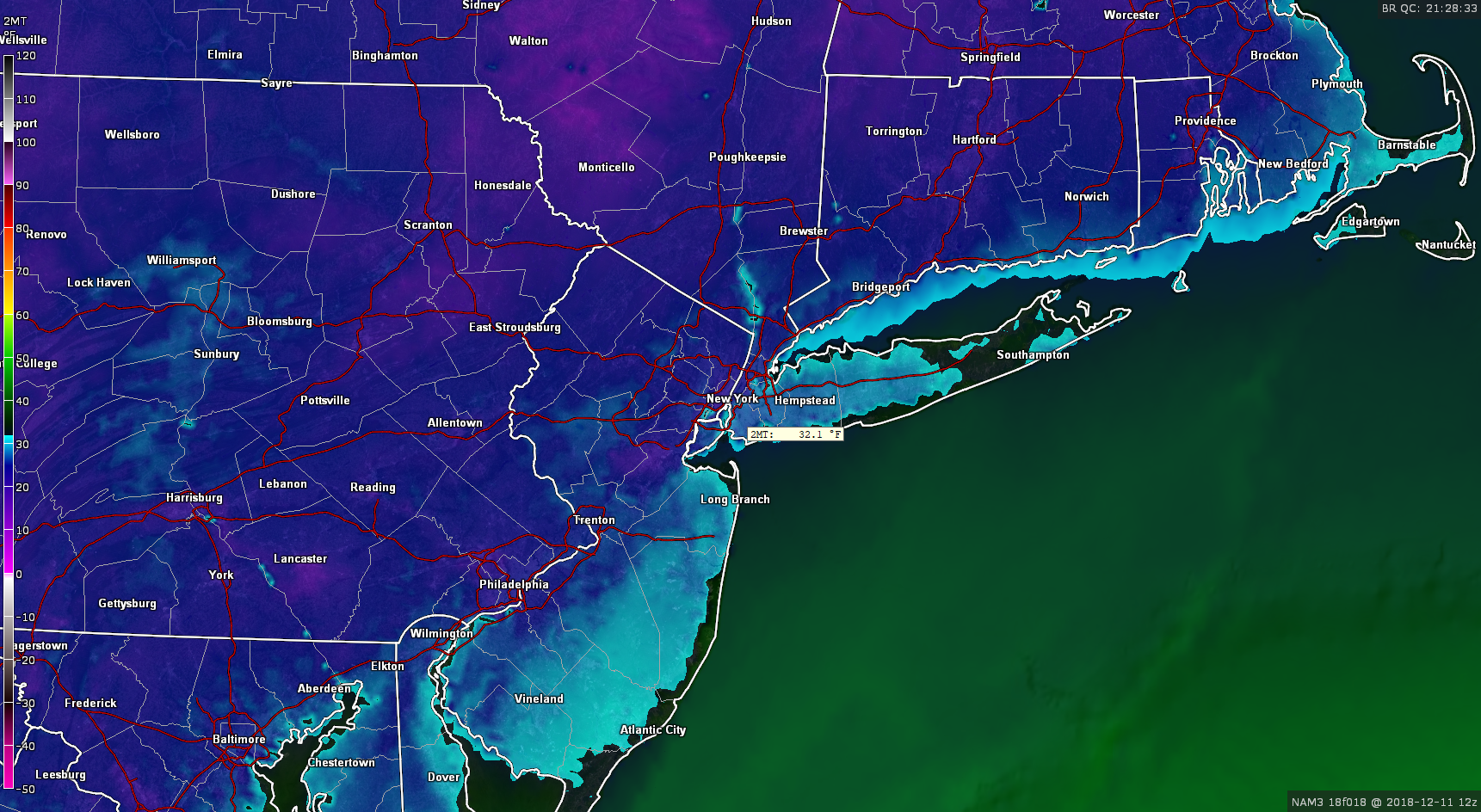
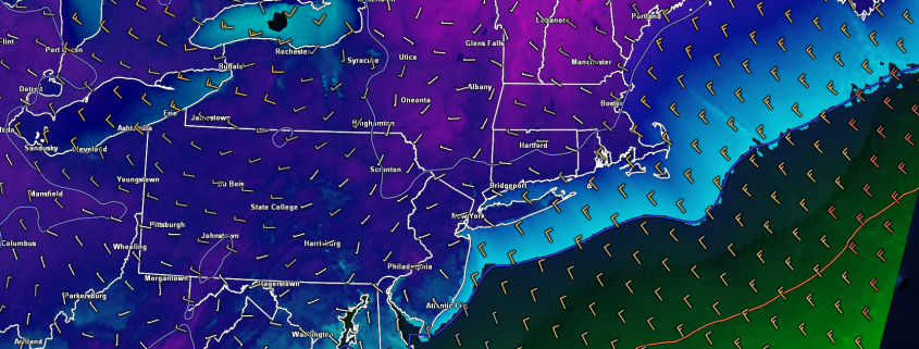
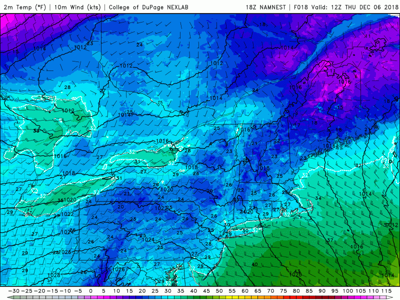
This evenings hi-res NAM model showing lows getting well-below freezing once again tonight for much of the area

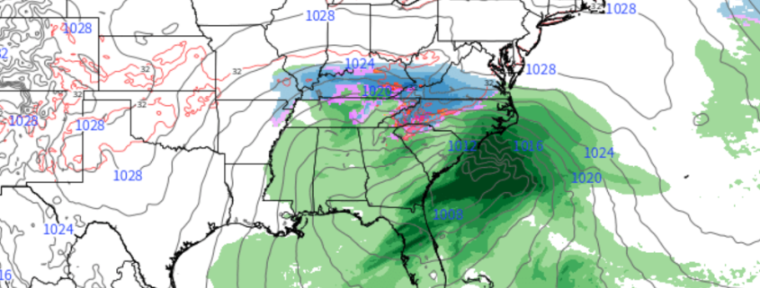
Cold and dry conditions once again dominate the Northeast

Those waking up for the AM commute Tuesday morning should expect more of the same, with very clear but also cold weather expected. Morning temperatures in and around the New York City area will likely be in the middle to upper 20’s-with lower 30’s likely in the city.

Yet another moisture-starved shortwave trough will be moving through portions of southeast Canada during the early afternoon hours, which should help to keep very dry/stable conditions over the Northeast. This dry air will allow for much of the region to stay mostly sunny, with the usual spotty clouds expected well off to the north and west over portions of New York state and Pennsylvania. Highs tomorrow afternoon will be quite similar to today, with temperatures staying in the middle 30’s for the majority of the region. Some readings closer to the coast may approach the lower 40’s, but it will still feel quite cool. As we head into the early evening and overnight hours, the weak shortwave trough that was previously located over portions of southern Canada will quickly move through the Great Lakes and into the Northeast. While this system is very dry and limited in its precipitation potential, there may be an outside chance at some flurries or light snow showers for locations to the north and west of the city. Lows tomorrow night will once again range from the middle to upper 20’s for the majority of the area, with the typical colder readings for locations to the north and west.

Wednesday should be another uneventful day across the Northeast as the area of high pressure that has been in control of our weather begins to gradually head to our east over eastern Canada. Stout northwesterly flow will be in place for the morning and afternoon hours which will allow for the same mostly sunny and cool conditions. Highs will likely be somewhat warmer during the day Wednesday when compared to Monday and Tuesday, but should still be slightly below-normal for this time of year with middle to upper 30’s likely for much of the area. The area of high pressure located over eastern Canada will begin to sink to the south and over New England on Wednesday night, which should provide another great chance at substantial radiational cooling. Expect lows dip down into the middle to upper 20’s for the area, which teens for inland locations.

As high pressure continues to sink to our east Thursday morning, another sneaky shortwave trough will be rapidly moving through the Great Lakes and into the Northeast. While this shortwave trough is relatively small and dry compared to its surrounding environment, the high pressure edging off the New England coast may be able to give this system a “boost” as the mid-level flow will be coming from the Southeast US instead of Canada. This could allow enough warm air advection to creep into the Northeast/Mid-Atlantic and interact with the dynamics of this shortwave to produce some light rain/snow showers (or even graupel) over the area on Thursday afternoon/evening.

Right now this solution isn’t set in stone and will have to be reviewed, but it’s something to keep an eye on in an otherwise boring pattern. With the aforementioned return flow coming from the south during the day on Thursday, we should see temps finally get into the upper 30’s and lower 40’s area-wide, though if the shortwave trough trends stronger/more moist, we could really put a cap on just how “warm” temperatures get Thursday afternoon.

NAM 500mb Vorticity

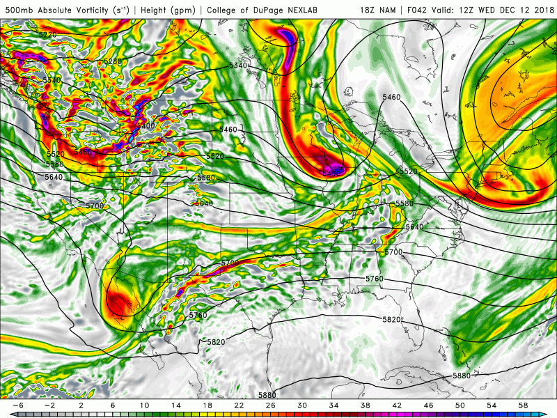
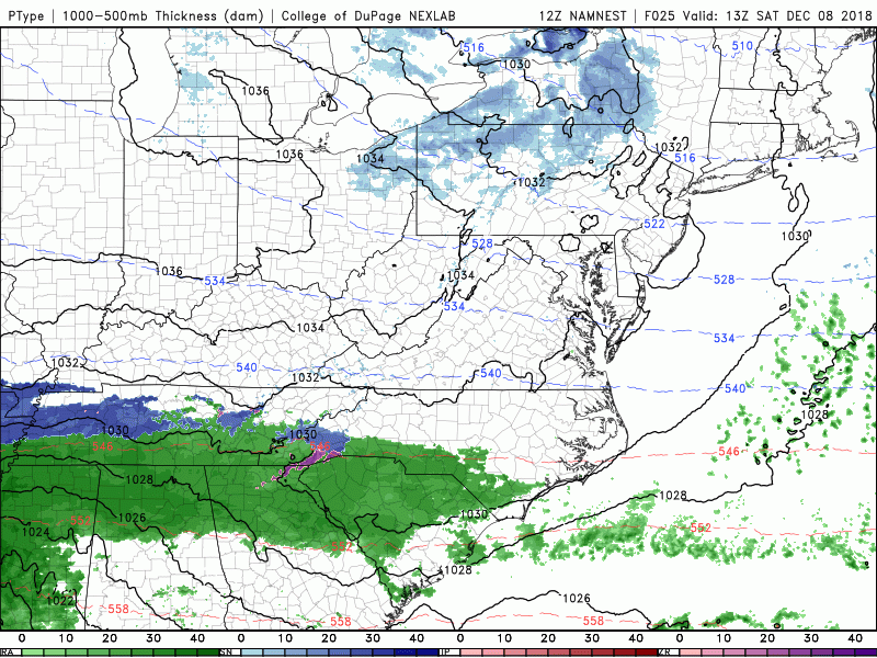
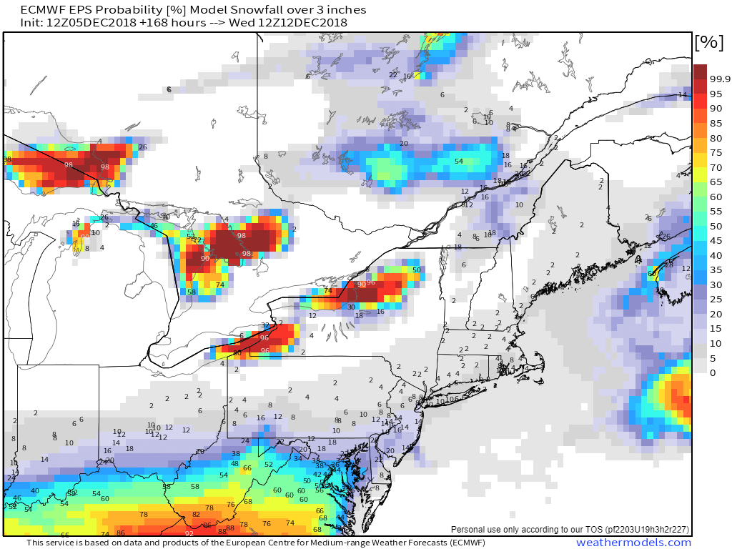
This evenings NAM model showing the small, but energetic “clipper” system approaching the Northeast on Thursday followed by a larger system taking shape in the South

Heavy rain threat growing for this weekend

As we head into late Thursday/Friday, a shortwave trough from the Pacific Northwest will drop into the Rocky Mountain region and begin to phase with another piece of energy over northern Mexico. The overwhelming majority of this afternoons model guidance indicates that the result of this interaction of these two systems will yield another large area of rain breaking out over the South just in time for this weekend. As this system continues to the east during the day on Friday, it will likely “cut off” from the main jet stream, which will allow it to slowly make progress over the Southeast US while dumping very heavy rainfall. Things get interesting on Saturday as we see a similar pattern to this past weekend, with confluence in southeast Canada, and a storm to the south.

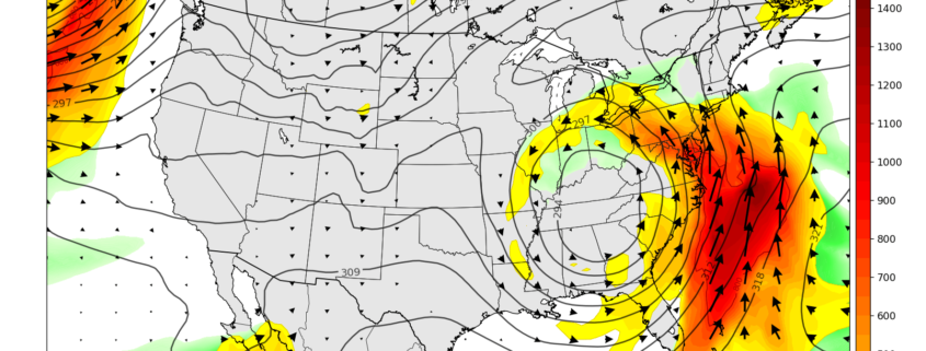
However, this time around there is no injection of cold air ahead of the storm and the confluence over Canada isn’t nearly as strong as it was this past weekend. This should allow for the upper-level low to very slowly move to the east and cause an impressive low-level jet streak to develop over the Southeast US and extend into the Northeast by Friday night. This low-level jet will be capable of transporting a very moist maritime tropical airmass from the Caribbean along the East Coast by Saturday morning, which will likely result in very heavy rainfall-and possibly even some flooding concerns. The evolution of the storm then becomes a bit more uncertain as we head into late Saturday and Sunday-with the potential for this upper-level low to linger in the East, which could prolong the rain/shower threat until Sunday.

ECMWF PWATS and 850mb Winds

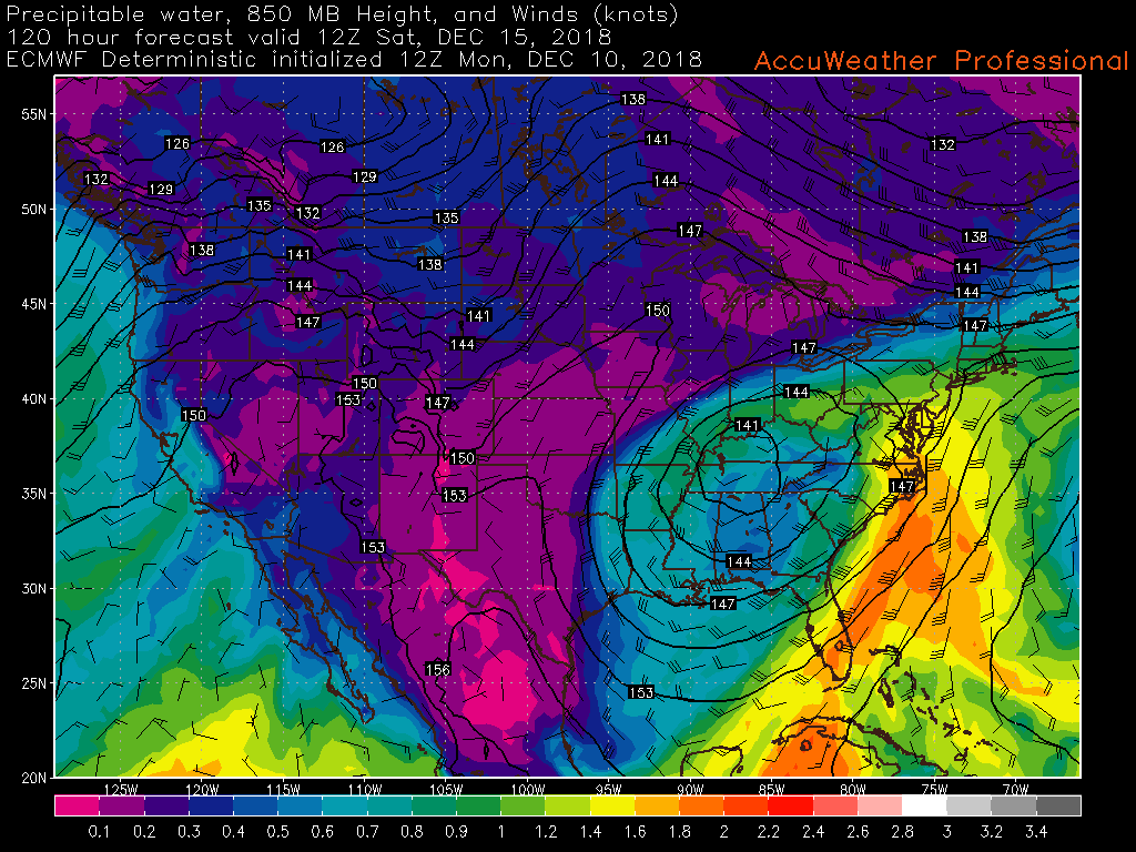
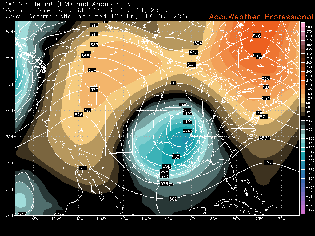
12z ECMWF model showing a very healthy and moist low level jet extending from the Southeast US and into portions of the Northeast (AccuWx Pro)

We’ll be keeping an eye on this potential system over the next few day’s to monitor any potential hazardous weather that may accompany it, so make sure to check back soon for further updates!

Have a great night! 

Steve Copertino


Snow passes to the south Sunday, cold and calm next week

Good afternoon! 

———————–

Things have once again turned quite calm over much of the Northeast today after a weak upper level disturbance moved through last night and produced some light snow well to the north and west of the New York City metro. Strong northwesterly flow behind this system has cleared out remaining moisture in the atmosphere and has replaced it with cold, dry Arctic air. Despite the cold mid level temperatures, clear skies have allowed for temperatures to rise into the middle to upper 30’s over much of the Northeast, with lower 40’s showing up in the city and portions of southern New Jersey.

The remainder of this afternoon will feature much of the same, with mostly sunny skies and light winds. There may be a chance at some more isolated snow showers if you’re traveling to eastern Pennsylvania and southern New York, but these should be quite tame. As we head into the evening hours and overnight, yet another Arctic shortwave will be passing to our north, which will provide a fresh injection of very dry and very cold air. Additionally, an area of high pressure will be edging it’s way into the Ohio Valley and Northeast. Given the dry air, fresh cold mid to upper level, and light winds, we fully expect radiational cooling conditions to be near-ideal tonight. This should allow overnight lows to drop well into the 20’s and teens over much of the Northeast, with even some single-digit readings possible. If you’re heading out tonight, definitely bring a heavy coast as it will feel more like January than December!

This afternoon's ECMWF model showing surface temperatures 12-20 degrees below normal Saturday morning (AccuWx Pro)

This afternoon’s ECMWF model showing surface temperatures 12-20 degrees below normal Saturday morning (AccuWx Pro)

Snowstorm passes well to the south later this weekend

Weekend Weather Rating | 8/10

As we talked about back on Wednesday and earlier this week, the storm we have been watching for the better part of the last ten days now appears to slide well to the south of the Northeast during the day on Sunday and into Monday. The models have trended even stronger with the confluence over eastern Canada over the past couple of cycles, which has caused an even greater shift to the south.

It now appears that places like Washington DC are unlikely to see any meaningful precipitation from this storm, while locations in southern Virginia and North Carolina may face a very impactful winter storm, with substantial snowfall and dangerous ice accretion. As of this update, the National Weather Service is forecasting snowfall totals of up to 12-18″, with locations in the mountains of NC likely to see over two feet of snow by Monday. Those who live in this region should be prepared to have normal operations and routines severely disrupted at least through Monday night-if not longer.

Back up north in our neck of the woods, Sunday should remain cold and clear, with a chance of increasing clouds towards sunset. Both Saturday and Sunday should feature highs in the middle to upper 30’s, with lows well into the 20’s. Locations well to the north and west should even be able to dip back down into the teens Saturday night.

Loop of this afternoons 3km NAM model showing the significant winter storm passing well to the south of the region this weekend.

Loop of this afternoons 3km NAM model showing the significant storm passing well to the south of the region this weekend. Heavy snow will be likely for portions of the Mid-Atlantic and Southeast

Quiet conditions and below normal temps persist into next weekend

After this weekend’s storm exits off the Southeast coast Monday night, we should see very quiet and cool conditions for the majority of the next week. Temperatures will likely remain 5-15 degrees below normal along the east through Wednesday, with lows sticking well-below freezing for the Northeast.

However, by the time we get to around Wednesday/Thursday, a large and energetic upper level disturbance will be moving into the Rocky Mountains. This upper level disturbance could be our next shot at some precipitation by the time we get to next weekend. At this time the models are showing an area of low pressure developing over the Midwest, which would bring a significant amount of moisture and warmer air up through the southern states and eventually into the Northeast. This would likely result in an increased chance for rain for the NYC area next weekend, but we’ll certainly be keeping an eye on this potential system during the course of next week.

500mb height anomalies from this afternoons ECMWF model showing an unusually deep closed upper level low over the south, with an area of ridging over the East.

500mb height anomalies from this afternoons ECMWF model showing an unusually deep closed upper level low over the south, with an area of ridging over the East.

Have a great weekend!

Steven Copertino


Unseasonably cold and dry conditions prevail, update on the snow threat this weekend

Good evening! 

Today was quite the interesting day across the tri-state area as the area of low pressure that we have been talking about for the past few days developed off of the New Jersey coast early this morning. This area of low pressure was spawned by a mid-level disturbance that was able to organize just at the last second as it approached the Mid-Atlantic coast. As both the surface low and the mid-level system both organized this morning, a narrow area of snow broke out over portions of southern New Jersey. This area of snow quickly grew from east to west during the early afternoon hours, extending back into eastern Pennsylvania at its peak. The small, but impressive band of snow virtually stalled over Atlantic county and produced snowfall rates of up to 1.5″ an hour. At the time of this article the highest snowfall totals from southern New Jersey are in the 4-6″ range, but it would not be surprising at all to see a few isolated reports come in higher. Elsewhere, there was a rather steep gradient with accumulations mainly in the 1-3″ range to the north and south of the main axis of heavy snow.

This area of low pressure and the associated surface trough are now beginning to pull to the east, causing any residual snow along the coast to wind down. We should see this low continue off the coast this evening, with calm and decreasingly cloudy conditions through the overnight hours for the vast majority of the Northeast. Usually a storm pulling away from the coast would produce near-ideal conditions for radionatal cooling all the way to the coast, but there appears to be a chance that stubborn mid/upper level clouds will hang on just enough, at least for the immediate New York City area. Accordingly, lows will likely stay in the middle to upper 20’s tonight, with middle to lower 20’s likely for locations to the north and west.

Latest high resolution water vapor imagery, surface temperatures, surface winds, and regional radar showing the area of low pressure responsible for the NJ snow beginning to head east

Latest high resolution water vapor imagery, surface temperatures, surface winds, and regional radar showing the area of low pressure responsible for the NJ snow beginning to head east

Unseasonably cold and dry conditions to continue through the weekend 

Thursday morning should start off like every other morning so far this week, with mostly sunny conditions and cold temperatures in the middle to upper 20’s for the AM commute. Clear and cold conditions should continue through the afternoon hours before a broad area of upper level energy approaches the region from the northwest. While this system should remain relatively dry given the fact the associated airmass is continental arctic, there may be just enough lift to spark the development of light to moderate snow showers towards the evening hours tomorrow night. While the bulk of this activity should stay over portions of New York state and Pennsylvania, it would not be all that surprising to see some narrow bands extend all the way back into portions of New Jersey and possibly even NYC. Otherwise, increasing cloudiness will put a lid on low temperatures tomorrow night, with temperatures likely staying in the middle to upper 20’s for the majority of the tri-state area.

By the time we get to Friday morning, yet another shot of cold/dry air will quickly move through the Northeast, likely clearing out any residual clouds from the previous night. Temperatures should stay in the upper 20’s to lower 30’s during the day on Friday, but occasionally gusty winds may make conditions feel a good 10-15 degrees cooler. Winds will likely calm down during the afternoon hours on Friday as an area of high pressure begins to edge into the East. With high pressure in control and all levels of the atmosphere very dry, we should see excellent conditions for radiational cooling to occur. Lows on Friday night will be quite cold, with readings dropping well into the 20’s, with teens likely for portions of NW New Jersey and southern New York. All in all, temperatures over the next few days will  range anywhere from 5-15 degrees below normal across the entire Northeast, which is much more like January as opposed to early December.

Loop of the 18z 3km NAM showing unseasonably cold conditions persisting throughout the next few days.

Loop of the 18z 3km NAM showing unseasonably cold conditions persisting throughout the next few days.

Late weekend storm likely to stay south of the NYC area

Over the past five days or so we have been watching numerous pieces of energy in the atmosphere located over the Arctic, the Pacific, and Alaska which will likely interact with one another by the time we get to Saturday afternoon over the Southern Plains. As these pieces interact, a large area of heavy rain and snow will gradually develop and begin to produce a swath of significant snow that could extend from Oklahoma to the Mid-Atlantic coast when all is said and done. While we do know that these various pieces for the storm will likely come together, what we don’t have nailed down yet is exactly how and when they will do so.

As of right now, the most likely scenario is that the main upper level system over Texas will begin to strengthen during the day on Saturday, while another piece of energy from the Arctic dives into the Northern Plains, causing the main storm to speed up. Additionally, another area of energy will likely be located over Southeastern Canada, which will be injecting very dry air over portions of the Mid-Atlantic and Northeast. This dry air will essentially act as a wall during the day on Sunday as the main surface low moves through the Southeastern US and tries to make some northward progress. At this point, the forecast will be dependent on just how strong the disturbance over Southeast Canada is at the time. If the system is weaker, there is a chance that meaningful precipitation is able to make its way north and impact DC to Philadelphia. However, the model runs from this afternoon showed increased dry air and “confluence”, forcing the main impacts down into portions of KY, WV, VA, and NC.

While there is still time left before Saturday, we feel that there will likely not be significant enough changes with the predicted upper air pattern to cause any major changes with this forecast for the NYC area.

In summary, it appears increasingly likely that the immediate NYC area will remain well to the north of any potential impacts, with only increasing clouds and cold temperatures during the day on Sunday.

Current states at highest risk for significant winter weather impacts: KY, NC, SC, VA, WV

Current states at risk for some impactful winter weather, with high uncertainty: MD, DE, PA, NJ

Current states with lowest risk for impactful winter weather: NH, VT, ME, MA, CT, NY, RI

51-member ensemble from the European model showing the probability of 3" or greater of snow. At this time significant impacts from this system are quite low.

51-member ensemble from the European model showing the probability of 3″ or greater of snow. At this time significant impacts from this system are quite low.


Make sure to check back in during the day tomorrow for more updates on this system!


Steve Copertino

NYC Area Forecast: Updates on snow threats

Briefing: Bands of snow may impact isolated parts of Eastern NJ on Wednesday, and a larger coastal storm passes to our south later this weekend. Impacts are currently expected to be negligible in NYC for both – but uncertainty on the weekend storm system remains high.

Dry, calm and cold weather has settled in to the Northeast states today, and is expected to generally remain in place through the middle of the week. The forecast remains extremely interesting and highly convoluted, however, as multiple disturbances will pass by the Northeast states.

The larger focus will be on the system this weekend, and rightfully so, but a prior system – which passes off the NJ Coast on Wednesday – may have some tricks up its sleeve.

Read more